Fig. 1
Macroseismic effects of the "Athens99" earthquake: a preliminary report
1.Working team:
Dr. Vassiliki Kouskouna-Tsimbidaros, Laboratory of Seismology, Department
of Geophysics & Geothermy, University of Athens
Dr. Paola Albini, Istituto
di Ricerca sul Rischio Sismico, CNR, Milano
2.Introduction
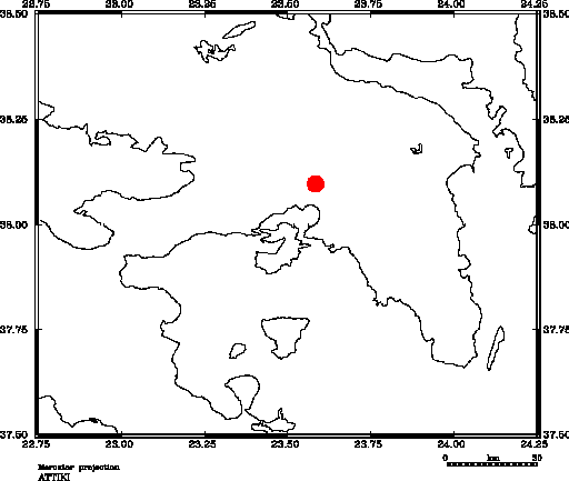
On September 7, 1999 at 11.56 GMT (14.56 local time) a damaging earthquake
hit the central part of the region of Attica, where the city of Athens is
located (Fig. 1). Its magnitude was estimated as
MW=5.9 on the Richter
scale and its instrumental epicentre was located by CORNET network of the
Laboratory of Seismology, Department of Geophysics & Geothermy of the
University of Athens at
3805.81'N,
23035.03'E, with
a depth of 17 km. The aim of this survey, performed between 8 and
12 September and carried out by the common efforts of the Laboratory of
Seismology, Department of Geology, University of Athens and the Istituto
di Ricerca sul Rischio Sismico, CNR, Milano, is to gather data on the
macroseismic effects due to this earthquake and to produce a map of damage
distribution according to the European Macroseismic Scale 1998. What follows
is a short report, supplying information on the visited area and some preliminary
assessment of damage.
3.The affected area and its seismic history
The central part of Attica is densely inhabited, and it includes the city of Athens, capital of Greece and its surrounding suburbs, as well as the port of Piraeus in the south. The seismic history of this part of Attica is recorded mainly through the effects in the city of Athens (Ambraseys, 1993). Few earthquakes of low magnitude have been recorded in the 20th century. The activated fault is not known to have produced significant earthquakes in the past, although some historical earthquakes are so poorly known that they could be attributed to this same fault. According to preliminary interpretation of the CORNET instrumental data, the direction of the fault is believed to be WNW-ESE.
4.Macroseismic survey
Data on macroseismic effects have been collected in the form of photographic
records, by means of reflex cameras, a digital as well as a video camera.
Individual observations and personal communications are also included. Assessment
of grade of damage according to EM98 scale is in progress. In four different
field trips between 8 and 12 September, the damaged area, located mainly
north and northwest from the centre of Athens, was approached from different
routes. This enabled us to survey a certain number of the main damaged suburbs
(according to a note from the Greek government the most damaged number around
20) which are shown in Fig. 2.
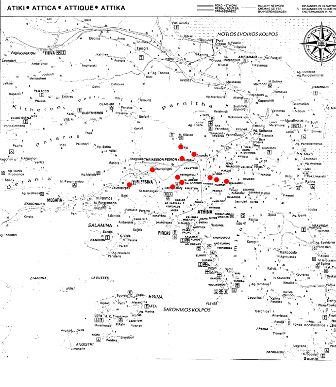
Elefsina: Structural damage to a few one-storey buildings was observed in the part of the town near the archaeological site (grade of damage 3 and 4). Slight to negligible damage was also observed (photograph 1).
Photograph 1, 8 Sept. 1999: Elefsina (84 Kbyte)
Photograph 2, 8 Sept. 1999: Ano Liossia (100 Kbyte)
Photograph 3, 8 Sept. 1999: Ano Liossia (89 Kbyte)
Photograph 4, 8 Sept. 1999: Cemetery of Ano Liossia (114 Kbyte)
Nea Liossia
Photograph 6, 12 Sept. 1999: Nea Liossia (291 Kbyte)
Aspropyrgos
Chaidari
Petroupoli
Nea Philadephia
Nea Ionia
Kamatero
Acharnes (Menidi)
Fili
Chalandri
Filothei
Pangrati
A summary of observations similar to the one supplied for Elefsina will be made available for the remaining suburbs.
5.Comments
Rock falls were observed at the foothills of mount Parnis, on the road from Aspropyrgos to Fili. This earthquake also caused damage to some monumental buildings in the centre of Athens and surrounding areas. Damage in various parts of Piraeus (south to the centre of Athens) was also reported, but not yet verified. The earthquake was strongly felt in Pachi to the west and Nea Makri to the east (Fig. 2). The investigation on the extension of the far field area is still in progress.