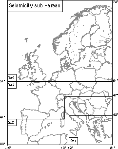
Preliminary seismicity sub-areas and size classes.
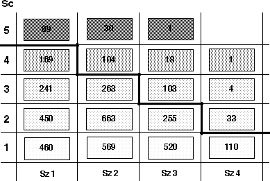
Distribution of the damaging earthquakes in 4 sub-areas and 5 size classes. The "strong" earthquakes are above the bold line.
Task 4 - The European Earthquake Roots Archive
Goals
After the investigation performed at Task 3, the situation of roots has
considerably improved. The goal of Task 4 is to compare the old roots
(Task 2) with the new ones (Task 3), to select the best ones to form the
most updated European comprehensive roots archive.
They will serve as an input for re-parameterisation and as a reference for
future upgrading.
These goals will be undertaken with special reference to damaging
earthquakes; they will be completely achieved for a set of
strong earthquakes.
A special sub-goal of Task 4 is the creation of the European Intensity
Database, putting together and homogenising the available intensity data.
The inventory of damaging earthquakes
Input PEC are inhomogeneous with respect to the lower size threshold, as
shown by the table:
|
PEC code |
Io or Ix |
|||||||||||||||||||||||
|
|
|
No value |
>= 4/5 |
5 |
5/6 |
6 |
6/7 |
7 |
7/8 |
8 |
8/9 |
9 |
>9 |
|||||||||||
|
MUS94 |
13 |
24 |
62 |
21 |
23 |
6 |
12 |
1 |
5 |
|||||||||||||||
|
HOU92 |
18 |
1 |
1 |
1 |
5 |
2 |
12 |
2 |
4 |
1 |
(1) |
|||||||||||||
|
VGL91 A |
32 |
12 |
12 |
2 |
6 |
2 |
||||||||||||||||||
|
B |
2 |
1 |
1 |
1 |
4 |
|||||||||||||||||||
|
C |
374 |
- |
138 |
- |
50 |
- |
9 |
- |
3 |
|||||||||||||||
|
LEY86 |
58 |
92 |
26 |
74 |
25 |
52 |
7 |
11 |
1 |
|||||||||||||||
|
GRU88 |
63 |
39 |
19 |
8 |
7 |
2 |
1 |
|||||||||||||||||
|
POS85 |
2356 |
311 |
1884 |
220 |
738 |
140 |
635 |
58 |
223 |
18 |
79 |
38 |
||||||||||||
|
RIB82 |
3 |
43 |
49 |
19 |
35 |
15 |
18 |
6 |
5 |
1 |
2 |
1 |
||||||||||||
|
HER95 |
5 |
57 |
24 |
38 |
28 |
220 |
35 |
75 |
13 |
51 |
9 |
|||||||||||||
|
ZSA88 |
5 |
40 |
190 |
14 |
62 |
12 |
51 |
6 |
22 |
1 |
10 |
1 |
||||||||||||
|
COM82 |
23 |
9 |
11 |
4 |
14 |
6 |
50 |
7 |
20 |
5 |
6 |
2 |
||||||||||||
|
SUK75 |
3 |
27 |
5 |
30 |
7 |
14 |
1 |
|||||||||||||||||
|
PAP89 |
3 |
11 |
- |
37 |
- |
85 |
- |
87 |
39 |
|||||||||||||||
|
SHA74 |
50 |
7 |
19 |
202 |
35 |
151 |
32 |
120 |
61 |
|||||||||||||||
|
AHU92 |
2 |
38 |
223 |
5 |
27 |
7 |
||||||||||||||||||
|
LAA96 |
88 |
114 |
49 |
68 |
24 |
41 |
17 |
13 |
1 |
2 |
||||||||||||||
|
MEM83 |
816 |
- |
92 |
- |
80 |
- |
87 |
- |
44 |
- |
22 |
8 |
||||||||||||
|
KSH82 |
9 |
16 |
12 |
16 |
13 |
8 |
3 |
12 |
3 |
1 |
||||||||||||||
|
LAB95 |
3 |
2 |
38 |
2 |
23 |
3 |
12 |
3 |
5 |
1 |
||||||||||||||
|
GRA78 |
1 |
1 |
6 |
3 |
10 |
6 |
7 |
4 |
4 |
3 |
1 |
3 |
||||||||||||
|
PAJ72 |
30 |
2 |
1 |
2 |
1 |
|||||||||||||||||||
Therefore, the analysis from this stage on was devoted with priority to
"damaging earthquakes", adopting a conventional, preliminary size
threshold (Ix/Io >= 5/6 or M >= 4.0).
The initial file of damaging earthquakes (IfDE)
was obtained selecting the roots corresponding to the F entries in
the BEECD WF with size above the adopted threshold. This set contains
4083 roots; the contribution of each input PEC is given in
Tab. 4.1, while the
distribution of the root class is given in
Tab. 4.2.
This file was merged with the new roots file (NRf, App.
F2); each new root was associated to the corresponding "families" assessed
in the compilation of the BEECD WF, that is, it was given the corresponding
value of Fn. The families were then sorted out by means of the root
class Rc: the best root was adopted and given the code R =
ruling, red to the P (preference) parameter; additional
new roots of lower Rc corresponding to the same earthquake were given
the code S = secondary, magenta. When no new roots were available
or when a new root had Rc lower than the initial one, the
initial root was adopted and given the code I =
initial, green.
The making of the final, upgraded roots file of damaging
earthquakes (URfDE) is partially given in App. G1.
The R (red) and I (green) roots form the
data set from which the new parameters are to be determined.
The earthquake root archive
The root archive is composed by roots of varied type and quality. For the
next steps, and for allowing a uniform, transparent procedure to be followed
in the future, it is important that they are compiled according to standard
format; it is not strictly necessary that they are all resident in the same
place. Here follow some ideas.
Roots of type 1: the intensity database
As discussed in Task 2, the most suitable roots for earthquake parameters
determination are those of type 1, that are, roots supplying intensity data.
Roots of type 1 exist for about 950 earthquakes, which represent about the
23% of the total number of damaging earthquakes in the time-window
1400-1899; in all, a number of about 20.000 intensity datapoints exist
in this time-window. According to the results of a preliminary survey performed
in the frame of the ESC WG "Macroseismology", the situation improves in the
XX century, when macroseismic surveys, performed by means of questionnaires,
were organised in many countries, though with no constant effort throughout Europe and the whole century. However, only a few country (France,
Italy) have a consistent, accessible intensity database as yet (Monachesi
et al., 1995; Levret et al., 1996; Monachesi and Stucchi, 1997; etc.).
In general, intensity data are compiled according to varied formats (see
Task 2, roots of type 1). As recent experiences have shown the management
of an intensity data set is made simple by the use of a relational database.
Wishing that the database is homogeneous requires that parameters are homegenous
on their turn. For instance, it is necessary that intensity data are always
given in the same macroseismic scale, which is not the case of European
countries, yet.
Furthermore, it is necessary that the same place is always called with the
same name and given the same co-ordinates, referred to the same co-ordinate
system; it is therefore necessary to adopt a geographical authority (gazetteer)
to which all datapoints are to be referred; in some cases such authority
needs ad hoc implementation. Europe has no unified, available gazetteer so
far; rather, each country, or at least most of them, have one, or even more
than one. An attempt to build up a uniform gazetteer for BEECD was initiated
by exploring the GEOnet Names Server (GNS) (next page, from
Martello and Camassi, 1996). To complete it was not a task for BEECD, although
a future European Intensity Database strongly needs it.
Ad hoc solutions for dealing with special cases, such as change of locality
name with time, displacement of localities with the same name, incorporation
of a locality into another one, etc. can be dealt with by means of a dedicated
parameter Sl (see for instance, bottom, from Monachesi and Stucchi, 1997, A European place-names and co-ordinates database for BEECD).
See
The intensity datapoint is the minimum informative unit which carries at least the following information: time, location and intensity. To be handled by databases, intensity datapoints need to be compiled in a uniform way; moreover, it might be useful that they carry some additional information, such as root to which they belong, source of the information, locality denomination (in the source), code(s) of the gazetteer, country of the locality, quality code of the datapoint and some parameters of the earthquake to which they belong, when determined. Tab. 4.3 presents an example of format according to which intensity data can be compiled.
As for data quality, the coding system proposed by Musson (1998) is recommended:
Binary quality code table (Q)
|
Integer |
Bits |
Problems |
|
0 |
000 |
None |
|
1 |
001 |
Reliability |
|
2 |
010 |
Locational |
|
3 |
011 |
Reliability + locational |
|
4 |
100 |
Veracity |
|
5 |
101 |
Reliability + veracity |
|
6 |
110 |
Locational + veracity |
|
7 |
111 |
All three |
Roots of type 2 and 3
These roots represent respectively the 36% and 19% of the total
number of damaging earthquakes: altogether, the 55%.
They were produced by a number of authors or agencies and reported according
to varied format. To make them comparable one to another, a short report
was designed containing:
As already described, the roots produced in the frame of BEECD are reported according to the agreed format (App. E1.1 to E1.3), adopted as a minimum. For the studies not produced in the frame of BEECD a standard comment (App. E2.1 to E2.11) was designed.
Fake quakes
As mentioned above, it is opportune that investigations which prove earthquakes
to be fake are reported in a similar way as for the "true" ones, explaining
the causes of the distortion (App. E3.1 to E3.5). Obviously, no parameters
will be determined in this case.
A catalogue of "fake quakes" will represent one of the output of the project.
This catalogue might be expanded to the time-window before 1400, where fake
quakes are more frequent.
Roots of type 4 and 5
Obviously, and unfortunately, SRfDE contains also about 900 roots
of type 4 and 5, which represent the 22% of the total number
of entries.
For these roots little can be done, except that retrieving the original
parametric entry from which they derive and to check whether the parameters
have been correctly adopted.
The situation of the Strong Earthquakes
For many issues, like seismotectonic analysis and seismic hazard assessment,
the largest earthquakes play a major role. To have a close up of the situation
of the damaging earthquakes (how much did they improve from the stage of the
WF? how much has it to be done in the future? according to which priority?),
the strong earthquakes were taken as a test.
As seismicity is very uneven in Europe with respect to maximum size and frequency
of occurrence, the damaging earthquakes (IfDE ) were first divided
- in a very preliminary way - in four zones and five size classes
(see the figures).
The seismicity zones were defined with the only reference to this goal and
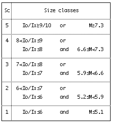
do not represent any seismicity interpretation. The size classes were defined
adopting Ix and Io as ruling parameters and "fishing out" some events with
M larger than the most frequent values for the corresponding class of Ix/Io.
The "strong earthquakes" were then selected adopting decreasing size
thresholds for the 4 zones.
The output is a set of 383 earthquakes, thereafter named as initial
file of strong earthquakes (IfSE). It has
to be understood that in many cases these earthquakes represents the main
event of a sequence which has to be investigated and reported as a whole.
The distribution of the 383 entries with respect to the input PEC
is given in Tab. 4.4; their
plot is given in Fig.4.1,
4.2 and
4.3. The root class
and level distribution of the 383 entries is given in
Tab. 4.4,
Fig. 4.4 and Fig.
4.5; the plot of the root level distribution is given in Fig. 4.6.
Extracting from the SRfDE the roots corresponding to the 383 strong earthquakes and combining them with IfSE one gets the "combined file of strong earthquakes" (CfSE, App. G2), which shows the present situation. It contains:
|
|
TOT |
|
level I |
level II |
level III |
||||||||||||
|
|
1A |
2A |
1B |
3A |
2B |
1C |
3B |
2C |
4B |
3C |
4C |
5 |
|||||
|
|
|||||||||||||||||
|
initial file |
383 |
|
17 |
10 |
31 |
20 |
55 |
17 |
35 |
72 |
- |
61 |
64 |
1 |
|||
|
upgraded file |
383 |
|
71 |
51 |
94 |
16 |
47 |
7 |
18 |
26 |
- |
37 |
16 |
- |
|||
A European place-names and co-ordinates database for BEECD
With the aim of providing a source of data that could be used for a uniform
geo-referentiation of the intensity datapoints, the GEOnet Names Server
(GNS), which provides Internet access to the database of foreign
geographic feature names, was explored. This site allows accessing to the
database geographic names (Geographic Names Database - GNDB) of the
National Imagery Mapping Agency (NIMA), an agency of the Defence
Department of the USA that supplies geospatial information to national political
and military organisations. The database actually consists of 35 regional
data sets. The original data were derived by querying the Geonet Names Server;
the data have been modified and applied a new format, namely a dbf format.
The table below gives a list of all the data sets
created so far.
| country |
code |
entries |
country |
code |
entries |
| Albania | AL | 14.027 | Luxembourg | LU | 1.115 |
| Armenia | AM | 2.376 | Macedonia | MK | 2.761 |
| Austria | AU | 19.586 | Malta | MT | 604 |
| Azerbaijan | AJ | 7.808 | Moldova | MD | 5.301 |
| Belarus | BO | 17.041 | Montenegro | MW | 2.158 |
| Bosnia & Herzegovina | BK | 7.327 | Netherland | NL | 9.375 |
| Bulgaria | BU | 20.688 | Romania | RO | 9.100 |
| Croatia | HR | 7.992 | San Marino | SM | 5 |
| Cyprus | CY | 2.155 | Serbia | SR | 7.361 |
| Czech Republic | EZ | 23.734 | Slovakia | LO | 6.960 |
| Estonia | EN | 8.863 | Slovenia | SI | 5.133 |
| France | FR | 75.102 | Spain | SP | 36.663 |
| Georgia | GG | 7.044 | Switzerland | SZ | 3.648 |
| Germany | GM | 79.983 | Turkey | TU | 59.679 |
| Greece | GR | 21.205 | Ukraine | UP | 42.684 |
| Hungary | HU | 19.608 | United Kingdom | HU | 16.801 |
| Italy | IT | 21.305 | |||
| Latvia | LG | 9.427 | |||
| Liechtenstein | LS | 22 |
Total |
|
594.641 |
All the original data have been collected and formatted by the American Governmental Institute in different times, starting from the '60 up to now. The last column shows the amount of records got from the queries. The American database allows to specify the requested kind of records; so far only populated places were considered. A few tests, mostly concerning Italy and Albania, have been carried out (Siro and Camassi, 1996) in order to check the reliability of the data against other reference systems. It has been possible to note that data are pretty reliable, although it must be pointed out that the level of accuracy varies depending on the European country.
Special locality cases (SL)
| DL |
deserted locality. Locality no longer inhabited, which can be now a "ruin" or just a toponyim. In some cases it can have been rebuilt in another place with the same name or a different one. |
|
AL |
absorbed locality. Locality once independent which was absorbed by a contiguous one. |
|
MS |
multiple settlement. In some cases the information associated to the given name corresponds to a set of small localities (e.g. a small administrative unit, a small island, etc.) and cannot be referred to a single one of them. |
|
TE |
territory. The information refers to an area (e.g. Lombardia, Provence, Peloponnesus). In such cases it is suggested not to assess intensity but to give a code for classifying the effects (e.g.: DE = destruction; D = damage; F = felt; NF = not felt) and to supply no co-ordinates. |
|
SS |
small settlement. These are the cases of a country church surrounded by a few buildings, a large farmhouse, a castle, etc. and of all the situations where the size of the settlement is below the threshold suggested by Gruenthal (1998). It is suggested not to assess intensity but to give a code for classifying the effects (e.g.: DE = destruction; D = damage; F = felt; NF = not felt). |
|
SB |
solitary building. Case similar to the previous one (church, tower, lighthouse, etc.). To be dealt with in the same way. |
|
NL |
not located. Locality the location of which was impossible so far. |