| |
European-Mediterranean
| 
|
|
| ||
| |
European-Mediterranean
|
|
|
| ||
European-Mediterranean Intensity Database (EMID)
1. Scope
The scope of EMID is to inventory, put together, compile according to uniform standard and format, make available to public and keep updated the intensity data concerning earthquakes located in the Euro-Mediterranean region.
This task is performed in the frame of the initiatives of the EMSC/CSEM Key Nodal Member for the dissemination of long-term seismicity data (Istituto Nazionale di Geofisica e Vulcanologia, Dept. of Milano, former Istituto di Ricerca sul Rischio Sismico, CNR, Milano), with the contribution of all investigators who supply intensity data.
EMID will host intensity datasets which are public or made available on the purpose. Authors of the datasets are acknowledged and are responsible of the data released. In case of multiple studies of the same earthquake, all available datasets will be released.
All investigators from the European-Mediterranean region who are authors of earthquake studies providing intensity data are encouraged to share the data with the scientific community through this initiative.
2. Disclaimer
EMID is not responsible for improper use of the data. The database is upgraded constantly; the absence of data concerning some earthquakes does not strictly mean that they do no exist, but rather that they could not be made available, yet.
3. State-of-the-art (August, 2002)
Fig.1 shows the distribution of the intensity datapoints as today available in digital form. They are currently being qualified, geo-referenced and checked with respect to their status (public/versus restricted). Fig.2 shows the distribution of the data which are available through this web site, as a demo.
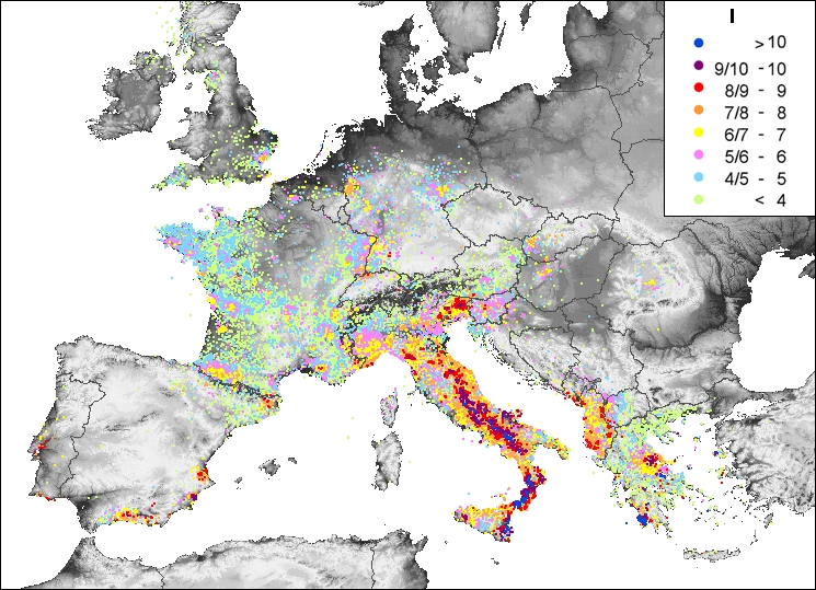
Fig.1 - Distribution of the intensity datapoints available in digital format (Aug. 2002)
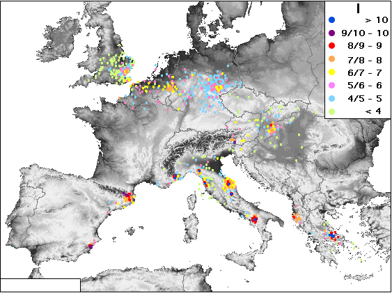
Fig. 2 - Distribution of the intensity datapoints available through this web site (Aug. 2002)
4.a - Background
One of the goals of the former EC BEECD project (A Basic European
Earthquake Catalogue and a Database for the Evaluation of Long-term Seismicity
and Seismic Hazard, 1995-1998) was the start of the compilation of
a comprehensive European Earthquake Root Archive, to serve
as an input for earthquake re-parameterisation and as a reference for future
upgrading.
In the current parametric catalogues the earthquake roots, that are
the datasets form which the earthquake parameters are determined,
range from:
- no information at all (type 5)
- a set of parameters taken from another parameter catalogue (type 4)
- a few lines, compiled for summarising the earthquake knowledge (type 3)
- papers or monographs reporting comprehensive investigation on specific
earthquakes (type 2)
- papers or monographs on specific earthquakes, with macroseismic intensities
assessed for each locality (type 1).
With respect to damaging earthquakes with (Ix/Io >= 5/6 or M >= 4.0), the share of the root type in the time-window 1400-1899 (4083 earthquakes) is the following:
| type 4 & 5 | 22% |
| type 2 & 3 | 59% |
| type 1 | 19% |
4.b - The roots with intensity datapoints (IDP)
The most suitable roots for earthquake parameters determination are those
supplying intensity data (type 1); as shown above, they are only a minority
so far.
Only a few country (Italy, France) have a consistent, accessible set of intensity
datapoints (IDP) as yet, offered on magnetic (Boschi et al., 1997; Monachesi and Stucchi, 1997) or on paper (Levret et al., 1996)
support.
In other areas, some data are presented in terms of isoseismal maps, either
without IDP (es.: Mezcua, 1982, etc.) or with IDP (es.: Shebalin,
1964; Papazachos et al., 1997, etc.), though the coordinates of the datapoints
are not easily obtainable and the place-names are missing.
Further intensity data concerning some earthquakes exist; however, some of
them may be not public, and even to inventory them is often a difficult task.
The BEECD project performed an inventory of the existing intensity data and
the format in which they come; moreover, it promoted the creation of about
90 roots of type 1 referring earthquakes for which no IDP were
available.
The result is that, in the the time-window 1400-1899 and with respect
to damaging earthquakes, IDP exist - in principle -
for about 800 earthquakes, which represents about the 19% of
the total number earthquakes; in all, a number of about 27.000 IDP
is reported as existing in this time-window (an estimated number of about
2000 IDP, concerning some tens of earthquakes for which the number
of available IDP was not made available, could be added). Of course, these
figures can be updated.
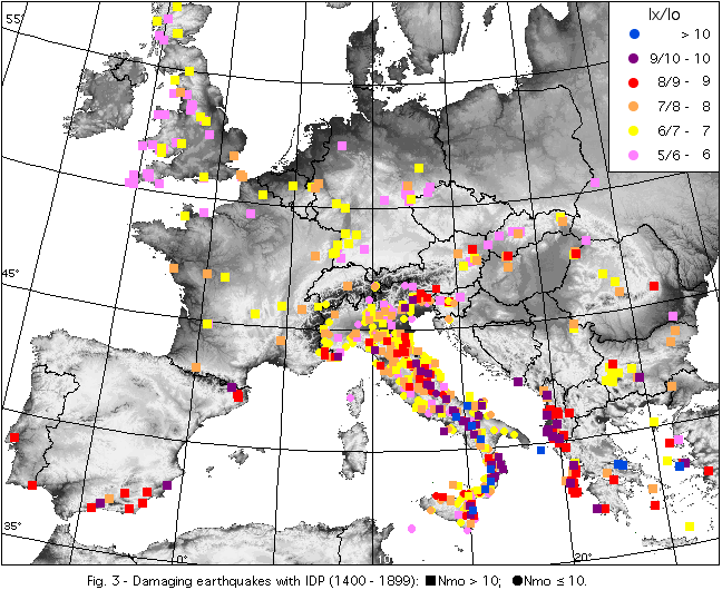
The distribution of these figures is far from being even throughout
Europe, as it reflects efforts of varied purpose and size. Out of the 800
earthquakes with IDP, about 540, carrying about 16.500
IDP, are from the Italian area (by the way, they represents the 56% of
the total number of damaging earthquakes in Italy; the remaining 44 % contains
earthquakes with Io =< 7 only). The other regions contributes with 260
earthquake studies carrying a limited number of IDP each or, in the case
of a few, strong, XIX century earthquakes, carrying up to hundreds of IDP
(Fig. 3).
Obviously, the number of IDP varies according to: size of the earthquake,
investigation accuracy, sources survival and time from present. As an example,
IDP concerning XIX century earthquakes are about 20.000;
the remaining 7.000 concern the previous
centuries.
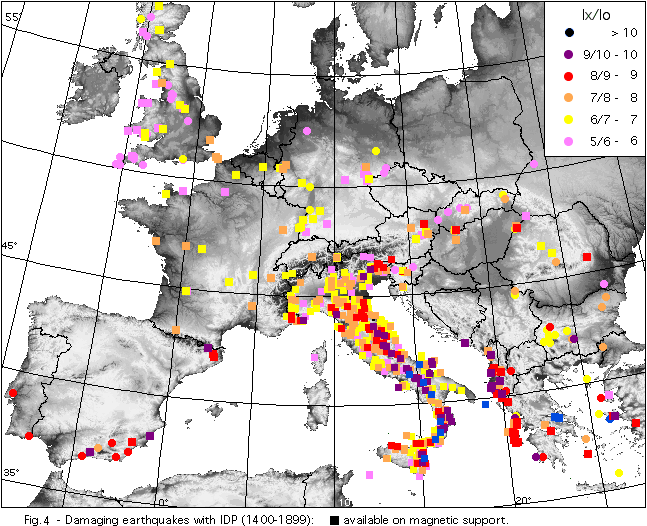
IDP are not always public: as an example, out of the about 260
earthquakes outside the Italian area, 158 are public while 102
are under negotiation.
A limited number of earthquakes with IDP (the survey is in progress) is also found in the time-window 1000-1399, the largest contribute coming once again from the Italian area. On the other hand, according to the results of a preliminary survey performed in the frame of the ESC WG "Macroseismology" (1996), and to some tests performed in the frame of the BEECD project, the situation improves in the XX century, when macroseismic surveys, performed by means of questionnaires, were organised in many countries, although with no constant effort throughout the whole Europe and the whole century.
Once the IDP tables are compiled, it is necessary that the same place is
always called with the same place-name and given the same co-ordinates, referred
to the same co-ordinate system; it is therefore necessary to adopt a common
geographical authority (gazetteer) to which all datapoints are to be referred
(by the way, only 92 earthquakes out of the 260 have coordinates).
Europe has no unified, available gazetteer so far; rather, each country,
or at least most of them, have one, or even more then one; in some cases
such authority/ies needs ad-hoc implementation. An attempt to build up a
uniform gazetteer was initiated by exploring the GEOnet Names Server
(GNS) (see the BEECD Final Report); the Euro-Mediterranean
Intensity Database strongly needs a uniform gazetteer.
Ad-hoc solutions for dealing with special cases, such as change of place-name
in time, displacement of localities with the same name, incorporation of
a locality into another one, etc. can be dealt with by means of a dedicated
parameter SL (see below,
from Monachesi and Stucchi, 1997).
|
Special locality cases (SL) |
|
| DL |
deserted locality. Locality no longer inhabited, which can be now
a "ruin" or just a toponyim. In some cases it can have been rebuilt in another place with the same name or a different one. |
| AL | absorbed locality. Locality once independent which was absorbed by a contiguous one. |
| MS | multiple settlement. In some cases the information associated to the given name corresponds to a set of small localities (e.g. a small administrative unit, a small island, etc.) and cannot be referred to a single one of them. |
| TE |
territory. The information refers to an area (e.g. Lombardia, Provence,
Peloponnesus). In such cases it is suggested not to assess intensity but to give a code for classifying the effects (e.g.: DE = destruction; D = damage; F = felt; NF = not felt) and to supply no co-ordinates. |
| SS | small settlement. These are the cases of a country church surrounded by a few buildings, a large farmhouse, a castle, etc. and of all the situations where the size of the settlement is below the threshold suggested by Gruenthal (1998). It is suggested not to assess intensity but to give a code for classifying the effects (e.g.: DE = destruction; D = damage; F = felt; NF = not felt). |
| SB | solitary building. Case similar to the previous one (church, tower, lighthouse, etc.). To be dealt with in the same way. |
| NL | not located. Locality the location of which was impossible so far. |
As for intensities, empirical correlations between intensity scales are not recommended. In general, differences among intensity assessments performed by making use of different European scales are less or equal to differences among intensity assessment performed by varied investigators using the same records and the same intensity scale. Major problems can be met only with intensities assessed in terms of older scales (such as De Rossi-Forel), or with intensities assessed in MCS scale (an Italian anomaly) in non-recent times.
Much larger problems concerns intensities assessed from records referring to single buildings or to large areas. In both cases the fulfillment connected with the statistical nature of intensity are not met; therefore, attempts to assess intensity may give biased results and should be avoided (Grünthal, 1998).
Few attempts to establish quality codes of IDP are found in the literature; among them the coding system proposed by Musson (1998) is recommended:
| Binary quality code table (Q) | ||
|
Integer |
Bits |
Problems |
|
0 |
000 |
|
|
1 |
001 |
Reliability |
|
2 |
010 |
Locational |
|
3 |
011 |
Reliability + locational |
|
4 |
100 |
Veracity |
|
5 |
101 |
Reliability + veracity |
|
6 |
110 |
Locational + veracity |
|
7 |
111 |
All three |
Summarizing, the intensity datapoint (IDP) is the minimum informative unit which carries at least the following information: time, location and intensity. To be handled by databases, intensity datapoints need to be compiled in a uniform way; moreover, it might be useful that they carry some additional information, such as: root to which they belong, source of the information, locality denomination (in the source), code(s) of the gazetteer, country of the locality, quality code of the datapoint and some parameters of the earthquake to which they belong, when determined.
A preliminary format for the compilation of the Euro-Mediterranean Intensity Database is presented below.
Preliminary format
for the compilation of the Euro-Mediterranean Intensity Database
| Code | Parameters | Size |
|
Parameters of the intensity datapoint
|
||
|
Ye |
Year |
5 |
|
Mo |
Month |
2 |
|
Da |
Day |
2 |
|
Ho |
Hour |
2 |
|
Mi |
Minute |
2 |
|
R |
Root |
6 |
|
Source |
Source of information (code) |
6 |
|
QuLoc |
Locality place-name (as reported in the source) |
20 |
|
IdLoc |
Locality place-name (as identified in the gazetteer) |
20 |
|
SL |
Locality special case (deserted, absorbed locality, etc.) |
2 |
|
LatDp |
Latitude |
6 |
|
LonDp |
Longitude |
6 |
|
Cn |
Country code |
2 |
|
NLoc |
Locality number (in the gazetteer) |
5 |
|
Gaz |
Gazetteer code |
5 |
|
Is |
Intensity at the site |
3 |
|
Q |
Quality code of the datapoint |
1 |
|
Dpen |
Datapoint entry number |
6 |
|
Earthquake parameters
|
||
|
Ax |
Area of largest effects | 20 |
|
Io |
Epicentral intensity | 3 |
|
M |
Magnitude | 2 |
|
Ben |
BEECD entry number | 5 |
4.d - The roots without intensity datapoints
Unfortunately, in the time-window 1400-1899 roots of type 2 and 3 represent
the 38% and 21% respectively of the total number of damaging
earthquakes, while roots of type 4 and 5 represent the 22%
of them.
Obviously the situation improves with the "strong earthquakes": roots of
type 1 are 45%; roots of type 2 and 3 are 51%; roots of type 4 are 4 % (BEECD
Final Report).
While in a few cases the roots of type 2 need only intensity assessment to be upgraded, in most cases they need more work; obviously, the upgrading can be performed according to varied levels of detail.
Roots of type 4 and 5 require to start the investigation more or less from scratch.
4.e - The web site
Most of the IDP (1400-1899) - at least the public material - are on the
way of being made available, with the authors agreement, on this web site, which
is hosted by one of the "emidius" servers, which are run by INGV Milano.
EMID hosts today 20 earthquakes, which will serve as a starting
point for calibration and implementation.
The scheme is presently the same of the web site which makes the Italian Macroseismic
Database DOM (Monachesi & Stucchi, 1997) available to public (http://emidius.mi.ingv.it/DOM).
Comments and suggestions
are welcome
Acknowledgement
The starting point for the compilation of EMID is represented by the work done in the frame of the initiatives for the compilation of the Italian Macroseismic Database DOM of the Italian GNDT (Gruppo Nazionale per la Difesa dai Terremoti - National Group for Protection from Earthquakes), and the EC project BEECD.
The most recent activities have been developed in the frame of the EC project FAUST (FAUlts as a Seismological Tool). Thanks are due to M. Mucciarelli and A. Spinelli.
For data release and compilation, thanks are also due (at this stage) to:
The web site has been designed by G. Rubbia Rinaldi and M. Stucchi (INGV Milano).
Special thanks are due to C. Browitt, B. Feignier and F. Rivière, for their constant encouragement to this initiative.
References
Boschi E., Guidoboni E., Ferrari G., Valensise G. and Gasperini P. (eds.),
1997. Catalogo dei forti terremoti in Italia dal 461 a.C. al 1980, vol. 2.
ING-SGA, Bologna, 644 pp.
Gasperini P., Bernardini F., Valensise G. and Boschi E.,
1999. Defining Seismogenic Sources from Historical Earthquake Felt Reports.
BSSA, 89, 1, pp. 94-110.
Grünthal G. (ed.), 1998. European Macroseismic Scale 1998. Cahiers du
Centre Européen de Géodynamique et de Séismologie, 15,
Luxembourg, 99 pp.
Levret A., Cushing M. and Peyridieu G., 1996. Étude des caracteristiques
de séismes historiques en France. Atlas de 140 cartes macrosismiques.
Institut de Protection et de Sûreté Nucléaire, Département
de Protection de l'Environnement, Bagneux, 399 pp. + 140 maps.
Mezcua J., 1982. Catalogo General de Isosistas de la Peninsula Iberica. IGN,
Madrid, 320 pp.
Monachesi G. and Stucchi M., 1997. DOM4.1, un database di osservazioni macrosismiche
di terremoti di area italiana al di sopra della soglia del danno. Rapporto
tecnico, GNDT, Milano-Macerata, 1052 pp., http://emidius.mi.ingv.it/DOM/home.html.
Musson R.M.W., 1998. Intensity assignments from historical earthquake data:
issues of certainty and quality. Annali di Geofisica, 41, 1, pp. 79-91.
Papazachos B., Papaioannou Ch., Papazachos C. and Savvaidis A., 1997. Atlas
of isoseismal maps for strong shallow earthquakes in Greece and surrounding
area (426 B.C.-1995). University of Thessaloniki, Geophysical Laboratory,
Publication 4, Thessaloniki, 13 pp. + 176 maps.
Shebalin N. V. (ed.), 1974. Atlas of isoseismal maps. UNDP-UNESCO Survey of
the seismicity of the Balkan region, part III, Skopje, 275 maps.