Introduction
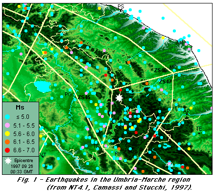
The Umbria-Marche Apennines are a seismic area, the activity of which is
not uniform. According to the seismogenic model of GNDT (release ZS 4.0, 1996, from
Scandone et al., 1990), this area belongs to several seismogenic zones.
According to the Italian parametric earthquake catalogue NT4.1 (Camassi and
Stucchi, 1997), the most active of them are zones 45, 46 and 47 (Fig. 1).
These zones are part of the axial belt of the Apennine chain, which is
characterized by mainly NW-SE to N-S trending normal and oblique faults, whose
activity is generally highlighted by the displacement of Late
Pleistocene-Holocene deposits and landforms.
The epicentres of the earthquakes of Septembre and October 1997 belong to the
zone 47 and are located in the area between Serravalle del Chienti, Foligno and
Nocera; this area shows a seismic activity lower than the one of Alta Val
Nerina.
From the tectonic point of view the epicentral area of these earthquakes is
characterized by the presence of two primary faults (Colfiorito and Cesi
faults, NW-SE to N-S trending, see Pizzi, 1992 and Cello et al., 1997), which
border to the east the Colfiorito and the Cesi basin, and are 7.5 km e 6 km
long respectively.
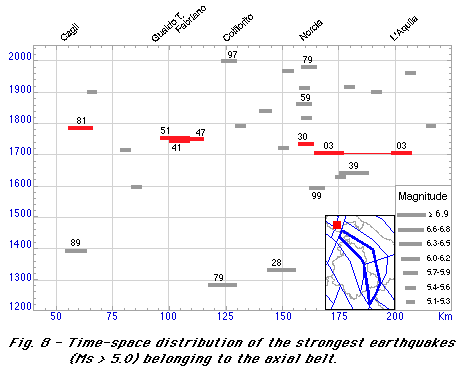
In this area, the following earthquakes with Ms >= 5.0 are located
The magnitude of the last two events is too low to infer the faults which might
be responsible for them on the basis of geological data.
Slightly at SE a few more earthquakes are located:
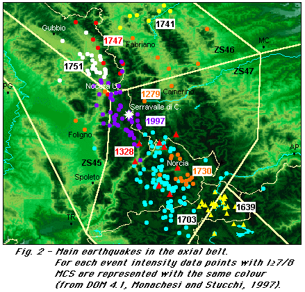
It shows that the source of the earthquakes of September/October 1997 is located in an area which did not release strong earthquakes since 1279 at least. In this case the fault responsible for the 1997 earthquakes may be the same of that responsible for the 1279 event and the recurrence time for the re-activation of this fault may be at least 700 years, or even larger if the earthquake of 1279 was generated by other faults.
Time distribution of the strong earthquakes
The time distribution of the seimic activity in the Umbria-Marche
Apennines is far from being stationary. Fig. 3 shows the time sequence of the
events which belong to seismogenic zones 45, 46, 47.
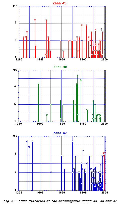
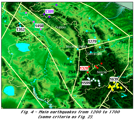
The destructive earthquakes of 1279, (Monachesi, 1987), 1328,
(Monachesi, 1987), 1352 e 1389, epicentral area Alta Val Tiberina
(Castelli et al., 1996) were followed by a period of moderate activity, with a
small number of destructive earthquakes over 250 or even 350 years:
1458, Alta Val Tiberina (Castelli et al., 1996); 1599, Cascia
(GNDT, 1994); the earthquakes of 1639 near Amatrice (Monachesi and
Castelli, 1992) might also belong to zone 47 (Fig. 4). Studies on these
earthquakes are also found in Boschi et al. (1995 & 1997).
This period of moderate (assuming that catalogues are complete) activity was
suddenly interrupted at the beginning of 18th century by the strong earthquakes
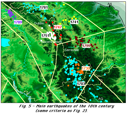
of Norcia and L'Aquila of 1703, followed by a century of destructive
earthquakes. Actually, in this century ten heavy damaging earthquakes (7/8
<= Imax <= 8 MCS) and eight destructive events (Imax >= 8/9 MCS) took
place in this area (Fig. 5). Their parameters, as supplied by the catalogues
NT4.1 (Camassi e Stucchi, 1997) and CFTI (Boschi et al., 1997), are:
	year      epic.area                Imax(NT)     Imax(CFTI)      Ms(NT)      Me(CFTI)
	1703      Norcia/L'Aquila          10           11              6.7         6.7
	1730      Norcia                   9            9               5.9         6.3
	1741      Fabrianese               9            9               6.2         6.2
	1747      Fiuminata/Gualdo T.      9            8/9             6.2         5.7
	1751      Gualdo Tadino            10           10              6.7         6.2
	1781      Cagliese                 10           10              6.7         6.1
	1789      Alta Val Tiberina        8/9          10              5.9         5.7
	1799      Camerino                 9            9/10            6.2         5.9
Studies on these earthquakes are found in: Stucchi (1985), Pergalani et al. (1985) Monachesi (1987), Conversini et al. (1990), Postpischl, ed. (1990), Stucchi et al. (1991), Castelli et al. (1996), Boschi et al. (1995 & 1997).
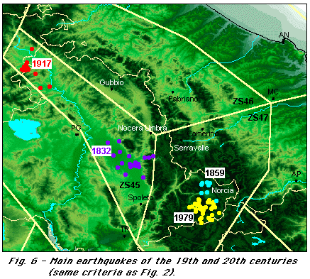
In the next two centuries (19th and 20th) the seismic acivity was high, though it did not reach the level of 18th century. A few destructive earthquakes (Fig. 6): 1832, Foligno (Monachesi, 1987); 1859, Norcia (GNDT, 1994); 1917, Alta Val Tiberina (Castelli et al., 1996); 1979, Norcia/Cascia (Spadea et al., 1981), and about ten heavy damaging earthquakes are reported. Studies on these earthquakes are also found in Boschi et al. (1995 & 1997).
Some elements of active tectonics
The key events of this sequence are the earthquakes which affected the
Norcia and L'Aquila basins in 1703 (Monachesi et al., 1987, Boschi et al.,
1995). Proceeding from South to North there are few doubts that the earthquake
which struck the city of L'Aquila on February 2nd, 1703 is related to the
activity of the two fault-branches which affect the eastern border of the
Aterno river valley-L'Aquila basin, that is the Mt. Marine and Mt. Pettino
fault-branches (8.5 km and 9.5 km long respectively). These faults are
responsible for the displacement of Late Pleistocene slope deposits and for the
formation of impressive carbonate bedrock scarps (Blumetti, 1995, Galadini et
al., 1997).
The Norcia area is another typical fault-bound intermontane basin of the
Central Apennines (Blumetti et al., 1992). The main Quaternary faults, located
along the eastern and western borders of the basin, are responsible for the
displacement of Middle Pleistocene alluvial deposits. By contrast, the Cascia
basin, affected by the 1599 earthquake, is characterised by a NW-SE normal
fault which border the basin to the NE (Cello et al., 1997); along this fault
Blumetti (1995) reports geological effects related to the 1703 earthquake.
More work has to be done before having a clear tectonic framework of the
earthquakes which have affected the Alta val Nerina, including the earthquake
of 1328.
In the case of the Gualdo Tadino basin (1751 earthquake) some data are
available from an unpublished map of Bosi et al. (1983). In this map some
geomorphological features are reported (such as fault scarps) which highlight
that the Gualdo Tadino basin is another typical intermontane depression of the
Central Apennines, bound by a Quaternary fault to the east. Finally, more work
has to be carried out in order to explain the seismicity of Alta Val Tiberina
(Sansepolcro, Città di Castello) and Cagli, with reference to the
earthquakes of 1389, 1789 and 1781 respectively.
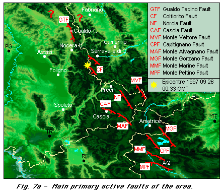
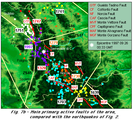
Fig. 7a presents some primary active faults of the area, as compiled from Blumetti (1995), Pizzi (1992), Cello et al. (1997), Galadini et al. (1997) and unpublished data by A. Basili, F. Galadini, P. Galli, P. Messina. Fig. 7b compare these faults with the earthquake data of Fig. 2.
References
Blumetti A.M., 1995. Neotectonic investigations and
evidence of paleoseismicity in the epicentral area of the January-February
1703, Central Italy, earthquakes. Ass. of Eng. Geologists, spec.
publ. no. 6, 83-100.
Blumetti A.M., Coltorti M., Dramis F., 1992. Evoluzione
geomorfologica dell'area nursina. Guida all'escursione del 7-7-1992
nell'Appennino umbro-marchigiano (aree di Norcia e Casteluccio),
14-30.
Boschi E., Ferrari G., Gasperini P., Guidoboni E.,
Smriglio G. e Valensise G. (eds.), 1995. Catalogo dei forti terremoti
in Italia dal 461 a.C. al 1980. ING-SGA, Bologna, 970 pp.
Boschi E., Guidoboni E., Ferrari G., Valensise G.
e Gasperini P. (eds.), 1997. Catalogo dei forti terremoti in Italia
dal 461 a.C. al 1990, 2. ING-SGA, Bologna, 644 pp.
Bosi C., Coltorti M., Dramis F., 1983. Carta del
Quaternario della conca di Gualdo Tadino (tra Fossato di Vico
e Rigali ). Unpublished map.
Camassi and Stucchi, 1997. NT4.1, a parametric catalogue
of damaging earthquakes in the Italian area (release NT4.1.1).
GNDT, Milano, 66 + XXVII pp. (Internet, /NT/home.html)
Castelli V., Monachesi G., Moroni A. e Stucchi M.
(eds.), 1996. I terremoti toscani dall'anno 1000 al 1880: schede
sintetiche. GNDT, rapporto interno, Macerata-Milano, 314 pp.
Cello G., Mazzoli S., Tondi E., Turco E., 1997. Active
tectonics in the central Apennines and possible implications for
seismic hazard analysis in peninsular Italy. Tectonophysics, 272,
43-68.
Conversini P., Lolli O., Molin D., Paciello A. e
Pagliacci S., 1990. Ricerche sulla sismicità storica della
provincia di Perugia. Quaderni Regione dell'Umbria, Collana Sismica,
Perugia, vol. 1b, 56 pp.
Galadini F., Messina P., Basili R.e Bosi C., 1997.
Faglie attive nell'Appennino centro-meridionale. Gruppo Nazionale
per la Difesa dai Terremoti, General Assembly, 41-44 (extended
abstract).
GNDT, 1994. Studi di terremoti attraverso i repertori
sismologici e le loro fonti, UR Macerata. Archivio macrosismico
del GNDT, Milano.
GNDT, 1995. Studi preliminari di terremoti attraversio i repertori
sismologici. Archivio macrosismico del GNDT, Milano.
Monachesi G. (ed.), 1987. Revisione della sismicità
di riferimento per i comuni di Cerreto d'Esi (AN), Esanatoglia
(MC), Serra San Quirico (AN). Osservatorio Geofisico Sperimentale,
Macerata, rapporto interno, 240 pp.
Monachesi G. e Castelli V. (eds.), 1992. Sismicità
dell'area aquilano-teramana dall'"analisi attraverso i cataloghi".
Rapporto tecnico per la Regione Abruzzo, Osservatorio Geofisico
Sperimentale, Macerata, 245 pp.
Monachesi and Stucchi, 1997. DOM4.1, an intensity
database of damaging earthquakes in the Italian area. Internet,
http://emidius.irrs.mi.cnr.it/DOM/home.html)
Nostro C., Cocco M. e Belardinelli M.E., 1996. Static
stress change in extensional regime:
an application to southern Apeninnes. Bull. Seism.
Soc. Am. [in stampa]
Pergalani F., Monachesi G., Stucchi M., 1985. The
Camerino earthquake of July 28, 1799. In: D. Postpischl (ed.),
Atlas of Isoseismal Maps of Italian Earthquakes, Quad. Ric. Scien.,
114, pp. 70-71.
Pizzi A., 1992.. Faglie recenti ed attive e origine
delle depressioni tettoniche. Esempi dall'Appennino umbro-marchigiano.
Tesio di dottorato, Università di Camerino.
Postpischl D. (ed.), 1990. Valutazione del rischio
sismico per il territorio della Repubblica di San Marino. Fase
1. Ist. di Topografia, Geodesia e Geofisica Mineraria, Università
di Bologna, RPT/TGGM/1/90, 826 pp.
Scandone P., Patacca E., Meletti C., Bellatalla M., Perilli N. e Santini
U., 1990. Struttura geologica, evoluzione cinematica e schema
sismotettonico della penisola italiana. Atti del Convegno Annuale del
Gruppo Nazionale per la Difesa dai Terremoti, vol.1, p. 119-135.
Spadea M.C., Favali P., Giovani L. e Vecchi M., 1981.
Indagine macrosismica sul terremoto di Norcia del 19.9.1979. In:
Intervento a seguito del terremoto di Norcia del 1979, CNR/PFG,
Roma, pubbl. 350, pp. 47-57.
Stucchi M., 1985. The earthquakes in Central Italy,
January-February 1703. Some questions, some preliminary answers.
In: D. Postpischl (ed.), Atlas of Isoseismal Maps of Italian Earthquakes,
Quad. Ric. Scien., 114, pp. 56-57.
Stucchi M., Monachesi G.e Mandrelli F.M., 1991. Investigation on XVIII century seismicity in Central Italy in the light of the 1741, Fabriano earthquake. In: M. Stucchi, D. Postpischl, D. Slejko (eds.), Investigation on Historical Earthquakes in Europe. Tectonophysics, 193, pp. 65-82.