|
|
[Deliverables and queries] [Presentation] [Homepage] |
Introduction
In the period 1427-1428 there was a series of
earthquakes in the Eastern Pyrenees that caused considerable damage over
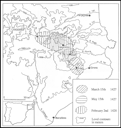
an extensive area of Catalonia (Fig. 1). These are spme of the most destructive
known earthquakes in the whole Pyrenees, so their study is of great importance
for the determination of the seismic risk, not only in the epicentral region
but also in the main part of the North-East of the Iberian Peninsula and
the South of France. This interest is all the more so given the existence
in these regions of relatively important towns, tourist centres, industrial
installations including large dams and hydro-electric stations, as well as
other transport and communications infrastructures. The fact that the
instrumental seismicity being observed at present is moderate also bolsters
the interest in the historical study in this region.
Within the framework of the project of the CEC
Review of Historical Seismicity in Europe (RHISE) much effort has
been put into documentary research in archives and libraries, making a critical
analysis of the known sources - basically compiled in the catalogue of
Fontserè and Iglésies (1971) - and searching for new ones in
order to calibrate, extend and, if necessary, to modify the knowledge already
existent about these earthquakes.
A preliminary result of the above-mentioned
research shows (Fig. 1) a map of the areas most affected by the three quakes
in the series, dated 15th March 1427, 15th May 1427, and 2nd February 1428
(Olivera et al., 1990).
It is not the aim of this report to make a synthesis
of the current state of the intensive study in course of the seismic series
1427-1428, but to present the results of an ecclesiastical documentary source
which up to now has scarcely
been explored. We refer to the Pastoral Visits,
documents which resulted from the journey which the Bishop or his representative
made around the churches, chapels and convents of his diocese, taking note
of the state they were at the time of the visit.
The Pastoral Visit of the Diocese of Girona
of 1432 contains, as shown in this study, extremely valuable information
about the effects of the earthquakes which had occurred four and five years
previously. It is clear that one of the main drawbacks of this document lies
in the impossibility of separating the effects of the different earthquakes
of the series. The description in the visit of the state of the different
buildings must be seen as the result of the different earthquakes superimposed
one on top of the previous one and thus only constitutes a source which
complements the direct accounts, regarding each earthquake in the series,
which are obtained from other types of information. In spite of this serious
drawback the big advantage of this source is the high number of places that
correspond and the detail and precision of the descriptions contained which
allow a fairly reliable classification of the degrees of damage.
None of the published seismic catalogues include
references to this visit. Prades (1989) publishes a study that points out
the interest of this source for the study of earthquakes and carries out
an initial analysis, expressing the results in a map in which three different
degrees of damage are given. In the complete extraction we have made of the
same source the number of points has increased and unlike the above mentioned
author we have included the negative information, that is to say those places
in which no damage is known to have been observed. This negative information
is of as great an interest as the positive, as in some cases it allows us
to give an adequate value to information coming from other sources and helps
to limit the areas of significant damage of the different earthquakes.
Historical Context
The Catalan-Aragonese Crown in the 15th
century
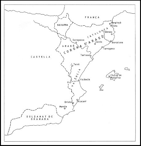
The territories of the Catalan-Aragonese Crown
(Fig. 2) are situated in the North-East of the Iberian Peninsula.
The history of the Crown in the 15th century
is renowned for the introduction of the castillian dynasty of the
Trastámara with whom some historians have associated, as it coincides
with the collapse of the House of Barcelona, with the beginning of the decline
of Catalonia.
From an internal point of view this is a century
full of conflicts and tensions, with the rise of the peasants' revolt against
the power of the nobility, all this occurring against a background of economic,
demographic and agrarian crisis.
The diocese of Girona around 1430
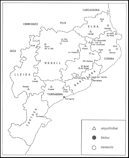
Fig. 3 shows the episcopal divisions in Catalonia
in the Middle Ages (13th -16th centuries). The diocese of Girona, situated
in the North-East of Catalonia, is one of the oldest of the Iberian Peninsula:
it was created in the 4th Century, during the Early Roman Empire. The musulman
invasion interrupted its operation between 720 and 785. The boundaries of
the diocese were to remain unaltered until 1957.
The organization of
land.
We do not have documents showing the exact boundaries of the Bishopric of
Girona until 1115. They enclose an area of some 4,990 square kilometers.
The Bishopric of Girona (Fig. 3) had a common boundary as today, with Elna
to the North, Vic to the West, Barcelona to the South and the sea to the
East.
The territory of the bishopric of Girona coincides
almost exactly with the vegueries (administrative, judicial and military
districts, entrusted to a public official who depended directly on the Attorney
General of Catalonia) of Girona-Besalu and Camprodon. The operation of the
feudal system in which the ownership of land could provide the occupant with
certain public advantages above the other farmers, created in the administrative
divisions a dense network of senyorius (territory under the influence
of a noble who could administer civil, and more rarely, criminal justice,
levy taxes, appoint officials and representatives of the noble's authority,
maintain law and order, issue letters of settlement - special local statutes
- and requisit military
duties). The working of each of these institutions
generated a great deal of documentation, a significant part of which has
been lost or has been incorporated, through marriage or inheritance, into
the family archives throughout the Iberian peninsula, areas where it is difficult
for researchers to gain access to. The search for written evidence regarding
the seismic activity which occurred during the Early Middle Ages in the bishopric
of Girona cannot be confined to royal and municipal documentation, but has
to include that of the ecclesiastics and the nobility although these may
be a lot less accessible.
Population and settlement.
It is not an easy task to determine the number and the spatial distribution
of the people settled in a specific data of the Middle Ages, in any region
of the Principality due to the lack of suitable documentation. The only sources
that indirectly contribute quantitative information about the Catalan population
are of a fiscal nature: the fogatges (relation of homes subject to
the payment of taxes according to localities, townships and superior
demarcations), talles (relation of the heads of households of a locality
drawn up in order to distribute a tax) and estims (relation of the
goods of each family limited to one locality drawn up to distribute a tax).
From the fogatges immediately previous to the period which concerns
us, i.e. 1378, it has been learnt that in the diocese of Girona there were
about 15,991 focs (homes subject to the payment of taxes; it is
conventionally admitted that the "foc" was made up of 4 or 5 people
in the 15th Century which were fiscally solvent). The population with few
resources were disregarded by the study.
The population was concentrated in the Lowlands:
some 70% of the fiscal focs are situated in the coastal plains of
the Empordans, in the middle valleys of the Ter and the Fluvià and
their respective tributaries and in the area surrounding Lake Banyoles. These
form concentrated nuclei of some 20 families. In the mountain regions, where
the human presence was scarce, on the contrary there was a predominance of
dispersed settlements; the people were spread out among a few villages, a
long way from one another and a great number of parishes made up of a group
of isolated farmhouses, normally about 10 in number.
The socio-economic context.
The earthquakes occurred in a period of economic and demographic stagnation
and of social tension, at least in the majority of the rural regions of Old
Catalonia, those situated to the north of the Llobregat. The Plague in 1348
had caused a high mortality rate throughout the Principality. The resurgences
of the epidemic and the poor harvests, occurring among a population that
lived from one day to the next and was short of savings, held up the recovery
from the demographic decline. The noblemen tried to neutralize the loss of
workforce and the fall in their incomes by arbitrarily increasing the economic
and labour demands on the peasants and by restricting their freedom of movement
to prevent them from fleeing to the towns or to other regions. The countrymen
for their part try to capitalize on the revaluation of work in the fields
as a result of the sudden contraction of supply; they want to be able to
dispose freely of the land and property as well as of their own person and
they want to obtain their freedom without loosing the mas (agrarian
holding of a family nature endowed with fields for cultivation, wasteland
and pastures and dwelling).
Their aim is to change from being a slave tied
to the land to free tenant of the land they cultivate. The Crown takes advantage
of the agrarian dispute, with the support of the peasants, to weaken the
power of the nobility and to recover the "senyorius" that it had to
sell or to pledge in the times of most acute economic difficulties. The peasants,
in order to attain their objectives, and with the consent of the sovereign,
organize themselves in syndicates. The aristocracy and the high clergy use
their over representation in the Corts Catalanes to neutralize the agreement
of the monarch with the peasants. The tension explodes in the form of local
uprisings. The struggle impoverishes the peasants especially those who live
in the mountain regions of Old Catalonia.
By 1425 the situation became particularly serious
in the area where the earthquakes of 1427 and 1428 occurred, which suffered
a strong depopulation. Consequently this area was going through an adverse
economic climate which the quakes, by taking human lives, causing some of
the survivors to flee, damaging the infrastructure and destroying economic
resources, did not exactly help to redress. The delay of those affected in
getting back to normal can be ascribed as much to the unquestionable magnitude
of the destruction as to the previous lack of savings and perhaps of positive
vision of their own future.
Pastoral Visits
Pastoral Visits in medieval
Catalonia
The Pastoral Visits form without doubt one of
the most suitable means of ecclesiastical documentation for the studies of
historical seismicity. Every three or four years the Bishop or his representative
went around the parishes of his diocese, at a rate of one or two a day, in
order to be informed in situ of their situation and with knowledge
of cause to adopt appropriate measures. The records of these regular inspections
consist of two very distinct parts: the visitatio hominum (visit of
the people) a survey of the conduct of the parish clergy and his parishioners,
and the visitatio rerum (visit of the things), an extremely thorough
report regarding the state of conservation of the church, the rectory, the
cemetery and other religious properties (monasteries, chapels, hermitages,
etc.) as well as of the books, liturgical wardrobe and other religious "gear"
(chalices, relics, lamps etc.). While the visitors in the 14th Century gave
more importance to the moral aspects, those in the 15th Century, for reasons
as yet unclarified, tended to concentrate their attention on the material
infrastructure of the parish clergy's work and showed more interest in the
things than in the people. The Pastoral Visit, around 1400, from being an
investigation of the conduct of the clergymen and laymen, turned into an
inventory of churches and liturgical objects.
The visitatio rerum, especially in the
15th Century, a century of great seismic activity in Catalonia, constitute,
as a result of the care with which they were recorded, an important store
of precise and reliable information about the effects of the earthquakes
and other cataclysms, beyond the above-mentioned properties, many of them
small rural buildings almost absent from the documentation of the civil
administration. The analysis can achieve high degrees of precision in those
very few cases where visits close to the earthquakes were maintained, one
before and one after the event.
The catalan ecclesiastical archives maintain
a wide range of Pastoral Visits, eighty for the Middle Ages. The earliest
date from the beginning of the 14th Century. Geographically they are not
so well distributed: there are available 28 in Barcelona, a few others in
Girona, 15 in Vic, 8 for Urgell and one in Tortosa, whereas none has been
kept for Tarragona nor for Lleida for the years before 1500. The dioceses
located to the North of the Llobregat, in the "Old" Catalonia, however, are
those that contribute practically all the information, which is particularly
favourable considering that they are the areas where the earthquakes were
the most intense and frequent.
The visit to the Diocese of Girona in
1432
It is a report of a visit (Llibre de Visites
Pastorals, 1432) immediately following the most critical phase of the seismic
series; among all the affected dioceses which are available it is the only
one useful for the investigation of the earthquakes of 1427-28, since the
others correspond to periods previous to or too long after the seismic crises.
It is written in Latin, it is composed of 295 sheets written on both sides,
and its state of conservation is good. It was drawn up, on the orders of
the Bishop Joan de Casanova, by the visitor Pere Joan, between the 3rd August
and 15th December 1432. It concerns a special visit; more than 400 ecclesiastical
properties examined, which is an unparalleled number for the Visits in the
Middle Ages. It arises from the eagerness of the Bishop to ascertain precisely
the damage caused by the latest earthquakes to the ecclesiastical
properties.
The visitor notes down in great detail, parish
by parish, the noticeable effects that the earthquakes had caused to the
ecclesiastical buildings. From the whole range of these notes groups of different
categories of damage can be distinguished. In order to grasp the wealth and
quality of the information contributed by the visit, the following transcriptions
are reproduced, the first one corresponding to a completely devastated monastery
and the second one to a partially destroyed church:
Reperit dictum monasterium
(Santa Maria d'Amer) et
ecclesiameiusdem totaliter distructum et distructam, propter terremotum
(the above mentioned monastery and its church were found totally destroyed
as a result of the earthquake).
Invenit dictam ecclesiam
(Sant Cristòfol dels Horts)
in quadam sua parte postrata per terremotum (the above mentioned church
was found, a part of which collapsed as a result of the earthquake).
Analysis of the Pastoral Visit
Methodology
The analysis of the Pastoral Visit to the diocese
of Girona of 1432 has allowed us to classify the information obtained according
to the following criteria (Fig. 4):
A) buildings completely devastated by the
earthquakes;
B) buildings destroyed in a very large
proportion;
C) buildings partially destroyed;
D) buildings which had suffered some form of
slight damage;
N) buildings in which there were no noticeable
effects.
An important problem has been to determine the
geographical location of the buildings reported in the Visit. For this purpose
it has been of great help the work of Gavin (1978-1991). It consists of a
photographic record, published in different volumes, each one containing
an inventory of the churches and convents of one or two regions, including
geographical coordinates. Each volume is accompanied by very useful indices
that have helped us in the task of identifying the toponymy. Obviously Gavin's
work does not account for 100% of the churches with the original toponymy
of the Pastoral Visit. In order to situate the remaining buildings we have
resorted to the Gran Geografia Comarcal de Catalunya (1981). This
work, at least the volumes that have been consultedm for this study, do not
have an index of churches as in the case of Gavin, but includes some
complementary indices of the names of municipalities and villages. In this
way we have been able to identify and locate the churches the name of which
was accompanied by a toponym or we knew the municipality in which it could
be found.
By consulting these two publications we have
managed to locate 360 points, that is 93% of the buildings quoted in our
original source of information, the Pastoral Visits.
Results
The effects of the earthquakes on the buildings
reported in the Pastoral Visit have been coded according to the criteria
explained above. For the moment we are keeping to this particular classification,
and we are not going to assign a degree of intensity by using any of the
usual scales because of the great difficulty and uncertainty that this entails
and because of the need to approach the data of the Visit with information
coming from other sources.
Of a total of 387 places analyzed, 50 (13 %)
correspond to churches or latria (ecclesiastical buildings) completely or
mainly destroyed (categories A and B considered together); 264 (68%) buildings
were not affected (category N).
These results are shown in Fig. 4, which presents
the effects on the constructions using symbols of different gray shades for
the above described damage categories.
Given the time of these earthquakes the wide
spread and the concentration of the information available are remarkable.
It must be pointed out that the main concentration of buildings destroyed
occurs in an extended area in an
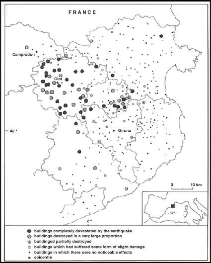
approximately SE-NW direction, which runs from
Amer as far as approximately 10 km NW of Olot, half way between Olot and
Camprodon. These data agree with the information existing from other documentary
sources of the earthquakes of 1427, as can be seen by comparing Fig. 1 and
4.
These results are shown on the map of Fig. 4,
which shows another area with a certain number of points of destruction at
a distance of between approximately 10 and 20 km to the North of Girona.
In principle this is to be contrasted with the absence of data about the
effects in this region which arises from other archive documentation consulted
up to now; this is something that will have to be analyzed in detail.
There are no points which correspond to destruction
far from the two areas previously mentioned. What can be found are a few
relatively isolated places where damage is described which in some cases
could be due to local effects.
Summary and Conclusions
In this study we have carried out an extraction,
translation and analysis of the original Latin text of the Pastoral Visit
to the Diocese of Girona in 1432. This is a source of exceptional interest
for the study of the seismic series 1427-28, as it contains detailed information
of the state of 387 churches and other ecclesiastical buildings at the time
of the Visit.
Starting from the descriptions contained in
the Visit we have identified the different buildings and classified them
according to five categories of effects: buildings completely devastated
by the earthquakes, buildings destroyed in a very large proportion, buildings
partially destroyed, buildings that had suffered some form of slight damage,
and buildings in which there were no noticeable effects. The results of this
analysis are shown in Fig. 4.
As the Visit was carried out in 1432, the effects
classified in this way cannot be directly attributed to a particular earthquake,
but in principle have to be considered to be the accumulated effects of the
1427-28 series, and can thus only be analyzed together with all the information
available from other sources which are still being investigated. We have
taken care to include all the negative information, i. e. that which corresponds
to buildings not
affected (by any of the earthquakes). This will
be of great help in defining the areas of damage from the different
earthquakes.
An initial global analysis of the data of the
Pastoral Visits together with that from other different sources, suggests
the presence of significant local effects. Nevertheless this can only be
described after a detailed study of all the information which will be made
available by the current research.
References
Fontserè, E. i Iglesies, J., 1971.
Recopilació de dades sísmiques de les terres catalanes entre
1100 i 1906. Fundació Salvador Vives Casajuana, Barcelona, 547 pp.
Gavin, J.M., 1978-1991. Inventari
d'Esglèsies. Vols. 4, 11, 13, 14, 24. Artestudi, Barcelona. Gran Geografia
Comarcal de Catalunya, 1981. Fundació Enciclopèdia Catalana,
Barcelona.
Llibre de Visites Pastorals, 1432. Arxiu
Diocesà de Girona, P.19, 590 pp.
Gran Geografia Comarcal de Catalunya, 1981.
Fundació Enciclopèdia Catalana, Barcelona.
Llibre de Visites Pastorals, 1432. Arxiu
Diocesà de Girona, P.19, 590 pp.
Olivera, C., Riera, A. and Roca, A., 1990.
Study of the 1427 earthquakes in Catalonia. Proc. XXII General Assembly European
Seismological Commission, In: A. Roca and D. Mayer-Rosa (Editors), Proc.
XXII ESC General Assembly and activity report 1988-1990, Barcelona, 17-22
September 1990, I, pp. 327-331.
Prades, I., 1989. Els terratrèmols
de la sèrie olotina i el cas de la vila d'Amer, Quaderns de la Selva,
2 (Sta. Coloma de Farners, s.d.), 103-112.
[Top]
[Vol.1]
[Vol.2]
[Deliverables and queries]
[Presentation]
[Homepage]