
EC project "Review of Historical Seismicity
in Europe" (RHISE) 1989-1993
|
|
[Deliverables and queries] [Presentation] [Homepage] |
Introduction
Transfrontier earthquakes are often treated
in different ways by the sides of the boundary. Moreover, researchers dealing
with the same earthquake sometimes propose different solutions. As it is
known, the result depends on the quality of the primary description set (its
completeness or the reliability of the individual records), on one hand;
on the criteria chosen for the assessments and analysis, on the other.
This study concerns a typical historical earthquake,
felt within the territory of several countries: Bulgaria, Romania, Bessarabia,
Ukraine, Turkey, Serbia, Transylvania. This earthquake occurred in 1892,
when regular seismological observations on the Balkan Peninsula had started,
and it has been more than once a matter of study. The most widely spread
information about the event is that from the catalogue of Balkan earthquakes
(Shebalin et al., 1974):
- 1892, Oct. 14, 05 h. (GMT): epicentre? Black
Sea? Imax = 8 (MSK) at Ignatievo (Bulgaria); felt in Bulgaria, SE Romania,
Istanbul;
- 1892, Oct. 14 , 06 h. 54 min. (GMT): 43.3°
N, 27.6° E; Io = 8 (MSK).
Were the earthquakes two? Where was the epicentre?
As it can be seen, a final indisputable decision is still lacking.
The purpose of the present research is, after
the analysis of the studies concerned with this event, to draw a final conclusion
on the basis of a new assessment of the available descriptions.
Available sources and previous solutions
According to the first piece of news of both
the Romanian Meteorological Institute (Hepites, 1894) and the Central
Meteorological Institute of Bulgaria (Watzof, 1902), there was only one strong
earthquake on 14 October 1892 in Central Balkans.
The shock was felt at Sofia (Bulgaria) and Bucharest
(Romania) at 06 h. 54 min. Eastern Europe time, i.e. at 04 h. 54 min. GMT
(+/- 2 min.). However, the second information in the Balkan catalogue (Shebalin
et al., 1974) came from the manuscript of Grigorova (1973), who gave it according
to the "local time" system without transferring it into UT. Thus, this paper
is related to the October 14th, 1892 earthquake which occurred at 04 h. 54
min. GMT.
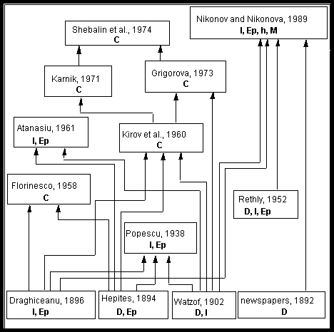
The bibliography concerning the 1892 earthquake
could be classified as follows: primary descriptions with intensity assessments;
primary descriptions without intensity estimation but containing an attempt
for epicentre determination; a complete analysis of the event; parametric
catalogues. This classification together with the "family-tree" of the available
sources of information is shown in Fig. 1.
The sources containing primary data lie at the
bottom of the "tree". Among those sources some slight mutuality is noticed.
Specifically, Hepites (1894) besides the Romanian reports gave only a piece
of Watzof's information about the felt area extension over Bulgaria; Draghiceanu
(1896) supplied some data from Austro-Hungary (Transilvania) to the compilation
of Hepites, and proposed an epicentre also. Draghiceanu outlined for the
first time the territory shaken by the earthquake. He proposed also the earliest
assessments of intensity for some areas of Romania. Watzof (1902) collected
reports from Bulgaria of that time; he assessed the intensity in some localities
and mentioned that the event was felt in Bucharest, too.
In the course of time several studies on the
1892 earthquake appeared. Their authors used the primary information partly,
like Florinesco (1958) and Atanasiu (1961), or completely, like Popescu (1938)
and Kirov et al. (1960). During the last three or more decades the publications
are rarely based on the original reports.
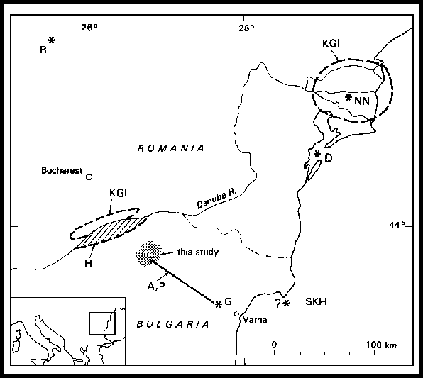
How was the main question about the epicentre
location solved? The individual solutions are described in Tab. 1 and Fig.
2. They point to two main epicentral areas: the delta of Danube river (Romania)
or the north-eastern part of Bulgaria. As far as the "other solutions" (Tab.
1) are concerned, Rethly (1952) made his decision from too scanty information
- 4 reports from Transilvania, and Florinesco (1958) didn't take courage
to specify the epicentre on the basis of an incomplete dataset, from Romania
only.
What kind of approach brought to each of the
main solutions indicating two epicentre locations with a distance of more
than 200 km in between?
Draghiceanu (1896), as mentioned previously,
on the basis of the initial reports of the Romanian Meteorological Institute
(Hepites, 1894) made some intensity assessments and outlined two kinds of
areas: the "felt area" and the area shaken by an intensity of 6 and higher.
For unknown reasons he excluded from the strongly shaken area some localities
of intensity higher than 6. Unfortunately, he did not know what intensity
the effects within the neighbouring Bulgarian territory had reached. Finally,
Draghiceanu identified the epicentre in the very eastern part of the inner
area and, at the same time, at a place far from the centre of the felt area.
One of the solutions of Kirov et al. (1960) - that in the area of the Danube
delta - is obviously influenced by the earlier decision of Draghiceanu.
Recently, one more determination was published
about the earthquake epicentre in the Danube delta area (Nikonov and Nikonova,
1989). The authors announced that they have reassessed "all raw
materials" from Romania and Bulgaria pointing to Draghiceanu (1896) and
Watzof (1902).
Irrespective of our opinion about the interpretation
of Draghiceanu (see above), the use of that source as a primary one is
disputable. The paper of Draghiceanu is a second-hand source containing the
author's intensity assessments and some generalised descriptions only. We
do not agree with Nikonov's assessments of intensity in Bulgaria, which by
the way do not correspond to either Watzof's intensities or the original
descriptions in Watzof (1902). Finally, in the paper of Nikonov and Nikonova
the isoseismal configuration does not seem in agreement with the general
tendency of the macroseismic field.
The epicentral area was supposed in the
north-eastern Bulgaria for the first time by Hepites (1894). In the immediate
vicinity, in the Romanian territory, a possible epicentral area was mentioned
in the catalogue of Kirov et al. (1960). However, a detailed analysis was
not made in those publications.
A substantial search for the epicentre location
was carried out by Popescu (1938). He assessed intensity to 10 Romanian
localities using Hepites' compilation. After that he picked up 8 points of
the greatest intensity from Watzof's table for Bulgaria. On the basis of
the resulting set of epicentral data points, Popescu concluded that the
epicentral area was in NE Bulgaria. Although the conclusion drawn was quite
acceptable, his approach to data processing was incorrect: he dealt with
intensity assessments of various authors without reducing them to the same
scale.
Atanasiu (1961) gave intensity values on the
basis of the materials gathered by Hepites for those Romanian localities
where he considered the assessment as a good one. Hepites' data were used
as a whole for the first time. Atanasiu drew up also all the isoseismals
within the Romanian territory by using the technique of detailization. He
completed his own investigation by using some selected data points from NE
Bulgaria (Watzof's assessments, 1902) as well. Juxtaposing the two macroseismic
scales applied (MCS and RF), he assessed an intensity of approximately 8
MCS to the epicentral area which, in his view, was situated along the line
Isperich-Ignatievo in Bulgaria. One can be somewhat surprised by his isoseismal
map: the 5 MCS isoseismal coming from Romania outlines data points of at
least 7 RF on the Bulgarian territory.
|
NE Bulgaria - Hepites, 1894 (H): "The earthquake centre was out of our country (Romania), perhaps at the state boundary ... towards the Danube river, between the towns Calarasi and Oltenita. It was located very deeply, obviously". - Popescu, 1938 (P): epicentre in the NE part of Bulgaria. - Atanasiu, 1961 (A): the epicentre along the line Isperich-Ignatievo (NE Bulgaria); Imax = 8 MCS. - Grigorova, 1973 (G): epicentre at Ignatievo (East Bulgaria), 43.3° N, 27.6° E; Io = 8 MSK. - Shebalin et al., 1974 (SKH): determination taken from Grigorova. |
|
Danube delta (Romania) - Draghiceanu, 1896 (D): epicentre near the Danube delta (at Lake Sinoe). - Kirov et al., 1960 (KGI): one of the possible epicentres was assumed at the Danube delta; "a deep source, probably". - Nikonov and Nikonova, 1989 (N N): epicentre at 45.1° N, 29.5° E; Imax = 7-8 MSK. |
|
Other locations - Rethly, 1952 (R): epicentre at 45°39' N, 25°36' E (Brasov/Transylvania). - Florinesco, 1958: "Epicentre probably in the Balkan Peninsula". - Kirov et al., 1960 (KGI): the second location is on the line between Oltenita and Giurgiu (Romania); "a deep source probably". - Karnik, 1971: "epicentre? Black Sea? Imax = 8 MSK"; reference to KGI; included in SKH as unknown epicentre. |
Grigorova (1973), due to unpublished reasons,
located the epicentre at the village of Ignatievo, which is situated in the
SE part of the epicentral area identified by Watzof, Popescu and Atanasiu.
This decision, namely, together with the Karnik's one (1971), was incorporated
in the catalogue of earthquakes of the Balkan area (Shebalin et al., 1974).
Following this analysis, the Atanasiu's work
might be delineated as the most complete and reliable one among the studies
on the 1892 earthquake.
A new epicentral location
What should have been avoided in processing
the data, was emphasised in the previous part of the study.
We are proceeding here to the final point: the
search for a new solution. In order to get to the announced purpose, a list
of some recommended steps of the procedure has been compiled. Ordinarily
enough, these stages are: to choose the sources of information among the
first-hand ones; to evaluate the seismic intensity from all the selected
descriptions according to one and the same scale; to compile an isoseismal
map and to derive possible earthquake parameters from it.
The compilations of Hepites (1894) and Watzof
(1902) were chosen as first-hand sources of reports for the areas of moderate
and significant effects. For the felt area the publications of Draghiceanu
(1896), Hepites (1894), Rethly (1952) and Nikonov and Nikonova (1989) were
used.
The original reports about the 1892 earthquake
were from 215 localities altogether. The entire information resulted into
155 intensity data points. The initial material was used for about 70% only,
because of two reasons: first, the MSK-64 scale was used; second, laconic
reports - such as "A shock was felt" - were used at the periphery
of the felt area only.
In order to avoid some problems mentioned in
the previous part, the authors of this study considered the original descriptions
and according to the personal view of each of the authors, intensity was
assessed for each locality. Later, the authors compared the results, considering
all the available reasons, and they took jointly a final decision in each
disputable case.
The most delicate case was connected with the
effects at Ignatievo (near Varna, Bulgaria). Due to the high intensity (9
RF) assigned there by Watzof (1902), the situation of this village determined
several previous epicentral locations (Popescu, 1938; Atanasiu, 1961; Karnik,
1971; Grigorova, 1973).
The houses of Ignatievo were built up by materials
derived from the surroundings, limestone and clay. Due to the earthquake,
"almost all" of the "stone houses" (type A), which were obviously
weak because of the linking clay substance, "were pulled down" (grade
4 to 5; the quotation is from Watzof, 1902). Thus, the authors of this study
consider that the intensity at Ignatievo had not been more than 7-8 MSK,
therefore lower than the maximum one.
Some ideas of the data base representativeness
of various publications the subject of which was the 1892 earthquake, might
be obtained by the quantities given in Tab. 2.
|
Authors |
|
| ||
|
|
|
| ||
| Draghiceanu, 1896 |
|
|
|
|
| Watzof, 1902 |
|
|
| |
| Popescu, 1938 |
|
|
|
|
| Atanasiu, 1961 |
|
|
|
|
| Nikonov and Nikonova, 1989 |
|
|
|
|
| Glavcheva and Radu, 1994 |
|
|
| |
|
1) In Bulgaria: Watzof's intensity assessment was used; in Romania: intensity assessment concerns wide areas and not localities; 2) In Bulgaria: Watzof's intensity assessment was used; 3) In Bulgaria: Watzof's assessments transferred roughly to MCS; 4) In Romania: MSK intensity derived from Draghiceanu's assessment (RF). |
||||
Both positive and negative consequences from
a certain interrelation between the previous authors were discussed above.
Actually, the intensity points, on the basis of which the new location is
coming, are distributed within the felt area as follows: 89 points in Bulgaria,
53 in Romania, 13 outside the two countries. An isoseismal map (Fig. 3) was
compiled following the intensity distribution, including the laconic reports
"felt" or "not felt". Isoseismals are generalised and are drawn according
to Shebalin's principles (Shebalin et al., 1974). The macroseismic field
analysis is a regional problem, and, therefore, it is out of the scope of
this study.
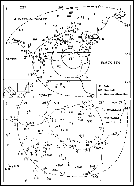
The epicentre is obviously situated in NE Bulgaria.
It corresponds, as a first approximation, to the central point of the innermost
isoseismal, the one of intensity 7, with coordinates 43°45' N, 26°55'
E. The determination error might be considered as equal to +/- 10 km, because
of the scarce information from the epicentral area. It is to be stressed
that the earlier epicentre shown at Ignatievo is at a distance of 100-120
km from the new one in a south-eastern direction. The same size of almost
hundred kilometres corresponds to the "epicentral line" proposed by Popescu
(1938) and by Atanasiu (1961).
The motion direction felt is also shown in Fig.
3. Following "the principles" of Mallet (1862), the location of the
earthquake epicentre in the area of Danube delta should be excluded.
Solving the problem of the source depth, one
more step would have been done by this study. It was noted that, in the previous
studies, the earthquake was considered to be a deep one (Tab. 1). Here, there
is an isoseismal map obtained by a unified intensity scale (MSK-64) through
a modern technique. Then, the source depth can be easily estimated.
The solution was found from the set of isoseismals
of intensity 7 to 5 MSK, applying the macroseismic formula of Blake (1941)
to two isoseismal pairs. As the most reliable isoseismal seemed that of degree
6, we kept its size constant, varying both the 7 and the 5 degree isoseismals.
In such a way the possible depth interval was found between 50 and 35 km.
The crust thickness in the epicentral region is no more than 35 km according
to Velcev and Petkov (1973). Therefore, the rupture most likely initiated
somewhere at the Mohorovicic boundary and its development continued
downwards.
Applying the generalised regional correlation
(Shebalin et al., 1974) to our set of data, the earthquake magnitude should
have been about 7.5. In NE Bulgaria especially, only a few, small earthquakes
are known. However, the intensity attenuation observed in that area for
earthquakes with the sources in the surroundings, is rather slight. The latter
might be a reason to suppose that the magnitude was not greater than 7.
Conclusions
It has been made clear that the contradictory
conclusions of previous studies on the 1892 earthquake are due to the following
reasons: fragmentary use of original descriptions; incomplete use of reports;
heritage of wrong suggestions and application of different intensity
scales.
Handling the entire quantity of reports, the
authors of this study made new assessments according to the MSK scale. As
a result of the analysis of the distribution of the intensity data it was
possible to assess the earthquake parameters as follows:
1892, October 14, 04 h. 54 min. GMT;
43°45' N, 26°55' E ( +/- 10 km);
h: 35-50 km; Io: 8 MSK; magnitude: up to 7
(uncertain).
The clarification of the "dilemma" (double
event) present in the catalogue of in Shebalin et al. (1974), a catalogue
of general acceptance, seems to be a contribution to knowledge of the seismicity
of the region and to a number of evolving tasks. In connection with the event
considered, there are still plenty of problems of regional importance to
be solved.
References
Atanasiu, I., 1961. Cutremurele de pamint
din Romania. Bucuresti.
Blake, A., 1941. On the estimation of focal
depth from macroseismic data. Bull. Seism. Soc. Am., 31: 225-231.
Draghiceanu, M., 1896. Les tremblements de
terre de Romanie et des pays environnants. Géologie appliquée,
Bucarest.
Florinesco, A., 1958. Catalogue des tremblements
de terre ressentis sur la territoire de la R.P.R. Académie de la R.P.R.,
Comité National de Géodesie et Géophysique pour l'A.G.I.,
Bucarest.
Grigorova, E., 1973. Catalogue of earthquakes
in Bulgaria before 1900. Sofia (manuscript).
Hepites, St., 1894. Le tremblement de terre
du 14 octobre 1892. Annales de l'Institute Méteorologique de Roumanie,
Bucarest, vol. 7, 20 pp.
Karnik, V., 1971. Seismicity of the European
area. II, Dordrecht, 218 pp.
Kirov, K., Grigorova, E., Ileff, N., 1960.
Contribution to the seismicity of Bulgaria. Bulgarian Academy of Sciences,
News of Geophysical Institute, 1: 137-183.
Mallet, R., 1862. The Great Neapolitan Earthquake
of 1857. The first principles of observational seismology, part 3. London.
In: Richter, Ch. F., 1963. Elementary Seismology. Moscow, pp.
36-41.
Nikonov, A.A. and Nikonova, C.I., 1989. The
destructive earthquake of October 14, 1892 in the Danube delta: recovering
the parameters from macroseismic evidence. Cursos y Seminarios, 3, pp.
125-133.
Popescu, I., 1938. Cutremurele de pamint
din Dobrogea. Analele Dobregei. Cernauti, pp. 22-24.
Rethly, A., 1952. A Karpatemedencek foldrengesei
(455-1918). Budapest.
Shebalin, N.V., Karnik, V. and Hadzievski,
D. (Editors), 1974. Catalogue of Earthquakes. Balkan Region, Part II: prior
to 1900. UNDP/UNESCO Survey of the Seismicity of the Balkan Region. Skopje,
600 pp.
Velcev, C. and Petkov, I., 1973. Structural
scheme of the Mohorovicic discontinuity in Bulgaria. Proc. Seminar Seismotect.
Map Balk. Reg., Appendix: Maps. UNDP/UNESCO Survey of the Seismicity of the
Balkan Region. Skopje.
Watzof, S., 1902. Tremblements de terre en
Bulgarie au XIXe siècle. Institut
Central Meteorologique de Bulgarie,
pp. 21-33, 77-80.
[Top]
[Vol.1]
[Vol.2]
[Deliverables and queries]
[Presentation]
[Homepage]