
Version 2.0
Editors
Mario Locati, Romano Camassi, Andrea Rovida,
Emanuela Ercolani, Filippo Bernardini, Viviana Castelli, Carlos Hector Caracciolo,
Andrea Tertulliani, Antonio Rossi, Raffaele Azzaro, Salvatore D’Amico, Andrea Antonucci
Data archive management by
Mario Locati, Andrea Rovida, Salvatore D'Amico, Andrea Antonucci
Contributors
Paola Albini, Maria Giovanna Bianchi, Cecilia Ciuccarelli, Alberto Comastri,
Dante Mariotti, Stefania Conte, Enrico Rocchetti
Website by
Mario Locati
DBMI15 is compiled in the framework of the agreement between the Department of
Civil Protection and Istituto Nazionale di Geofisica e Vulcanologia 2012-2021, Annex A.
November 2019
 Download the DBMI15 v2.0 DESCRIPTION as a PDF file |
 Download the DBMI15 v2.0 POSTER (70cm x 100cm) as a PDF file |
Terms of use
Citation
Licence
Disclaimer
DBMI15 is openly available via its dedicated website at http://emidius.mi.ingv.it/CPTI15-DBMI15,
and a “web service” via the Italian Archive of Historical Earthquake Data (ASMI) https://emidius.mi.ingv.it/ASMI/services/.
DBMI15 is a scientific product released by Istituto Nazionale di Geofisica (INGV) that required several years of work and makes available data released by various authors from different institutions.
DBMI15 can be used for scientific purposes and the source must always be cited.
It is forbidden to republish or duplicate the website under a different name or address
DBMI15 can be used, even partly, but it must be cited as follow:
Locati M., Camassi R., Rovida A., Ercolani E., Bernardini F., Castelli V., Caracciolo C.H., Tertulliani A., Rossi A., Azzaro R., D’Amico S., Antonucci A. (2019). Database Macrosismico Italiano (DBMI15), versione 2.0. Istituto Nazionale di Geofisica e Vulcanologia (INGV). https://doi.org/10.13127/DBMI/DBMI15.2
|
DBMI15 is released under the following licence Creative Commons Attribution-ShareAlike 4.0 International CC BY-SA 4.0 https://creativecommons.org/licenses/by-sa/4.0/ |

|
DBMI15 delivers data on the Italian seismicity and it is based on the available scientific knowledge; however, due to the complex natural phenomena dealt with, INGV cannot be made responsible for any incomplete or unreliable data provided in the catalogue, or for future events that may be inferred by users based on the data provided.
Istituto Nazionale di Geofisica e Vulcanologia and the DBMI15 authors are not responsible for the use that might be made of the data provided, nor are they responsible for any damage to third-parties caused by conclusions based on the data provided.
Version 2.0 of the Italian Macroseismic Database DBMI15 has been released in November 2019, and replaces the prevision version 1.5 (Locati et al. 2016) that was released in July 2016. This minor revision extend the time-coverage to the years between 2015 and 2017 and contains the correction of a few compilation errors; changes between v1.5 and v2.0 of DBMI15 are detailed in Section 6; changes occurred between DBMI11 (Locati et al., 2011) and DBMI15 are described in Section 5.
DBMI v2.0 makes available a set of macroseismic intensity data related to Italian earthquakes and covers the time-window 1000-2017. Intensity data derive from studies by authors from various Institutions, both in Italy and bordering countries (France, Austria, Slovenia, and Croatia).
Macroseismic Data Points (MDPs) are collected and organized in DBMI for several scopes. The main goal is to create a homogenous set of data for assessing earthquake parameters (epicentral location and magnitude) for compiling the Parametric Catalogue of Italian Earthquakes (CPTI). The data provided by DBMI are also used for compiling the seismic history of thousands of Italian localities (15332 in DBMI15), in other words the list of effects observed in a place through time as a consequence of earthquakes, expressed as macroseismic intensity degrees.
As they are closely linked, DBMI and CPTI have been published together, and using the same release version (e.g. DBMI04-CPTI04, DBMI11-CPTI11), but in two distinct websites.
From this release, DBMI and CPTI (Rovida et al., 2019) are made available using a unified website generated using an updated version of the software MIDOP (Locati and Cassera 2010).
DBMI15 contains 123756 macroseismic data points related to 3219 earthquakes. As shown in figures 1 and 2, there is a great increase in both the number of earthquakes with intensity data, and the total number of intensity data with respect to previous versions (DBMI04, Stucchi et al. 2007; DBMI11, Locati et al. 2011).
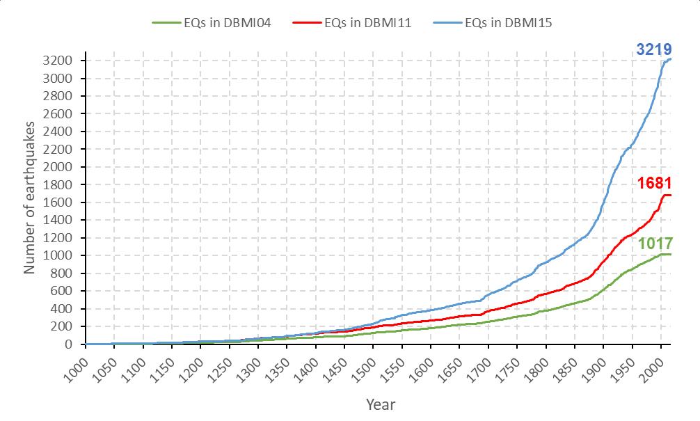
Fig. 1 – Comparison of the number of earthquakes per year in various DBMI releases:
DBMI15 in blue, DBMI11 in red, and DBMI04 in green.
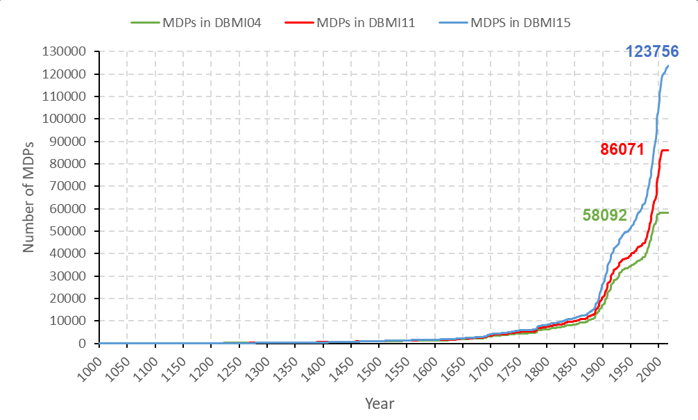
Fig. 2 – Comparison of the number of MDPs (Macroseismic Data Points) per year
in various DBMI releases DBMI15 in blue, DBMI11 in red, and DBMI04 in green..
The increase of data is mainly due to the inclusion of intensity data from studies dealing with a great number of earthquakes not yet considered during the compilation of DBMI11. Among these studies, there are Molin et al. (2008) dealing with low energy earthquakes, and Camassi et al. (2011) highlightingunknown and/or forgotten earthquakes, that provide data respectively on 851 and 227 earthquakes, even if not all these earthquakes were selected for entering DBMI15. Other important works that greatly contributed to the increase of data are those by Azzaro and Castelli (2015), and Camassi et al. (2012; 2015). A significant increase in MDPs is also due to intensity threshold, lowered from 5-6 to 5.
Tab. 1 - Main types of sources that contributed data to DBMI15.
| Tipo | Studies | Earthquakes | MDPs |
|---|---|---|---|
| Collection of earthquake files | 14 | 367 | 10971 |
| Data from macroseismic field surveys | 38 | 104 | 7637 |
| Technical reports | 19 | 230 | 4294 |
| Papers on journals or volumes | 70 | 257 | 12657 |
| Studies meant for updating DBMI | 4 | 1010 | 13345 |
| Macroseismic Bulletin | 36 | 392 | 36539 |
| Online databases | 4 | 859 | 38313 |
| Total | 185 | 3219 | 123756 |
Table 1 roughly synthetizes the type of data sources that contributed data to DBMI15. The largest number of MDPs comes from the Macroseismic Bulletin, 36539 MDPs related to 392 earthquakes, and from four online databases (38362 MDPs related to 860 earthquakes) among which the most relevant is CFTI4Med (28154 MDPs related to 560 earthquakes; Guidoboni et al. 2007). A significant number of earthquakes come from a series of reports specifically prepared for updating the DBMI content.
As for previous DBMI releases, in case of multiple studies related to the same earthquake, a selection has been carried out taking into account the quality of each study, and the number and spatial distribution of MDPs. All things being equal, the oldest work has been selected.
Among the works published by non-Italian authors, the most significant are the French databases SisFrance (BRGM-EDF-IRSN, 2014) with 114 earthquakes, for a total number of 5661 MDPs, and BD-MFC (BCSF 2015; 2016) with 7 earthquakes after the year 2000 reporting a total number of 2591 MDPs.
The number of available MDPs per earthquake is extremely variable; about a sixth (16.8%) of the earthquakes has only 1 MDP; the 8.6% of the earthquakes has 2 MDPs; a quarter (24.7%) has a set of MDPs between 3 and 10 MDPs; a third has between 10 and 50 MDPs; and a sixth (17.2%) has more than 50 MDPs (Fig. 3). No spatial cluster of earthquakes by number of MDPs is observed as they are equally distributed all along the Italian peninsula, while it is evident that earthquakes with a large number of MDPs greatly increase after 1850.
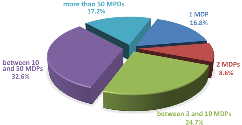
Fig. 3 - Percentage of earthquake per number of MDPs.
The 123756 MDPs are related to 20000 localities, of which 15332 are located in Italy (Fig. 4), and cover a total number of 7702 municipalities, out of the total 8047 (ISTAT 2015). By accessing the “query by locality” section of the website, users may obtain the seismic history of each locality, i.e. the list of earthquakes for which a macroseismic intensity is reported.
Figure 5 shows the significant number of MDPs with low intensities, and in particular between 3 and 5. The increase, with respect to the previous DBMI releases, is caused by the inclusion of many moderate energy earthquakes, especially after the 19th century (Fig. 6). The standard adopted for representing intensity data is the one proposed by AHEAD, European Archive of Historical Earthquake Data (click here for details on the symbol set
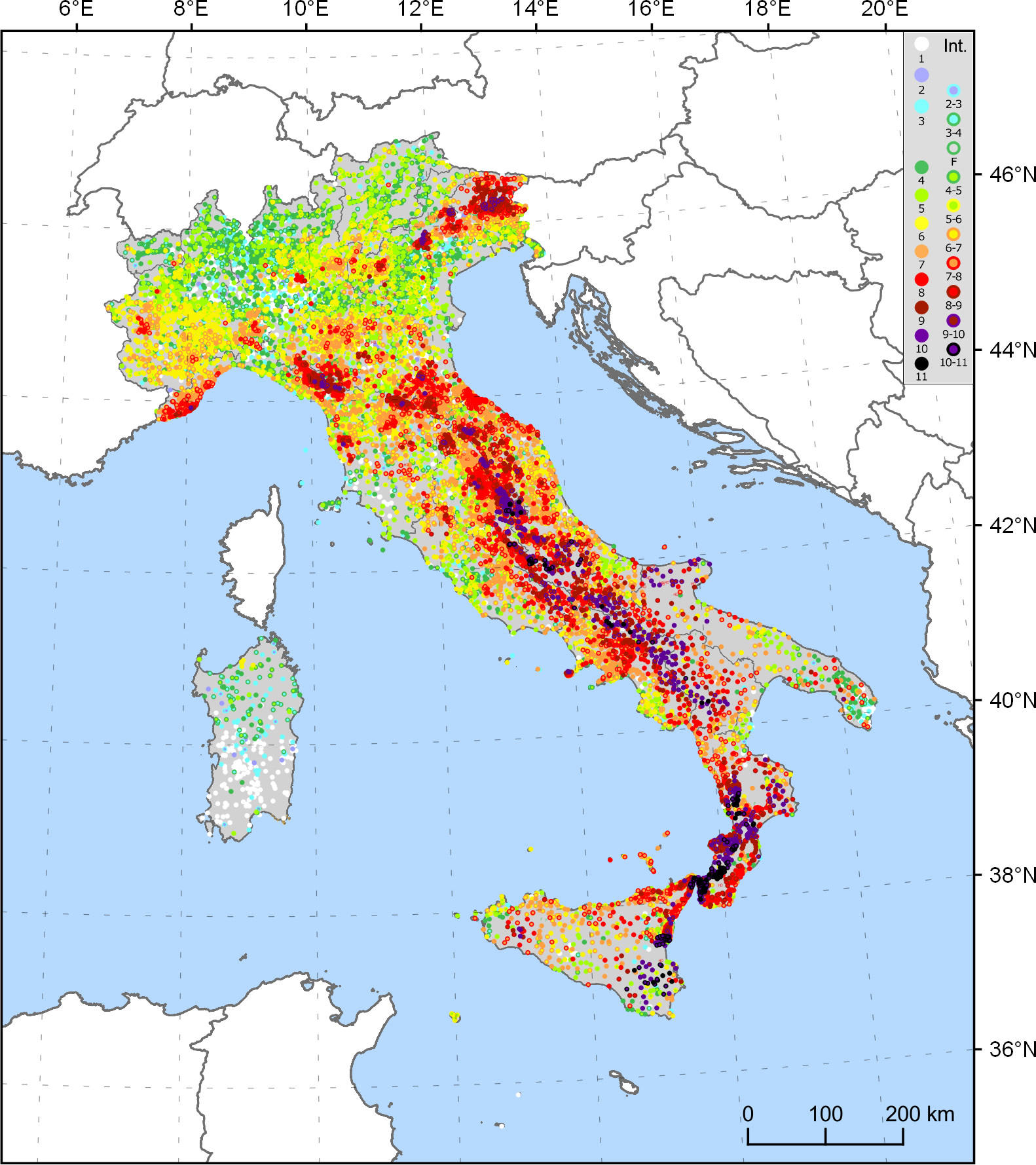
Fig. 4 – lot of the maximum observed intensities for the 15332 Italian localities.

Fig. 5 – Diagram of the number of MDPs per degree of intensity.
1000-1099, 9 EQ, 14 MDP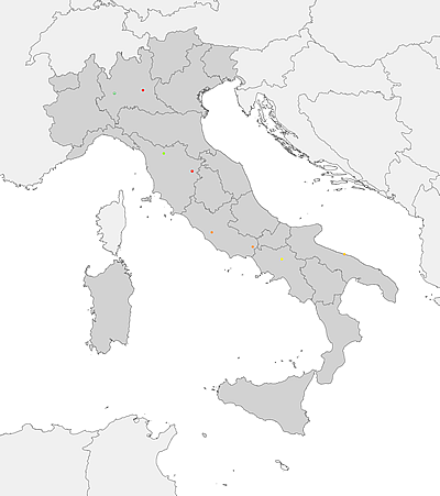 |
1100-1199, 20 EQ, 98 MDP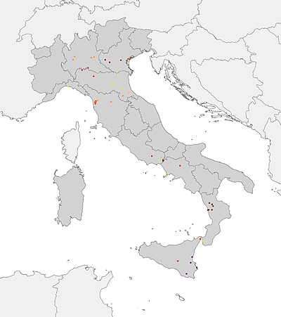 |
1200-1299, 33 EQ, 115 MDP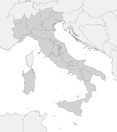 |
1300-1399, 62 EQ, 252 MDP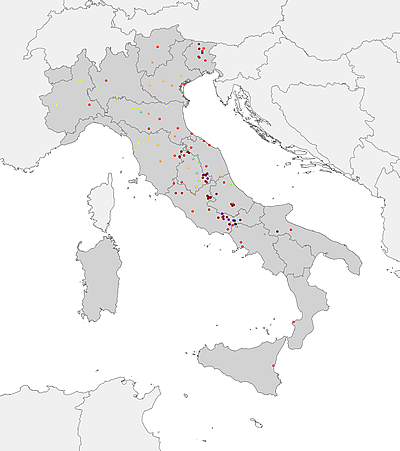 |
1400-1499, 108 EQ, 450 MDP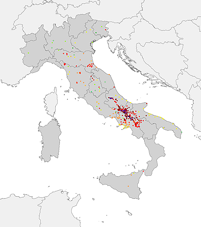 |
1500-1599, 151 EQ, 798 MDP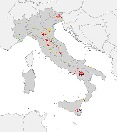 |
1600-1699, 172 EQ, 2194 MDP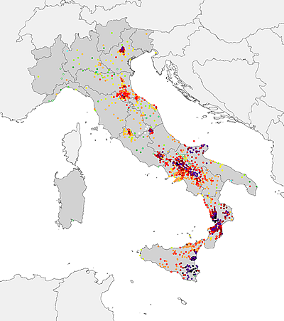 |
1700-1799, 366 EQ, 4302 MDP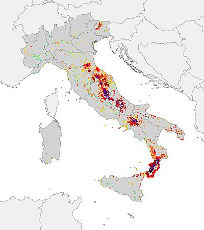 |
1800-1899, 656 EQ, 17685 MDP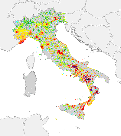 |
1900-1939, 605 EQ, 23396 MDP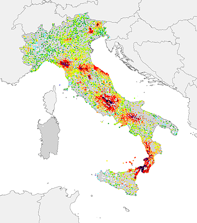 |
1940-1979, 424 EQ, 16552 MDP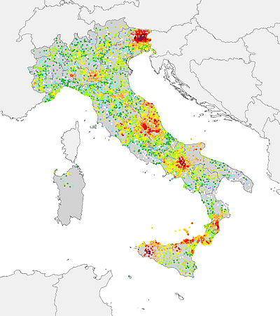 |
1980-2017, 613 EQ, 57902 MDP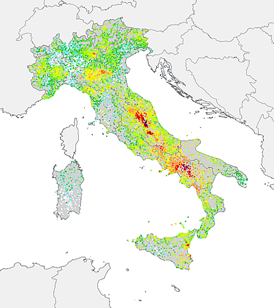 |
Fig. 6 - Plot of the maximum intensities per historical period.
The macroseismic intensity is by definition referred to a “locality”, meant as a populated area of a certain importance, independently from its present or past administrative role. The term “locality” equally refers to either region, province, or municipality capitals, and to variously sized hamlets, towns, or cities.
The Mercalli-Cancani-Sieberg scale (MCS, Sieberg, 1930) does not precisely define a locality, and the minimum or maximum number of buildings to be considered for a proper intensity assessment. A clear definition is instead given in the European Macroseismic Scale (EMS-98; Grünthal, 1998):
…intensity should not be assigned to a single building or street [or] a metropolis or a county….
…no smaller than a village … no larger than a moderately-sized European town…
…locations which are reasonably homogeneous, especially with regard to soil types, otherwise the range of shaking effects reported may be very large….
…It is also desirable to assign values to locations which are reasonably homogeneous, especially with regard to soil types, otherwise the range of shaking effects reported may be very large. However, this is not always practicable, depending on the precision in the data and how they were gathered. In the case where a town has areas in which the geotechnical conditions are very different (for instance, one half might be on an alluvial bank but the other on a plateau) then different intensity values should be assessed for the two parts of the town independently…
What it is clear to the authors of the macroseismic scales, including Mercalli in the versions of the scale prior to the MCS, is that intensity is a classification of the severity of the effects caused by the ground shaking on a “statistically” consistent sample of buildings; in particular, effects on single buildings, or on a small number of them, might be affected by local site conditions or vulnerability levels.
The official Italian administrative subdivisions are, in order of importance, 1) Regions, 2) Metropolitan Cities, 3) Provinces, 4) Municipalities. The Italian law does not provide any additional sub-division of a municipality.
The National Institute of Statistics (ISTAT 2011) defines a municipal sub-unit for statistical purposes only, but their definition greatly varies between each ten-year national census. A certain level of stability of these sub-units was introduced with the 1991 census, when a series of more or less precise definitions were given, in Italian “frazione geografica”, “centro abitato”, “nucleo abitato”, “case sparse”.
It is clear that such an unstable administrative sub-unit definition cannot be adopted to describe observations spanning over a millennium, therefore the generic term “locality” is adopted. Only for a convenient use of the “query by locality” section, users can search for a specific locality by the administrative subdivision where it is today located, as it is officially reported by the National Institute of Statistics in the year 2015.
DBMI15 is a compilation of a very large number of studies published by various authors during a time-window of many decades. Each study has its own solution for presenting results, and provide intensity data according to different rules and tables, either with or without geographic coordinates, sometimes simply showing a map of the intensity values. An additional level of complexity in the data collection and archiving is caused by the fact that, apart from recent ones, the majority of the studies are available only as hardcopies.
A series of operations were performed in order to obtain a homogenous set of intensity data, without altering the original information.
The standardization performed for DBMI15 is consistent with those adopted in the compilation of the European Archive of Historical Earthquake Data (AHEAD; Locati et al. 2014).
Most of the considered seismological sources provide the geographical coordinates of the cited localities. However, each source adopts a different approach for presenting these coordinates: some adopt the sexagesimal system, some the decimal system. Some sources do not provide coordinates, but simply a list of place names, either past or present, sometimes accompanied by the name of the corresponding municipality. Sometimes sources provide only a map and not the corresponding table. The position of a locality associated to a macroseismic observation is of fundamental importance, both for the reconstruction of the seismic history of a site and for the calculation of the earthquake parameters, so DBMI adopts, since its earlier versions, an internal gazetteer that covers the whole national territory, and that is continuously updated. In the gazetteer each record represents a locality, with place name, coordinates and moreover, an identifier, and other useful information. The gazetteer grants the unequivocal association of a place name with a pair of geographical coordinates, and the association of a locality reported in a data source to the corresponding locality in the Gazetteer must be performed carefully, verifying their actual correspondence, therefore is usually performed manually. When the data source provides precise information on the position and the place name, the association is straightforward. Vice versa, when the provided information is incomplete, inaccurate, or imprecise, the association can be tricky, especially for different localities with similar names in the same area, leading to a certain level of ambiguity. If the study provides neither coordinates nor a map, the association with the gazetteer is uncertain. In extreme cases, it is impossible to identify the position of a locality, because there is no trace of it in any of the checked geographical references (e.g. historical maps by the Military Geographic Institute, Google Maps, Bing Maps, Open Street Map, Tuttocittà, ViaMichelin). The geographical coordinates provided by the Gazetteer are expressed in decimal degrees, using the revision WGS84 of the World Geodetic System.
From a macroseismic point-of-view, a locality can be generally defined as a populated area. Depending on the available information, it may be difficult to associate a precise locality with the reported observations. Some authors propose to retain the information about effects related either to areas other than proper localities such as a valley, historical regions, extensive areas or to isolated houses, lighthouses, towers, castles. DBMI15 provides a code to identify such special cases, according to different typologies (Tab. 2).
Tab. 2- List of the codes used in DBMI15 for special cases of localities, and the related number of MDPs.
| SC Special Case |
Meaning | Description | MDPs | Localities |
|---|---|---|---|---|
| TE | Territory | A large area (e.g. a valley) for which the information available does not allow to identify a proper locality. | 271 | 220 |
| IB | Isolated Building | An isolated building (e.g.lighthouse), not compatible with the statistical meaning of intensity. | 241 | 144 |
| SS | Small Settlement | A settlement too small to supply a significant building sample for intensity assessment (e.g. monastery complex) | 625 | 287 |
| MS | Multiple Settlement | Settlement whose traditional place name refers to a set of small settlements in a limited area, including small islands. | 4274 | 572 |
| DL | Deserted Locality | Abandoned locality, eventually rebuilt elsewhere with the same or another name. Today it might appear as a toponym on old maps only, or as ruins. | 220 | 71 |
| AL | Absorbed Locality | A locality absorbed into a larger one. | 163 | 41 |
| CQ | City Quarter | Information related to part of a city, for which there is already an intensity assessment. | 45 | 27 |
| UL | Unidentified Locality | A place that the study and the DBMI compilers are not able to locate the geographical position. | 109 | 109 |
The place names reported in the data sources follow different standards, as they might report locality names as mentioned by the historical sources, or in the language in use at the time of the earthquake, or using the corresponding modern, official names.
DBMI15 conventionally presents the modern official name, preserving the name reported by the data source for tracing back the originals in case of need.
As already mentioned, DBMI uses an internal reference gazetteer, that allowed to associate a unique identifier to each mentioned locality. Place identifiers are the key for generating the seismic history of a locality, and are obtained by retrieving the list of earthquakes for which there is a macroseismic observation related to such locality.
Starting from DBMI15 the identifier of the locality is made public to allow the users of the website to point directly to a locality using the following path scheme:
“http://emidius.mi.ingv.it/CPTI15-DBMI15/place/” + identifier of the locality
Example: seismic history of Rome, identifier “IT_54180”
http://emidius.mi.ingv.it/CPTI15-DBMI15/place/IT_54180
The considered studies use different standards for reporting macroseismic intensities. As an example, intensities are often expressed in either roman numerals (e.g. VI-VII, VIII, IX) or Arabic numbers (e.g. 6-7, 8, 9), other studies give uncertain degrees as decimals (e.g. 6.5, 8, 9).
DBMI15 adopts the standard proposed by AHEAD for intensities, that foresees the use of Arabic numbers (e.g. 8, 9), and a dash for expressing uncertain degrees (e.g. 6-7).
In addition, the AHEAD standard rigorously applies the guidelines of macroseismic scales, according to which intensities are not assessed for single buildings, or very large areas. In such cases, the value reported by the data source is modified. If the available information it is not considered sufficient for assessing an intensity, it is possible to adopt non-conventional descriptive codes such as “D” for damage, or “F” for felt. Table 3 reports the complete list of these descriptive codes, the corresponding numerical value for sorting tables, and the number of MDPs affected.
Tab. 3 – List of non-conventional descriptive codes, their meaning, and the corresponding number of MDPs.
| Code | Ass. value | Description | MDPs |
|---|---|---|---|
| RS | - | Instrumental registration. If present, these observations have been rejected. | - |
| NR | - | Not Reported. If present, these observations have been rejected. | - |
| W | - | Tsunami, sea Waves. If present, these observations have been rejected. | - |
| E | - | Environmental effects. If present, these observations have been rejected. | - |
| G | 0.2 | Generic damage information | 5 |
| NF | 1 | Not Felt | 24028 |
| NC | 1.8 | Not Classified | 131 |
| SF | 2.9 | Slightly Felt | 49 |
| F | 3.9 | Felt | 5400 |
| HF | 5.1 | Highly Felt | 112 |
| SD | 5.6 | Slight Damage | 31 |
| D | 6.4 | Damage | 707 |
| HD | 8.6 | Heavy Damage | 189 |
In case the data source associated an intensity degree to a building or a vast area, DBMI recompiles the original intensity as it is reported in Table 4.
Tab. 4 - Intensity compilation rules, in relation to special cases of localities.
Between brackets is represented a corresponding decimal value, used internally for sorting tables.
| Special Cases | Original intensity | ||||||||||||||||||||
|---|---|---|---|---|---|---|---|---|---|---|---|---|---|---|---|---|---|---|---|---|---|
| 1 | 1-2 | 2 | 2-3 | 3 | 3-4 | 4 | 4-5 | 5 | 5-6 | 6 | 6-7 | 7 | 7-8 | 8 | 8-9 | 9 | 9-10 | 10 | 10-11 | MDPs | |
| no SC | NF (1) |
1-2 (1.5) |
2 (2) |
2-3 (2.5) |
3 (3) |
3-4 (3.5) |
4 (4) |
4-5 (4.5) |
5 (5) |
5-6 (5.5) |
6 (6) |
6-7 (6.5) |
7 (7) |
7-8 (7.5) |
8 (8) |
8-9 (8.5) |
9 (9) |
9-10 (9.5) |
10 (10) |
10-11 (10.5) |
111975 |
| AL | 148 | ||||||||||||||||||||
| CQ | 44 | ||||||||||||||||||||
| DL | 206 | ||||||||||||||||||||
| SS | 449 | ||||||||||||||||||||
| MS | 4143 | ||||||||||||||||||||
| UL | 76 | ||||||||||||||||||||
| IB | NF (1) |
SF (2.9) |
F (3.9) |
HF (5.1) |
SD (5.6) |
D (6.4) |
HD (8.6) |
166 | |||||||||||||
| TE | 53 | ||||||||||||||||||||
The study CFTI4Med, that represents the 17% of the earthquakes and the 23% of the MDPs of DBMI15, adopts some non-conventional descriptive codes of the effects (Tab. 5). Such codes are explained in the old release CFTI2 (Boschi et al. 1997). As the goal of DBMI is to provide a homogenous set of intensities, the CFTI non-conventional codes have been recompiled according to Table 6.
Tab. 5 – List of all non-conventional descriptive codes used in CFTI.
| Code | Ass. value | Description |
|---|---|---|
| EE | -2 | Environmental effects only. |
| NC | -1 | Not classified, si rimanda ai commenti analitici |
| NF | 0 | Earthquake not felt |
| N | 0.1 | Riscontro negativo nelle fonti coeve |
| G | 0.2 | Generic damage indication in a locality |
| F | 4.6 | Earthquake was felt |
| S | 5.1 | Strongly felt, but not enough information to establish whether there is a damage or not |
| D | 6.1 | falling eaves, cracking, or general indication of damage to the building which has not prevented it from being used |
| E | 6.6 | Generic damage indication to a building |
| C | 8.1 | Partial collapse of the roof |
| B | 8.2 | collapse limited to the top of the building |
| A | 9.1 | Colapse and/or extensive damage to load-bearing walls |
Tab. 6 - Recompilation scheme of CFTI descriptive codes and the corresponding number of MDPs.
| Original Intensity | EE (-2) |
NC (-1) |
NF (0) |
N (0.1) |
G (0.2) |
F (4.6) |
S (5.1) |
MDPs |
|---|---|---|---|---|---|---|---|---|
| no SC | E (0.9) |
NC (1.8) |
1 (1) |
NR (0.7) |
G (0.2) |
F (3.9) |
HF (5.1) |
3260 |
| AL | 10 | |||||||
| CQ | - | |||||||
| DL | 4 | |||||||
| SS | 62 | |||||||
| MS | 96 | |||||||
| UL | 13 | |||||||
| IB | 15 | |||||||
| TE | 115 |
Tab. 6 (continuation).
| Original Intensity | D (6.1) |
E (6.6) |
C (8.1) |
B (8.2) |
A (9.1) |
MDPs |
|---|---|---|---|---|---|---|
| no SC | D (6.4) |
HD (8.6) |
372 | |||
| AL | 1 | |||||
| CQ | - | |||||
| DL | 5 | |||||
| SS | 94 | |||||
| MS | 18 | |||||
| UL | 8 | |||||
| IB | 40 | |||||
| TE | 70 | |||||
Sometimes the available information is not detailed enough to assess an intensity degree in a straightforward way, and such an uncertainty is expressed with a range (e.g. 6-7, 7-8).
It may happen that the uncertainty is retained so high to be express as a wide range of degrees, and intensities such as 5-7 or 3-5 might appear in the original data. This information cannot be used directly in the calculations that use macroseismic intensities, nor should an average value be used.
The solution adopted in DBMI15 is to properly assign one of the available non-conventional descriptive values (e.g. “HD”, “D”, or “F”), selecting the best matching code using some indication provided by the EMS-98 scale (Tab. 7). Percentages are calculated taking into account the number of classes that fall in the uncertain intensity classes (Fig. 7). As an example, intensity 5-7 contains 5 degrees (5, 5-6, 6, 6-7, 7); as “HF” correspond to class 5, so 1 class divided by 5 is 0.20; “SD” correspond to class 5-6, so again 1 divided by 5 is 0.20; class “D” correspond to 3 classes 6, 6-7 and 7, so 3 classes divided by 5 is 0.60.
Tab. 7 - List of the greatly uncertain intensities found in the sources used by DBMI15 and
their relation with the corresponding percentages of the non-conventional descriptive codes.
| Greatly uncertain intensity |
non-conventional descriptive codes | |||||
|---|---|---|---|---|---|---|
| SF | F | HF | SD | D | HD | |
| ≥ 7 | 0 | 0 | 0 | 0 | 0.25 | 0.75 |
| 6-8 | 0 | 0 | 0 | 0 | 0.80 | 0.20 |
| 5-7 | 0 | 0 | 0.20 | 0.20 | 0.60 | 0 |
| 4-6 | 0 | 0.20 | 0.40 | 0.20 | 0.20 | 0 |
| 3-5 | 0.20 | 0.40 | 0.40 | 0 | 0 | 0 |
| 2-5 | 0.43 | 0.29 | 0.29 | 0 | 0 | 0 |
| 2-4 | 0.60 | 0.40 | 0 | 0 | 0 | 0 |
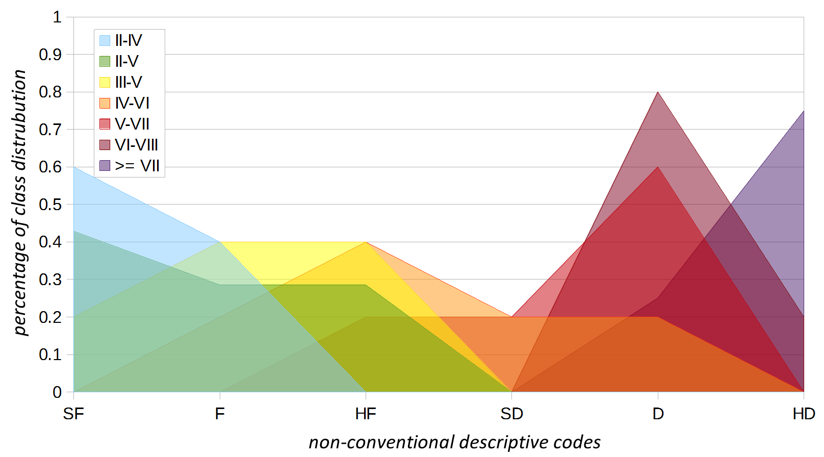
Fig. 7 – Visual representation of the relation between greatly uncertain intensities,
and non-conventional descriptive codes.
From table and figure 7 it can be observed that:
DBMI therefore adopts the numerical value corresponding to the non-conventional descriptive code following what is reported in table 8. Purely for comparison purpose, it reported the average value between the two extremes, and the non-conventional descriptive code where the value falls.
Tab. 8 – Recompilation scheme adopted by DBMI for greatly uncertain intensities.
| Greatly uncertain intensity |
Best matching representative code |
Numerical value | Media degli estremi | Equivalent descriptive code |
|---|---|---|---|---|
| ≥ 7 | HD | 8.6 | 9.0 | HD |
| 6-8 | D | 6.4 | 7.0 | D |
| 5-7 | D | 6.4 | 6.0 | D |
| 4-6 | SD | 5.6 | 5.0 | HF |
| 3-5 | HF | 5.1 | 4.0 | F |
| 2-5 | F | 3.9 | 3.5 | F |
| 2-4 | SF | 2.9 | 3.0 | SF |
For 1494 out of the total of 3219 earthquakes (46.5%) DBMI15 adopts the same data source as it was selected for DBMI11. For 172 earthquakes (5.4%) the selected study has been changed. 15 earthquakes have been removed, of which 4 removed because the data source (Bollettino Macrosismico ING, Gasparini et al. 2002) has proved to be largely unreliable, whereas 11 of them proved to be fake by recent studies.
DBMI15 makes available new intensity datasets for 1546 earthquakes (48.1%), of which 895 earthquakes already reported by CPTI11 but without intensity data, and 651 completely new earthquakes with respect to CPTI11. Table 9 summarize the comparison between DBMI11 and DBMI15, whereas table 10 shows the data sources that contributed most of the new earthquakes.
Tab. 9 – Comparison summary between set of MDPs in DBMI11 and in DBMI15.
| Description | Earthquakes |
|---|---|
| Common MDP sets between DBMI11 e DBMI15 | 1494 |
| MDP sets that changed the refence study | 172 |
| MDP sets removed because related to fkae earthquakes | 11 |
| MDP sets removed because the reference study is not reliable | 4 |
| New MDP sets associated to earthquakes already in CPTI11 | 895 |
| New MDP sets associated to earthquakes not in CPTI11 | 658 |
Tab. 10 – Main data sources that contributed new earthquakes to DBMI15.
| Reference study | new EQs | % new EQs | % of EQs in DBMI15 |
|---|---|---|---|
| Molin et al., 2008 | 702 | 45.4 | 21.9 |
| Bollettino Macrosismico ING/INGV | 236 | 15.3 | 7.3 |
| Camassi et al., 2011b | 191 | 12.4 | 5.9 |
| SisFrance, 2014 | 111 | 7.2 | 3.5 |
| CFTI4med | 106 | 6.9 | 3.3 |
| Camassi et al., 2012 | 30 | 1.9 | 0.9 |
| Guidoboni and Ciuccarelli, 2011 | 27 | 1.7 | 0.8 |
| Azzaro et al., 2014 | 16 | 1.0 | 0.5 |
| Azzaro et al., 2000 | 12 | 0.8 | 0.4 |
| Camassi and Molin, 1994 | 11 | 0.7 | 0.3 |
| Other studies | 104 | 6.7 | 3.2 |
| 1546 | 100% | 48.1% |
As a final remark, data from the ING (1980-1999) and then INGV (2000-2005) Macroseismic Bulletin, that were digitally acquired during the compilation of DBMI11, have been thoroughly checked against the original hard copies of all the 35 volumes. Such an extensive check causes some minor differences between data from the Macroseismic Bulletin in DBMI11 and DBMI15.

Fig. 8 – Covers of all the 35 issues of the Macroseismic Bulletin, published from the year 1980 up to 2005.
The version 2.0 of DBMI15 extends its time-coverage from December 2014 up to December 2017, allowing the inclusion of 7 new earthquakes, for which QUEST (Quick Earthquake Survey Team of INGV) provides macroseismic obervations, for a total of 1058 new MDPs. Among the new data, there are also those derived from the macroseismic surveys performed for the 2016-2017 earthquake sequence in Central Italy.
Tab. 11 – List of the 7 new earthquakes included in DBMI15 v2.0 in the time-window 2015-2017
| EqID | Year Mo Da Ho Mi Se | Epicentral area | Study | MDP | Imax |
|---|---|---|---|---|---|
| 20151208_0928_000 | 2015 12 08 09 28 29.85 | Etna - Versante nord-orientale | Azzaro et al., 2015 | 19 | 5 |
| 20160208_1535_000 | 2016 02 08 15 35 43.39 | Monti Iblei | Azzaro et al., 2016 | 58 | 5 |
| 20160824_0136_000 | 2016 08 24 01 36 32.00 | Monti della Laga | Rossi et al., 2019 | 221 | 10 |
| 20161026_1918_001 | 2016 10 26 19 18 07.42 | Valnerina | Rossi et al., 2019 | 77 | HD |
| 20161030_0640_000 | 2016 10 30 06 40 17.32 | Valnerina | Rossi et al., 2019 | 379 | 11 |
| 20170118_1014_000 | 2017 01 18 10 14 09.90 | Aquilano | Rossi et al., 2019 | 280 | 8 |
| 20170821_2057_000 | 2017 08 21 18 57 51.78 | Isola d'Ischia | Azzaro et al., 2017 | 24 | 8 |
The present release of DBMI15 v2.0 also fixed a series of errors discovered in DBMI15 v1.5, published in July 2016. Below a detailed list of the changes between v1.5 and v2.0:
The collection, examination, selection, and standardization of a database of 123756 macroseismic observations related to 3219 earthquakes extracted from nearly 200 data sources is a great achievement, that required many years of work and involved many people. DBMI15 represent the result of a continuos activity started around 1995 in the framework of the working group called “Seismicity” of the GNDT (Gruppo Nazionale per la Difesa dai Terremoti, http://emidius.mi.ingv.it/GNDT/), that culminated in 1997 with the publication of the database DOM4.1 (Monachesi e Stucchi, 1997), that later on evolved in DBMI04 and DBMI11.
It is not possible to thank each person that contributed to accomplish the present status, making available their data, either providing professional advices, or simply by actively supporting the various performed tasks in such a long period. Among all, we owe a debt of gratitude to Giancarlo Monachesi who was the first to start working on intensity data using -by today’s standard- primitive technological equipment, and we would like to thank Massimiliano Stucchi that has guided this journey for a long time.
Among the many others who contributed with their passionate work, we would like to thank Fabio Meloni, a friend that meanwhile left us. It has been long since he published his works, but still today, they can be considered as a reference.
Azzaro R., D’Amico S., Scarfì L., Tuvè T., 2015. Rapporto macrosismico sul terremoto etneo del 8/12/2015 ore 10:28 locali. Istituto Nazionale di Geofisica e Vulcanologia (INGV), Osservatorio Etneo, 3 pp. https://doi.org/10.13127/QUEST/20151208
Azzaro R., D'Amico S., Mostaccio A., Scarfì L., Tuvè T., 2016. Rilievo macrosismico del terremoto ibleo dell'8 febbraio 2016 - ore 16:35 locali - Relazione. Istituto Nazionale di Geofisica e Vulcanologia (INGV), Catania, 6 pp. https://doi.org/10.13127/QUEST/20160208
Azzaro R., Tertulliani A., Del Mese S., Graziani L., Maramai A., Martini G., Paolini S., Screpanti A., Verrubbi V., Arcoraci L., 2017. QUEST- Rilievo macrosismico per il terremoto dell'isola di Ischia del 21 agosto 2017. Rapporto finale. Rapporto tecnico QUEST, Istituto Nazionale di Geofisica e Vulcanologia (INGV), ENEA, 6pp. https://doi.org/10.5281/ZENODO.886047
Azzaro R., Castelli V., 2015. Materiali per un catalogo di terremoti etnei dal 1600 al 1831. Quaderni di Geofisica, 123, INGV, Roma, 284 pp.
Boschi E., Guidoboni E., Ferrari G., Valensise G., Gasperini P. (eds.), 1997. Catalogo dei forti terremoti in Italia dal 461 a.C. al 1990, vol. 2. ING-SGA, Bologna, 644 pp.
BCSF, 2015. BD-MFC, Base de Données Macrosismiques Françaises Contemporaines. Le Bureau Central Sismologique Français, Ecole et Observatoire des Sciences de la Terre.
BCSF, 2016. BD-MFC, Base de Données Macrosismiques Françaises Contemporaines. Le Bureau Central Sismologique Français, Ecole et Observatoire des Sciences de la Terre.
BRGM-EDF-IRSN/SisFrance, 2014. Histoire et caractéristiques des séismes ressentis en France. http://www.sisfrance.net
Camassi R., Caracciolo C.H., Castelli V., Ercolani E., Bernardini F., Albini P., Rovida A., 2012. Contributo INGV al WP2 del progetto HAREIA - Historical and Recent Earthquakes in Italy and Austria: Studio della sismicità storica del Friuli Venezia-Giulia, Veneto e Alto Adige. Rapporto finale, Bologna, 23 pp. + 5 Allegati Camassi et al. (2015).
Camassi R., Castelli V., Molin D., Bernardini F., Caracciolo C. H., Ercolani E. and Postpischl L., 2011. Materiali per un catalogo dei terremoti italiani: eventi sconosciuti, rivalutati o riscoperti. Quaderni di Geofisica, 96, INGV, Roma, 53pp.
Camassi R., Castelli V., Caracciolo C.H., Ercolani E., Bernardini F., 2015. Revisione speditiva di alcuni terremoti di area nord occidentale. Rapporto interno, Istituto Nazionale di Geofisica e Vulcanologia (INGV), 27 pp.
Gasparini C., Conte S., Rocchetti E., Saraceni A. M., Vannucci C., 2002. Bollettino macrosismico - Terzo quadrimestre 1998. Istituto Nazionale di Geofisica (INGV), Roma, 58 pp.
Grünthal G. (ed) (1998) European Macroseismic Scale 1998 (EMS-98). Cahiers du Centre Européen de Géodynamique et de Séismologie 15, Centre Européen de Géodynamique et de Séismologie, Luxembourg. ISBN:2-87977-008-4
Guidoboni E., Ferrari G., Mariotti D., Comastri A., Tarabusi G., Valensise G., 2007. CFTI4Med, Catalogue of Strong Earthquakes in Italy (461 B.C.-1997) and Mediterranean Area (760 B.C.-1500). INGV-SGA.
ISTAT (2015). Codici statistici delle unità amministrative territoriali. http://www.istat.it/it/archivio/6789
ISTAT (2011). Popolazione: Territorio e processi di inurbamento. Serie Storiche ISTAT. http://seriestoriche.istat.it/
Locati M., Camassi R., Stucchi M. (a cura di), 2011. Database Macrosismico Italiano (DBMI11). Istituto Nazionale di Geofisica e Vulcanologia (INGV), Milano, Bologna. http://doi.org/10.6092/INGV.IT-DBMI11
Locati M., Camassi R., Rovida A., Ercolani E., Bernardini F., Castelli V., Caracciolo C.H., Tertulliani A., Rossi A., Azzaro R., D’Amico S., Conte S., Rocchetti E., 2016. Database Macrosismico Italiano (DBMI15), versione 1.5. Istituto Nazionale di Geofisica e Vulcanologia (INGV). https://doi.org/10.6092/INGV.IT-DBMI15
Locati M., Cassera A., 2010. MIDOP: Macroseismic Intensity Data Online Publisher, Rapporti Tecnici, Istituto Nazionale di Geofisica e Vulcanologia (INGV), Vol. 123, 92 pp. https://www.emidius.eu/MIDOP/
Locati M., Rovida A., Albini P., and Stucchi M., 2014. The AHEAD Portal: A Gateway to European Historical Earthquake Data. Seismological Resource Letters, 85, 3, pp.727-734. http://doi.org/10.1785/0220130113
Molin D., Bernardini F., Camassi R., Caracciolo C.H., Castelli V., Ercolani E., Postpischl L., 2008. Materiali per un catalogo dei terremoti italiani: revisione della sismicità minore del territorio nazionale, Quaderni di Geofisica, 57, INGV, Roma, 75pp.
Monachesi G., Stucchi M., 1997. DOM4.1, un database di osservazioni macrosismiche di terremoti di area italiana al di sopra della soglia del danno. GNDT, Internal report, Milano-Macerata.
Rossi A., Tertulliani A., Azzaro R., Graziani L., Rovida A., Maramai A., Pessina V., Hailemikael S., Buffarini G., Bernardini F., Camassi R., Del Mese S., Ercolani E., Fodarella A., Locati M., Martini G., Paciello A., Paolini S., Arcoraci L., Castellano C., Verrubbi V., Stucchi M., 2019. The 2016-2017 earthquake sequence in central Italy: macroseismic survey and damage scenario through the EMS-98 intensity assessment. Bulletin of Earthquake Engineering, 17, 2407-2431. https://doi.org/10.1007/s10518-019-00556-w
Rovida A., Locati M., Camassi R., Lolli B., Gasperini P., 2019. Catalogo Parametrico dei Terremoti Italiani (CPTI15), versione 2.0. Istituto Nazionale di Geofisica e Vulcanologia (INGV). http://doi.org/10.13127/CPTI/CPTI15.2
Sieberg A (1930) Geologie der Erdbeben. Handbuch der Geophysik 2(4):552-555.
Stucchi M., Camassi R., Rovida A., Locati M., Ercolani E., Meletti C., Migliavacca P., Bernardini F., Azzaro R. (eds.), 2007. DBMI04, il database delle osservazioni macrosismiche dei terremoti italiani utilizzate per la compilazione del catalogo parametrico CPTI04. Quaderni di Geofisica, 49, INGV, Roma, 38 pp.
https://doi.org/10.6092/INGV.IT-DBMI04
| Code | Full citation | EQs | MDPs |
|---|---|---|---|
| ALBRV010 | Albini P., Rovida A., 2010. The 12 May 1802 earthquake (N Italy) in its historical and seismological context. J. Seismol., 14, 629-651. https://doi.org/10.1007/s10950-010-9187-6 | 1 | 94 |
| ALBAL994a | Albini P., Bellettati D., Camassi R., Moroni A., Stucchi M., Zerga A. (eds.), 1994a. Revisione dei terremoti di interesse per il territorio della Provincia di Trento. Rapporto tecnico per la Provincia Autonoma di Trento, IRRS-CNR, Milano, 210 pp. | 7 | 251 |
| ALBAL994c | Albini P., Cecic I., Morelli G., Sovic I., Zivcic M., 1994c. A preliminary investigation of the January 4th, 1802 earthquake. In: P. Albini and A. Moroni (eds.), Materials of the CEC project "Review of Historical Seismicity in Europe", CNR, Milano, vol. 2, 205-214. | 1 | 8 |
| ALBAL003 | Albini P., Migliavacca P., Moroni A., 2003. Studio di alcuni terremoti di intensità epicentrale moderata in Italia settentrionale. Rapporto tecnico, Istituto Nazionale di Geofisica e Vulcanologia (INGV), Milano, 58 pp. + appendices. | 23 | 175 |
| ALBI001 | Albini P., 2001. Studio preliminare di alcuni terremoti di energia medio-bassa nell'area di Vittorio Veneto (sec. XIX). Rapporto tecnico per il Progetto GNDT "Scenari di danno in area veneto-friulana", Istituto Nazionale di Geofisica e Vulcanologia (INGV), Milano, 6 pp. | 5 | 73 |
| ALEX990 | Alexandre P., 1990. Les séismes en Europe occidentale de 394 à 1259. Nouveau catalogue critique. Observatoire Royal de Belgique, Série Geophysique, Bruxelles, 267 pp. | 1 | 2 |
| AMGNDT995 | Archivio Macrosismico GNDT, 1995. Studi preliminari di terremoti attraverso i repertori sismologici. Archivio macrosismico del GNDT, Milano. | 241 | 7561 |
| ARCAL010 | Arcoraci L., Berardi M., Castellano C., Leschiutta I., Maramai A., Rossi A., Tertulliani A. and Vecchi M., 2010. Rilievo macrosismico del terremoto del 15 dicembre 2009 nella Valle del Tevere e considerazioni sull'applicazione della scala EMS98. Quaderni di Geofisica, 82, Istituto Nazionale di Geofisica e Vulcanologia (INGV), Roma, 21 pp. https://doi.org/10.13127/QUEST/20091215 | 1 | 26 |
| ARCAL012a | Arcoraci L., Berardi M., Brizuela B., Castellano C., Del Mese S., Graziani L., Maramai A., Rossi A., Sbarra M., Tertulliani A., Vecchi M., Vecchi S., Bernardini F., Ercolani E., 2012. Rilievo macrosismico degli effetti del terremoto del 25 gennaio 2012 (Pianura Padana). Rapporto tecnico QUEST, Istituto Nazionale di Geofisica e Vulcanologia (INGV), Roma, 9 pp. https://doi.org/10.13127/QUEST/20120125 | 1 | 25 |
| ARCAL013 | Arcoraci L., Bernardini F., Brizuela B., Ercolani E., Graziani L., Leschiutta I., Maramai A., Tertulliani A., Vecchi M., 2013. Rapporto macrosismico sul terremoto del 21 giugno 2013 (ML 5.2) in Lunigiana e Garfagnana (province di Massa-Carrara e di Lucca) (aggiornato al 30 giugno 2013). Rapporto tecnico QUEST, Istituto Nazionale di Geofisica e Vulcanologia (INGV), Roma, 5 pp. https://doi.org/10.13127/QUEST/20130621 | 1 | 27 |
| AZZBA995 | Azzaro R., Barbano M.S., 1995. The Pollina (northern Sicily-Italy) earthquake of 26 June 1993: an application of the new European Macroseismic Scale 1992. Nat. Haz., 12, 289-301. https://doi.org/10.1007/BF00596223 | 1 | 47 |
| AZZBA000 | Azzaro R., Barbano M.S., 2000. Analysis of the seismicity of Southeastern Sicily: a proposed tectonic interpretation. Annali di Geofisica, 43, 1, 171-188. https://doi.org/10.4401/ag-3628 | 3 | 87 |
| AZZCA015 | Azzaro R., Castelli V., 2015. Materiali per un catalogo di terremoti etnei dal 1600 al 1831. Quaderni di Geofisica, 123, Istituto Nazionale di Geofisica e Vulcanologia (INGV), Roma, 284 pp. | 11 | 23 |
| AZZAL000 | Azzaro R., Barbano M.S., Antichi B., Rigano R., 2000. Macroseismic catalogue of Mt. Etna earthquakes from 1832 to 1998. Acta Vulcanologica, 12, 1-2, 3-36 + CD | 183 | 3579 |
| AZZAL002 | Azzaro R., D'Amico S., Mostaccio A., Scarfì L., 2002. Terremoti con effetti macrosismici in Sicilia orientale - Calabria meridionale nel periodo Gennaio 1999 - Dicembre 2001. Quaderni di Geofisica, 27, Istituto Nazionale di Geofisica e Vulcanologia (INGV), Roma, 59 pp. | 16 | 711 |
| AZZAL003a | Azzaro R., Camassi R., D'Amico S., Mostaccio A., Scarfì L., 2003. Il terremoto di Palermo del 6 settembre 2002: effetti macrosismici. Quaderni di Geofisica, 31, Istituto Nazionale di Geofisica e Vulcanologia (INGV), Roma, 15 pp. | 1 | 132 |
| AZZAL006 | Azzaro R., D'Amico S., Mostaccio A., Scarfì L., Tuvè, T. 2006. Terremoti con effetti macrosismici in Sicilia orientale nel periodo Gennaio 2002 - Dicembre 2005. Quaderni di Geofisica, 41, Istituto Nazionale di Geofisica e Vulcanologia (INGV), Roma, 62 pp. | 15 | 319 |
| AZZAL009 | Azzaro R., D'Amico S., Mostaccio A., Scarfì L., Tuvè T., 2009. Terremoti con effetti macrosismici in Sicilia orientale nel periodo gennaio 2006 - dicembre 2008. Quaderni di Geofisica, 72, Istituto Nazionale di Geofisica e Vulcanologia (INGV), Roma, 39 pp. | 9 | 233 |
| AZZAL012 | Azzaro R., D'Amico S., Scarfì L., Tuvè T., 2012. Aggiornamento al rilievo macrosismico degli effetti prodotti dal terremoto del Pollino del 26 ottobre 2012 alle ore 01:05 locali. Rapporto tecnico QUEST, Istituto Nazionale di Geofisica e Vulcanologia (INGV), Roma, 5 pp. https://doi.org/10.13127/QUEST/20121026.01 | 1 | 40 |
| AZZAL014 | Azzaro R., D'Amico S., Mostaccio A., Scarfì L., Tuvè T., Manni M., 2014. Terremoti con effetti macrosismici in Sicilia orientale nel periodo Gennaio 2009 - Dicembre 2013. Quaderni di Geofisica, 120, Istituto Nazionale di Geofisica e Vulcanologia (INGV), Roma, 57 pp. | 16 | 532 |
| AZZAL015 | Azzaro R., D’Amico S., Scarfì L., Tuvè T., 2015. Rapporto macrosismico sul terremoto etneo del 8/12/2015 ore 10:28 locali. Istituto Nazionale di Geofisica e Vulcanologia (INGV), Osservatorio Etneo, 3 pp. https://doi.org/10.13127/QUEST/20151208 | 1 | 19 |
| AZZAL016 | Azzaro R., D'Amico S., Mostaccio A., Scarfì L., Tuvè T., 2016. Rilievo macrosismico del terremoto ibleo dell'8 febbraio 2016 - ore 16:35 locali - Relazione. Istituto Nazionale di Geofisica e Vulcanologia (INGV), Catania, 6 pp. https://doi.org/10.13127/QUEST/20160208 | 1 | 58 |
| AZZAL017 | Azzaro R., Tertulliani A., Del Mese S., Graziani L., Maramai A., Martini G., Paolini S., Screpanti A., Verrubbi V., Arcoraci L., 2017. QUEST- Rilievo macrosismico per il terremoto dell'isola di Ischia del 21 agosto 2017. Rapporto finale. Rapporto tecnico QUEST, Istituto Nazionale di Geofisica e Vulcanologia, ENEA, 6pp. https://doi.org/10.5281/ZENODO.886047 | 1 | 24 |
| AZZA995 | Azzaro R., 1995. Studio macrosismico dei terremoti di Trapani del 29 maggio e di Filicudi del 23 luglio 1995. Atti del 14° Convegno Annuale del GNGTS, 1, 197-204. | 2 | 103 |
| BARAL980 | Barbano M.S., Cosentino M., Lombardo G., Patané G., 1980. Isoseismal maps of Calabria and Sicily earthquakes (Southern Italy). CNR-PFG, pubbl. 341, Catania, 116 pp. | 19 | 743 |
| BARAL986 | Barbano M.S., Gentile G.F., Riggio A.M., 1986. Il terremoto dell'Alpago-Cansiglio del 18.10.1936: metodologia e problematiche legate allo studio di eventi recenti. Atti del 5° Convegno Annuale del GNGTS, Roma, I, 47-60. | 1 | 269 |
| BARAL990 | Barbano M.S., Riggio A.M., Catalan T., Sclippa P., Toffoli D., 1990. Revisione di alcuni terremoti dell'Italia nord-orientale nella prima metà del XX secolo. GNDT, Rapporto interno, Udine, 349 pp. | 4 | 594 |
| BARAL996 | Barbano M.S., Azzaro R., Birritta P., Castelli V., Lo Giudice E., Moroni A., 1996. Stato delle conoscenze sui terremoti siciliani dall'anno 1000 al 1880: schede sintetiche. GNDT, Rapporto interno, Catania, 287 pp. | 19 | 62 |
| BARAL001 | Barbano M.S., Rigano R., Cosentino M., Lombardo G., 2001. Seismic history and hazard in some localities of South-Eastern Sicily. Boll. Geof. Teor. Appl., 42, 1-2, 107-120. | 1 | 6 |
| BDMFC015 | BCSF, 2015. BD-MFC, Base de Données Macrosismiques Françaises Contemporaines. Le Bureau Central Sismologique Français, Ecole et Observatoire des Sciences de la Terre. http://www.franceseisme.fr/donnees/BD-MFC/ | 2 | 832 |
| BDMFC016 | BCSF, 2016. BD-MFC, Base de Données Macrosismiques Françaises Contemporaines. Le Bureau Central Sismologique Français, Ecole et Observatoire des Sciences de la Terre. http://www.franceseisme.fr/donnees/BD-MFC/ | 1 | 701 |
| BERER011 | Bernardini F., Ercolani E., 2011. Rilievo macrosismico degli effetti prodotti dal terremoto del 17 luglio 2011 nella Pianura Padana lombardo-veneta (province di Rovigo, Mantova, Modena e Ferrara). Rapporto tecnico QUEST, Istituto Nazionale di Geofisica e Vulcanologia (INGV), Roma, 6 pp. https://doi.org/10.13127/QUEST/20110717 | 1 | 73 |
| BERAL003 | Bernardini F., Camassi R., Castelli V., Ercolani E., Frapiccini M., Vannucci G., Giovani L., Tertulliani A., 2003. Rilievo macrosismico degli effetti prodotti dalla sequenza sismica iniziata il 14 settembre 2003 (Appennino Bolognese). Rapporto tecnico QUEST, Istituto Nazionale di Geofisica e Vulcanologia (INGV), Bologna, 10 pp. https://doi.org/10.13127/QUEST/20030914 | 1 | 133 |
| BERAL005 | Bernardini F., Camassi R., Castelli V., Del Mese S., Ercolani E., Giovani L., Massucci S., Milana G., Rossi A., Tertulliani A., Vecchi M., 2005. Rilievo macrosismico del terremoto del Garda del 24 novembre 2004. Ingegneria Sismica, XXII, 2, 44-58. | 1 | 176 |
| BERAL011 | Bernardini F., Ercolani E., Del Mese S., 2011. Rapporto macrosismico sul terremoto torinese del 25 luglio 2011. Rapporto tecnico QUEST, Istituto Nazionale di Geofisica e Vulcanologia (INGV), Roma, 5 pp. https://doi.org/10.13127/QUEST/20110725 | 1 | 105 |
| BERAL013 | Bernardini F., Castelli V., Camassi R., Caracciolo C.H., Ercolani E., 2013. A "forgotten" earthquake rediscovered: the 1948-1949 Monti Reatini (Central Apennines) seismic sequence. Bollettino di Geofisica Teorica ed Applicata 54, 3, 229-244. https://doi.org/10.4430/bgta0113 | 3 | 105 |
| BERN014 | Bernardini F., 2014. Il terremoto dell'11 luglio 1987 nella Bassa Modenese. Rapporto interno, Istituto Nazionale di Geofisica e Vulcanologia, 3 pp. | 1 | 15 |
| BERAL000 | Bernardis G., Poli M.E., Snidarcig A., Zanferrari A., 2000. Seismotectonic and macroseismic characteristics of the earthquake of Bovec (NW Slovenia: April 12, 1998). Bollettino di Geofisica Teorica ed Applicata 41, 2, 133-148. | 1 | 28 |
| BMING982 | AA.VV., 1984. Bollettino macrosismico 1980. Istituto Nazionale di Geofisica, Roma, 47 pp. | 2 | 65 |
| BMING983 | Spadea M.C., Vecchi M., Del Mese S., 1983. Bollettino macrosismico 1981. Istituto Nazionale di Geofisica, Roma, 10 pp. | 7 | 136 |
| BMING984 | Spadea M.C., Vecchi M., Del Mese S., 1984. Bollettino macrosismico 1982. Istituto Nazionale di Geofisica, Roma, 23 pp. | 10 | 157 |
| BMING985 | Spadea M.C., Vecchi M., Del Mese S.1985. Bollettino macrosismico 1983. Istituto Nazionale di Geofisica, Roma, 25 pp. | 9 | 188 |
| BMING986 | Spadea M.C., Vecchi M., 1986. Bollettino macrosismico 1984. Istituto Nazionale di Geofisica, Roma, 59 pp. | 11 | 275 |
| BMING987a | Spadea M.C., Vecchi M., 1987a. Bollettino macrosismico 1985. Istituto Nazionale di Geofisica, Roma, 29 pp. | 11 | 257 |
| BMING987b | Vecchi M., Del Mese S., 1987b. Bollettino macrosismico 1986. Istituto Nazionale di Geofisica, Roma, 34 pp. | 7 | 152 |
| BMING988 | Gasparini C., Anzidei M., Maramai A., Murru M., Riguzzi F., Tertulliani A., Cardoni M., Del Mese S., Vannucci C., Vecchi M., Massucci A., 1988. Bollettino macrosismico 1987. Istituto Nazionale di Geofisica, Roma, 47 pp. | 14 | 899 |
| BMING990 | Gasparini C., Tertulliani A., Riguzzi F., Anzidei M., Maramai A., Murru M., Vecchi M., Del Mese S., Vannucci C., Massucci A., 1990. Bollettino macrosismico 1988. Istituto Nazionale di Geofisica, Roma, 134 pp. | 12 | 894 |
| BMING991a | Gasparini C., Tertulliani A., Riguzzi F., Anzidei M., Maramai A., Murru M., Vecchi M., Del Mese S., Vannucci C., Massucci A., 1991a. Bollettino macrosismico 1989. Istituto Nazionale di Geofisica, Roma, 163 pp. | 16 | 1805 |
| BMING991b | Gasparini C., Tertulliani A., Riguzzi F., Anzidei M., Maramai A., Murru M., Vecchi M., Del Mese S., Vannucci C., Conte S., Massucci A., Saraceni A.M., 1991b. Bollettino macrosismico 1990. Istituto Nazionale di Geofisica, Roma, 210 pp. | 22 | 2303 |
| BMING994 | Gasparini C., Tertulliani A., Riguzzi F., Anzidei M., Maramai A., Murru M., De Rubeis V., Vecchi M., Del Mese S., Vannucci C., Conte S., Massucci A., Saraceni A.M., 1994. Bollettino macrosismico 1991. Istituto Nazionale di Geofisica, Roma, 285 pp. | 22 | 2121 |
| BMING995 | Gasparini C., Tertulliani A., Riguzzi F., Anzidei M., Maramai A., Murru M., Vecchi M., Del Mese S., Vannucci C., Conte S., Massucci A., Saraceni A.M., 1995. Bollettino macrosismico - Primo semestre 1992. Istituto Nazionale di Geofisica, Roma, 95 pp. | 11 | 377 |
| BMING996 | Gasparini C., Tertulliani A., Riguzzi F., Anzidei M., Maramai A., Murru M., Vecchi M., Del Mese S., Vannucci C., Conte S., Massucci A., Saraceni A.M., 1996. Bollettino macrosismico - Secondo semestre 1992. Istituto Nazionale di Geofisica, Roma, 84 pp. | 8 | 352 |
| BMING997 | Gasparini C., Tertulliani A., Riguzzi F., Anzidei M., Maramai A., Murru M., De Rubeis V., Vecchi M., Del Mese S., Vannucci C., Conte S., Massucci A., Saraceni A.M., 1997. Bollettino macrosismico - Primo quadrimestre 1993. Istituto Nazionale di Geofisica, Roma, 73 pp. | 3 | 162 |
| BMING998a | Gasparini C., Tertulliani A., Riguzzi F., Anzidei M., Maramai A., Murru M., De Rubeis V., Vecchi M., Del Mese S., Vannucci C., Conte S., Massucci A., Saraceni A.M., 1998a. Bollettino macrosismico - Secondo quadrimestre 1993. Istituto Nazionale di Geofisica, Roma, 110 pp. | 9 | 1040 |
| BMING998b | Gasparini C., Tertulliani A., Riguzzi F., Anzidei M., Maramai A., Murru M., De Rubeis V., Vecchi M., Del Mese S., Vannucci C., Conte S., Massucci A., Saraceni A.M., 1998b. Bollettino macrosismico - Terzo quadrimestre 1993. Istituto Nazionale di Geofisica, Roma, 56 pp. | 5 | 277 |
| BMING998c | Gasparini C., Tertulliani A., Riguzzi F., Anzidei M., Maramai A., Murru M., De Rubeis V., Vecchi M., Del Mese S., Vannucci C., Conte S., Massucci A., Saraceni A.M., 1998c. Bollettino macrosismico - Primo quadrimestre 1994. Istituto Nazionale di Geofisica, Roma, 87 pp. | 7 | 491 |
| BMING998d | Gasparini C., Tertulliani A., Riguzzi F., Anzidei M., Maramai A., Murru M., De Rubeis V., Vecchi M., Del Mese S., Vannucci C., Conte S., Massucci A., Saraceni A.M., 1998d. Bollettino macrosismico - Secondo quadrimestre 1994. Istituto Nazionale di Geofisica, Roma, 71 pp. | 5 | 418 |
| BMING999a | Gasparini C., Tertulliani A., Riguzzi F., Anzidei M., Maramai A., Murru M., De Rubeis V., Vecchi M., Del Mese S., Vannucci C., Conte S., Massucci A., Saraceni A.M., 1999a. Bollettino macrosismico - Terzo quadrimestre 1994. Istituto Nazionale di Geofisica, Roma, 68 pp. | 2 | 107 |
| BMING999b | Gasparini C., Tertulliani A., Riguzzi F., Anzidei M., Maramai A., Murru M., De Rubeis V., Vecchi M., Del Mese S., Vannucci C., Conte S., Massucci A., Saraceni A.M., 1999b. Bollettino macrosismico - Primo quadrimestre 1995. Istituto Nazionale di Geofisica, Roma, 73 pp. | 6 | 195 |
| BMING999c | Gasparini C., Tertulliani A., Riguzzi F., Anzidei M., Maramai A., Murru M., De Rubeis V., Vecchi M., Del Mese S., Vannucci C., Conte S., Massucci A., Saraceni A.M., 1999c. Bollettino macrosismico - Secondo quadrimestre 1995. Istituto Nazionale di Geofisica, Roma, 109 pp. | 3 | 207 |
| BMING999d | Gasparini C., Tertulliani A., Riguzzi F., Anzidei M., Maramai A., Murru M., De Rubeis V., Vecchi M., Del Mese S., Vannucci C., Conte S., Massucci A., Saraceni A.M., 1999d. Bollettino macrosismico - Terzo quadrimestre 1995. Istituto Nazionale di Geofisica, Roma, 126 pp. | 10 | 901 |
| BMING000a | Gasparini C., Tertulliani A., Riguzzi F., Anzidei M., Maramai A., Murru M., De Rubeis V., Vecchi M., Del Mese S., Vannucci C., Conte S., Massucci A., Saraceni A.M., 2000a. Bollettino macrosismico - Primo quadrimestre 1996. Istituto Nazionale di Geofisica, Roma, 104 pp. | 11 | 1375 |
| BMING000b | Gasparini C., Tertulliani A., Riguzzi F., Anzidei M., Maramai A., De Rubeis V., Tosi P., Vecchi M., Del Mese S., Vannucci C., Conte S., Massucci A., Saraceni A.M., 2000b. Bollettino macrosismico - Secondo quadrimestre 1996. Istituto Nazionale di Geofisica, Roma, 83 pp. | 5 | 205 |
| BMING001a | Gasparini C., Tertulliani A., Riguzzi F., Anzidei M., Maramai A., De Rubeis V., Tosi P., Vecchi M., Del Mese S., Vannucci C., Conte S., Massucci A., Saraceni A.M., 2001a. Bollettino macrosismico - Terzo quadrimestre 1996. Istituto Nazionale di Geofisica, Roma, 79 pp. | 8 | 496 |
| BMING001b | Gasparini C., Tertulliani A., Riguzzi F., Anzidei M., Maramai A., De Rubeis V., Tosi P., Vecchi M., Del Mese S., Vannucci C., Conte S., Massucci A., Saraceni A.M., 2001b. Bollettino macrosismico - Primo e secondo quadrimestre 1997. Istituto Nazionale di Geofisica, Roma, 119 pp. | 8 | 607 |
| BMING001c | Gasparini C., Tertulliani A., Riguzzi F., Anzidei M., Maramai A., De Rubeis V., Tosi P., Vecchi M., Del Mese S., Vannucci C., Conte S., Massucci A., Saraceni A.M., 2001c. Bollettino macrosismico - Terzo quadrimestre 1997. Istituto Nazionale di Geofisica, Roma, 154 pp. | 16 | 2535 |
| BMING002a | Gasparini C., Tertulliani A., Riguzzi F., Anzidei M., Maramai A., De Rubeis V., Tosi P., Vecchi M., Del Mese S., Vannucci C., Conte S., Massucci A., Saraceni A.M., 2002a. Bollettino macrosismico - Primo quadrimestre 1998. Istituto Nazionale di Geofisica, Roma, 92 pp. | 13 | 1439 |
| BMING002b | Gasparini C., Conte S., Rocchetti E., Saraceni A. M., Vannucci C., Vecchi M., 2002b. Bollettino macrosismico - Secondo quadrimestre 1998. Istituto Nazionale di Geofisica, Roma, 63 pp. | 11 | 683 |
| BMING002c | Gasparini C., Conte S., Rocchetti E., Saraceni A. M., Vannucci C., 2002c. Bollettino macrosismico - Terzo quadrimestre 1998. Istituto Nazionale di Geofisica, Roma, 58 pp. | 1 | 29 |
| BMING003 | Gasparini C., Conte S., Rocchetti E., Saraceni A. M., Vannucci C., 2003. Bollettino macrosismico 1999. Istituto Nazionale di Geofisica, Roma, 99 pp. | 12 | 631 |
| BMINGV | Istituto Nazionale di Geofisica e Vulcanologia. Bollettino macrosismico mensile. | 7 | 1330 |
| BMINGV004a | Gasparini C., Conte S., Rocchetti E., Saraceni A.M., Vannucci C., 2000b. Bollettino macrosismico - Primo semestre 2000. Istituto Nazionale di Geofisica e Vulcanologia, Roma, 120 pp. | 12 | 1604 |
| BMINGV004b | Gasparini C., Conte S., Rocchetti E., Saraceni A.M., Vannucci C., 2000b. Bollettino macrosismico - Secondo semestre 2000. Istituto Nazionale di Geofisica e Vulcanologia, Roma, 68 pp. | 12 | 1232 |
| BMINGV011 | Gasparini C., Conte S., Vannucci C. (ed), 2011. Bollettino macrosismico 2001-2005. Istituto Nazionale di Geofisica e Vulcanologia, Roma. CD-ROM. | 64 | 10594 |
| BOSGU001 | Boschi E., Guidoboni E., 2001. Catania terremoti e lave dal mondo antico alla fine del Novecento. INGV-SGA, Bologna, 414 pp. | 9 | 31 |
| BOSGU003 | Boschi E., Guidoboni E., 2003. I terremoti a Bologna e nel suo territorio dal XII al XX secolo. INGV-SGA, Bologna, 597 pp. | 12 | 73 |
| BSIAL002 | Bosi V., Galli P., Gallipoli M.R., Del Mese S., Massucci A., Rossi A., Camassi R., Ercolani E., Piccarreda C., Bernardini F., Tertulliani A., Vecchi M., Maramai A., Mucciarelli M., 2002. Rilievo degli effetti prodotti dalla sequenza sismica molisana dell'ottobre-novembre 2002. Rapporto tecnico QUEST, Istituto Nazionale di Geofisica e Vulcanologia (INGV), Roma, 13 pp. https://doi.org/10.13127/QUEST/20021031 | 1 | 51 |
| CAMER999 | Camassi R., Ercolani E., 1999. Indagine speditiva sul terremoto del Frignano del 7 luglio 1999. Rapporto Tecnico Interno GNDT, Bologna, 3 pp. | 1 | 32 |
| CAMER003 | Camassi R., Ercolani E. (ed.), 2003. Rilievo macrosismico del terremoto del 26 gennaio 2003 ore 20:15 (GMT) [agg. ore 14:00 del 29.01.2003]. Rapporto tecnico QUEST, Istituto Nazionale di Geofisica e Vulcanologia (INGV), Roma, 5 pp. https://doi.org/10.13127/QUEST/20030126 | 1 | 35 |
| CAMMO994 | Camassi R., Molin D. (eds.), 1994. I terremoti bolognesi del 1929. Comune di Bologna, Assessorato all'Ambiente e Territorio, Bologna, 175 pp. | 24 | 650 |
| CAMAL996 | Camassi R., Azzaro R., Carocci C., Cova E., Martello S., Meloni F., Molin D., Moroni A., Peruzza L., Stucchi M., Zerga A., 1996. Il terremoto emiliano del 15 ottobre 1996: uno sguardo al passato e al contesto sismologico. Atti del 15° Convegno Annuale del GNGTS, Roma 11-13 novembre 1996 | 1 | 135 |
| CAMAL997b | Camassi R., Coppari H., Frapiccini M., Monachesi G., Del Mese S., Giovani L., Maramai A., Massucci A., Tertulliani A., Molin D., 1997b. Rilevamento macrosismico dell'area interessata da danni agli edifici in occasione di recenti terremoti. Interventi congiunti GNDT-ING-SSN per scopi di Protezione Civile. Assemb. Gen. GNDT, settembre 1997, Roma. | 1 | 57 |
| CAMAL003 | Camassi R., Del Mese S., Piccarreda C., 2003. Rilievo macrosismico degli effetti prodotti dal terremoto della Valle Scrivia dell'11 aprile 2003. Rapporto tecnico QUEST, Istituto Nazionale di Geofisica e Vulcanologia (INGV), Roma, 6 pp. | 1 | 78 |
| CAMAL008 | Camassi R., Bernardini F., Castelli V., Meletti C., 2008. A 17th Century Destructive Seismic Crisis in the Gargano Area: Its Implications on the Understanding of Local Seismicity. Journal of Earthquake Engineering, 12, 8, 1223-1245. https://doi.org/10.1080/13632460802212774 | 3 | 39 |
| CAMAL011a | Camassi R., Rossi A., Tertulliani A., Pessina V., Caracciolo C. H., 2011. Il terremoto del 30 ottobre 1901 e la sismicità del versante occidentale del Garda. Quaderni di Geofisica, 88, Istituto Nazionale di Geofisica e Vulcanologia (INGV), Roma, 36 pp. | 2 | 33 |
| CAMAL011b | Camassi R., Castelli V., Molin D., Bernardini F., Caracciolo C. H., Ercolani E., Postpischl L., 2011. Materiali per un catalogo dei terremoti italiani: eventi sconosciuti, rivalutati o riscoperti. Quaderni di Geofisica, 96, Istituto Nazionale di Geofisica e Vulcanologia (INGV), Roma, 53 pp. | 247 | 1233 |
| CAMAL011c | Camassi R., Caracciolo C.H., Castelli V., Slejko D., 2011. The 1511 Eastern Alps earthquakes: a critical update and comparison of existing macroseismic datasets. J. Seismol., 15, 191-213. https://doi.org/10.1007/s10950-010-9220-9 | 11 | 144 |
| CAMAL012 | Camassi R., Caracciolo C.H., Castelli V., Ercolani E., Bernardini F., Albini P., Rovida A., 2012. Contributo INGV al WP2 del progetto HAREIA - Historical and Recent Earthquakes in Italy and Austria: Studio della sismicità storica del Friuli Venezia-Giulia, Veneto e Alto Adige. Rapporto finale, Istituto Nazionale di Geofisica e Vulcanologia (INGV), Bologna, 23 pp. + 5 Allegati | 34 | 161 |
| CAMAL015 | Camassi R., Castelli V., Caracciolo C.H., Ercolani E., Bernardini F., 2015. Revisione speditiva di alcuni terremoti di area nord occidentale. Rapporto interno, Istituto Nazionale di Geofisica e Vulcanologia, 52 pp. | 10 | 97 |
| CAMA995 | Camassi R., 1995. Indagine speditiva sugli effetti del terremoto dell'Appennino bolognese del 24 agosto 1995, GNDT, Rapporto Tecnico Interno GNDT, Bologna, 4 pp. | 1 | 56 |
| CAMA001a | Camassi R., 2001a. Indagini storiche per la definizione della stabilità degli effetti di sito nell'area colpita dal terremoto del 9 settembre 1998 (Basilicata). Rapporto tecnico, 52 pp. | 9 | 260 |
| CAMA001b | Camassi R., 2001b. Terremoti storici. In: Peruzza et al. (ed), Studio urgente del rischio geologico residuo nel comune di Erto e Casso. INOGS, Rel. 25/01 - OGA4 - CRS3, Trieste, 2-36. | 17 | 215 |
| CAMA014 | Camassi R., 2014. Revisione della sismicità storica del Lodigiano. Rapporto interno, Istituto Nazionale di Geofisica e Vulcanologia, 26 pp. | 2 | 189 |
| CARAL009 | Caracciolo C.H., Camassi R., Castelli V., 2009. Revisione e integrazione sistematica di terremoti che interessano il territorio della Pianura Padana centro-orientale. Rapporto interno, Istituto Nazionale di Geofisica e Vulcanologia, 26 pp. | 6 | 269 |
| CARAL015 | Caracciolo C.H., Camassi R., Castelli V., 2015. Il terremoto del 25 gennaio 1348 (Alpi orientali). Rapporto interno, Istituto Nazionale di Geofisica e Vulcanologia, 12 pp. | 1 | 89 |
| CARA014 | Caracciolo C.H., 2014. Il terremoto di Clana del 1 marzo 1870. Rapporto interno, Istituto Nazionale di Geofisica e Vulcanologia, 5 pp. | 3 | 39 |
| CASBE006 | Castelli V., Bernardini F., 2006. Unearthing earthquakes in the Sienese Crete: how we improved the seismic catalogue of a low seismicity area. Proc. First European Conference on Earthquake Engineering and Seismology, Geneva, Switzerland, 3-8 September 2006, Paper Number: 837, 9 pp. | 1 | 26 |
| CASAL996 | Castelli V., Monachesi G., Moroni A., Stucchi M. (eds.), 1996. I terremoti toscani dall'anno 1000 al 1880: schede sintetiche. GNDT, Rapporto interno, Macerata-Milano, 314 pp. | 45 | 877 |
| CASAL008 | Castelli V., Galli P., Camassi R., Caracciolo C.H., 2008. The 1561 earthquake(s) in Southern Italy: New Insights into a Complex Seismic Sequence. Journal of Earthquake Engineering, 12, 7, 1054-1077. https://doi.org/10.1080/13632460801890356 | 3 | 59 |
| CASAL016 | Castelli V., Camassi R., Cattaneo M., Cece F., Menichetti M., Sannipoli E. A., Monachesi G., 2016. Materiali per una storia sismica del territorio di Gubbio: terremoti noti e ignoti, riscoperti e rivalutati. Quaderni di Geofisica, 133, 200 pp. | 7 | 45 |
| CAST997 | Castelli V., 1997. Analisi attraverso i repertori di terremoti verificatisi in area campana, matese e lucana prima del 1691. 11 ottobre 1125 - Benevento. Rapporto interno, Istituto Nazionale di Geofisica e Vulcanologia, 7 pp. | 1 | 1 |
| CAST002 | Castelli V., 2002. Il terremoto del 1789 a Città di Castello: ricostruzione dell'impatto e della distribuzione dei danni a partire da documenti inediti. Ingegneria Sismica, 1, 78-85. | 1 | 73 |
| CAST003b | Castelli V., 2003b. Revisione delle conoscenze sui terremoti del 1558 (Valdambra), 1561 (Campania-Basilicata), 1639 (Amatriciano) e 1747 (Nocera Umbra-Gualdo Tadino). Rapporto tecnico, Istituto Nazionale di Geofisica e Vulcanologia (INGV), Milano, 16 pp. | 4 | 115 |
| CAST004b | Castelli V., 2004b. Between Tevere and Arno. A preliminary revision of seismicity in the Casentino-Sansepolcro (Tuscany, Italy). Boll. Geof. Teor. Appl., 45, 1-2, 25-49. | 3 | 3 |
| CAST015 | Castelli V., 2015. Il terremoto del 13 giugno 1494 (Alpi marittime). Rapporto interno, Istituto Nazionale di Geofisica e Vulcanologia, 4 pp. | 1 | 2 |
| CECI998a | Cecić I., 1998a. Investigation of earthquakes (1400-1899) in Slovenia. Internal report for the BEECD project, Seismological Survey, Ljubljana. | 1 | 810 |
| CECI998b | Cecić I., 1998b. Potres v Ljubljani 15. julija 1897. In: J. Lapajne (ed.), Potresi v Slovenji leta 1997, URSG, Ljubljana, 43-57. | 1 | 325 |
| CECI015 | Cecić I., 2015. Earthquakes in Tuhinj Valley (Slovenia) in 1840. Journal of Seismology, 19, 469-490. https://doi.org/10.1007/s10950-015-9477-0 | 2 | 52 |
| CFTI3 | Boschi E., Guidoboni E., Ferrari G., Mariotti D., Valensise G., Gasperini P. (eds), 2000. Catalogue of Strong Italian Earthquakes from 461 B.C. to 1997. Annali di Geofisica, 43, 4, 609-868. | 2 | 931 |
| CFTI4med | Guidoboni E., Ferrari G., Mariotti D., Comastri A., Tarabusi G., Valensise G., 2007. CFTI4Med, Catalogue of Strong Earthquakes in Italy (461 B.C.-1997) and Mediterranean Area (760 B.C.-1500). INGV-SGA. http://storing.ingv.it/cfti4med/ | 560 | 28154 |
| CONAL990 | Conversini P., Lolli O., Molin D., Paciello A., Pagliacci S., 1990. Ricerche sulla sismicità storica della provincia di Perugia. Quaderni Regione dell'Umbria, Collana Sismica, Perugia, vol. 1b, 56 pp. | 1 | 2 |
| CONVAL014 | Convertito V., Cubellis E., Marturano A., Obrizzo F., Petrazzuoli S.M., 2014. Terremoto del 29 dicembre 2013 nel Matese (Mw = 5.0). Indagine speditiva degli effetti nell’area epicentrale e analisi preliminare della sequenza sismica. Rapporti Tecnici, Istituto Nazionale di Geofisica e Vulcanologia, Roma, 38 pp. | 1 | 16 |
| COSEN983 | Cosentino P., 1983. Indagine macrosismica sul terremoto del 7 giugno 1981. In: Bollettino macrosismico. Istituto Nazionale di Geofisica, Roma. | 1 | 50 |
| DAMAL014 | D'Amico S., Mostaccio A., Scarfì L., Tuvè T., 2014. Relazione preliminare sull'indagine macrosismica relativa al terremoto dell'acese del 25/09/2014 - ore 18:33 locali. Istituto Nazionale di Geofisica e Vulcanologia (INGV), Catania, 3 pp. https://doi.org/10.13127/QUEST/20140925 | 1 | 20 |
| DEMO980 | Dell'Olio A., Molin D., 1980. Catalogo macrosismico del Lazio dall'anno 1000 al 1975. ENEA, Rapporto interno, Roma, 143 pp. | 20 | 451 |
| DILAL995 | Di Loreto E., Liperi L., Narcisi B.M., Riguzzi F., Tertulliani A., 1995. Terremoto del litorale romano dell'1 novembre 1895. In: R. Funiciello (Ed.), La Geologia di Roma, Memorie descrittive della Carta Geologica d'Italia, Servizio Geologico Nazionale, Roma, 353-356. | 1 | 94 |
| ENEL985 | ENEL, 1985. Studi e indagini per l'accertamento della idoneità tecnica delle aree suscettibili di insediamento di impianti nucleari per le Regioni Piemonte, Lombardia e Puglia: indagini di sismica storica. Rapporti tecnici predisposti da ISMES-SGA, Roma. | 41 | 571 |
| ENEL988 | ENEL, 1988. Ricerca di sismica storica per la Garfagnana. Rapporto interno, Pisa. | 6 | 274 |
| ENEL995 | ENEL, 1995. Ricerche sui terremoti dell'area di Latera (VT). Rapporto interno, IRRS-OGSM, Milano-Macerata, 274 pp. | 28 | 732 |
| ERCAL009 | Ercolani E., Rossi A., Vecchi M., Leschiutta I., Bernardini F., Del Mese S., Camassi R., Pondrelli S., Tertulliani A., 2009. Rilievo macrosismico del terremoto emiliano del 23 dicembre 2008. Quaderni di Geofisica 71, Istituto Nazionale di Geofisica e Vulcanologia (INGV), Roma, 41 pp. | 1 | 291 |
| ESPAL988 | Esposito E., Guerra I., Marturano A., Luongo G., Porfido S., 1988. Il terremoto dell'8 gennaio 1988 (ML=4.1) in Calabria Settentrionale. Atti del 7° Convegno Annuale del GNGTS, 3, 1637-1646, 10 pp. | 1 | 169 |
| FERPO982 | Ferrari G., Postpischl D., 1982. Il terremoto di Valfabbrica del 17 ottobre 1982. CNR-GNDT, Pubblicazione n. 1, Bologna, 7 pp. | 1 | 32 |
| FIMA002 | Figliuolo B., Marturano A., 2002. Terremoti in Italia Meridionale dal IX all'XI secolo. In: Marturano A. (ed.), Contributi per la storia dei terremoti nel bacino del Mediterraneo (secc. V-XVIII), Laveglia, Salerno, 33-67. | 5 | 5 |
| FREAL988 | Frezzotti M., Molin D., Narcisi B., 1988. Correlazione tra caratteri strutturali e sismicità storica dell'area di Roccamonfina. Memorie della Società Geologica Italiana, 41, 1307-1316. | 2 | 54 |
| GALCA009 | Galli P., Camassi R. (eds.), 2009. Rapporto sugli effetti del terremoto aquilano del 6 aprile 2009. Rapporto tecnico QUEST, DPC-INGV, Roma, 12 pp. https://doi.org/10.13127/QUEST/20090406 | 1 | 316 |
| GALMO007 | Galli P., Molin D., 2007. Il terremoto del 1905 della Calabria Meridionale. Studio Analitico degli effetti ed ipotesi sismogenetiche. Prima edizione giugno 2008, 124 pp., seconda edizione novembre 2010, 112 pp, IlMioLibro. | 1 | 895 |
| GALNA008 | Galli P., Naso G., 2008. The “taranta” effect of the 1743 earthquake in Salento (Apulia, southern Italy). Bollettino di Geofisica Teorica ed Applicata 49, 2, 177-204. | 1 | 84 |
| GALNA009 | Galli P., Naso J.A., 2009. Unmasking the 1349 earthquake source (southern Italy): paleoseismological and archaeoseismological indications from the Aquae Iuliae fault. Journal of Structural Geology 31, 128-149. https://doi.org/10.1016/j.jsg.2008.09.007 | 1 | 24 |
| GALAL001 | Galli P., Molin D., Camassi R., Castelli V., 2001. Il terremoto del 9 settembre 1998 nel quadro della sismicità storica del confine calabro-lucano. Possibili implicazioni sismotettoniche. Il Quaternario, 14, 1, 31-40. | 1 | 37 |
| GALAL002 | Galli P., Molin D., Galadini F., Giaccio B., 2002. Aspetti sismotettonici del terremoto irpino del 1930. In: S. Castenetto e M. Sebastiano (eds.), Il "terremoto del Vulture" 23 luglio 1930, VIII dell'Era fascista. Roma, 217-262. | 1 | 547 |
| GISAL005 | Gisler M., Weidmann M., Fäh D., 2005. Erdbeben in Graubünden: Vergangenheit, Gegenwart, Zukunft. Verlag Desertina, Chur, 136 pp. | 2 | 3 |
| GIZZI012 | Gizzi F.T., 2012. Il "Terremoto Bianco" del 21 Agosto 1962. Aspetti macrosismici, geologici, risposta istituzionale. Zaccara editore, 736 pp. | 1 | 562 |
| GUICI011 | Guidoboni E., Ciuccarelli C., 2011. The Campi Flegrei caldera: historical revision and new data on seismic crises, bradyseisms, the Monte Nuovo eruption and ensuing earthquakes (twelfth century 1582 AD). Bulletin of Volcanology, 73, 655–677. https://doi.org/10.1007/s00445-010-0430-3 | 29 | 58 |
| GUICO005 | Guidoboni E., Comastri A., 2005. Catalogue of earthquakes and tsunamis in the Mediterranean area from the 11th to the 15th century. INGV-SGA, Bologna, 1037 pp. | 1 | 2 |
| HAMM008 | Hammerl Ch., 2008. Studies on 1000-1750 earthquakes in Austria. NERIES NA4 collaboration's report. ZAMG, Vienna. | 1 | 3 |
| HAMM015 | Hammerl C., 2015. The four strongest earthquakes in Tyrol/ Austria during XVIth and XVIIth centuries: from archival sources to macroseismic intensities. Acta Geodaetica et Geophysica, 50, 1, 39-62. https://doi.org/10.1007/s40328-014-0083-3 | 3 | 43 |
| IAMO978 | Iaccarino E., Molin D., 1978. Raccolta di notizie macrosismiche dell'Italia Nord-orientale dall'anno 0 all'anno 1976. CNEN, RT/disp (78)/7. | 7 | 315 |
| LAMAL994 | Lambert J., Moroni A., Stucchi M., 1994. An intensity distribution for the 1564, Maritime Alps earthquake. In: Albini P. e Moroni A. (eds.), Materials of the CEC project "Review of Historical Seismicity in Europe", CNR, Milano, vol. 2, 143-152. | 1 | 15 |
| MARTE996 | Maramai A., Tertulliani A., 1996. Indagine macrosismica del terremoto del 10 ottobre 1995 in Lunigiana. Atti del 15° Convegno Annuale del GNGTS, Roma 11-13 novembre 1996. | 1 | 341 |
| MAMO983 | Margottini C., Molin D., 1983. Risultati preliminari delle ricerche di sismica storica condotte nell'Appennino tosco-emiliano. ENEA, PAS-ISP BR (83)2, Roma, 120 pp. | 6 | 350 |
| MARG984 | Margottini C., 1984. Il terremoto del 1470 a Castel di Casio. CNEN, PAS-ISP-GEOL BR (84)1, 8 pp. | 1 | 1 |
| MARI995 | Mariotti D., 1995. An unknown destructive earthquake in 18th century Sicily. In: E. Boschi, R. Funiciello, E. Guidoboni, A. Rovelli (eds.), Earthquakes in the past: multidisciplinary approaches. Annali di Geofisica, 38, 5-6, 551-554. https://doi.org/10.4401/ag-4060 | 1 | 5 |
| MELAL988 | Meletti C., Patacca E., Scandone P., Figliuolo B., 1988. Il terremoto del 1456 e la sua interpretazione nel quadro sismotettonico dell'Appennino meridionale. In: Figliuolo B. (ed), Il terremoto del 1456, Napoli, I, 1, 71-108. | 1 | 199 |
| MELMO985 | Meloni F., Molin D., 1985. I terremoti garganici del 6 dicembre 1875 e 8 dicembre 1889. Atti del 4° Convegno Annuale del GNGTS, Roma, 1, 297-312. | 3 | 292 |
| MELMO987 | Meloni, F., Molin D., 1987. Il terremoto padano del 13 gennaio 1909. Atti del 6° Convegno Annuale del GNGTS, Roma, 1, 269-294. | 1 | 867 |
| MEAL988 | Meloni F., Molin D., Rossi A., 1988. Indagine macrosismica sui terremoti "profondi" del 27 ottobre 1914 e 25 ottobre 1972. Atti del 7° Convegno Annuale del GNGTS, Roma, 1, 221-236. | 2 | 858 |
| MOLMA981 | Molin D., Margottini C., 1981. Il terremoto del 1627 nella Capitanata settentrionale. In: Contributo alla caratterizzazione della sismicità del territorio italiano, Memorie presentate al Convegno annuale del PFG sul tema "Sismicità dell'Italia: stato delle conoscenze scientifiche e qualità della normativa sismica", Commissione Enea-Enel, Udine, 12-14 maggio 1981, 251-279. | 1 | 40 |
| MOLMU992 | Molin D., Mucci L., 1992. Il terremoto di Senigallia del 30 Ottobre 1930. Risposta dell'area urbana di Ancona. Atti del 9° Convegno Annuale del GNGTS, Roma, 1, 31-45. | 1 | 268 |
| MOLRO990 | Molin D., Rossi A., 1990. Il terremoto molisano del 4 ottobre 1913. ENEA, rapporto interno, Roma, 12 pp. | 1 | 205 |
| MOLRO994 | Molin D., Rossi A., 1994. Terremoto di Roma del 22 marzo 1812: studio macrosismico. Atti del 12° convegno annuale del GNGTS, Roma, 1, 279-286. | 1 | 1 |
| MOLAL999a | Molin D., Galadini F., Galli P., Mucci L., Rossi A., 1999a. Catalogo macrosismico della zona del Fucino. In: S. Castenetto e F. Galadini (eds.), 13 gennaio 1915. Il terremoto nella Marsica, Roma, Appendice A, 569-629. | 33 | 701 |
| MOLAL999b | Molin D., Galadini F., Galli P., Mucci L., Rossi A., 1999b. Terremoto del Fucino del 13 gennaio 1915. Studio macrosismico. In: S. Castenetto e F. Galadini (eds.), 13 gennaio 1915. Il terremoto nella Marsica, Roma, 321-340; 631-661. | 1 | 1041 |
| MOLAL002 | Molin D., Rossi A., Tertulliani A., Verrubbi V., 2002. Studio della sismicità dell'alto Bacino dell'Aniene (Appennino centrale - Italia) e catalogo sismico di area. Quaderni di Geofisica, 24, Istituto Nazionale di Geofisica e Vulcanologia (INGV), Roma, 85 pp. | 9 | 187 |
| MOLAL008 | Molin D., Bernardini F., Camassi R., Caracciolo C.H., Castelli V., Ercolani E., Postpischl L., 2008. Materiali per un catalogo dei terremoti italiani: revisione della sismicità minore del territorio nazionale. Quaderni di Geofisica, 57, Istituto Nazionale di Geofisica e Vulcanologia (INGV), Roma, 75 pp. | 748 | 11972 |
| MOLI979b | Molin D., 1979b. Il terremoto di Riva del Garda del 13 dicembre 1976. Carta delle isosisme. CNEN-RT/AMB (79) 4, Roma, 8 pp. | 2 | 132 |
| MOLI981 | Molin D., 1981. Sulla sismicità storica dei Colli Albani. CNEN, RT/AMB (81)11, Roma, 104 pp. | 4 | 103 |
| MONCA992 | Monachesi G., Castelli V. (eds.), 1992. Sismicità dell'area aquilano-teramana dalla "analisi attraverso i cataloghi". Rapporto tecnico per la Regione Abruzzo, Osservatorio Geofisico Sperimentale, Macerata, 245 pp. | 4 | 13 |
| MONA987 | Monachesi G. (ed.), 1987. Revisione della sismicità di riferimento per i comuni di Cerreto d'Esi (AN), Esanatoglia (MC), Serra San Quirico (AN). Osservatorio Geofisico Sperimentale, Macerata, Internal report, 240 pp. | 15 | 453 |
| MORO001 | Moroni A., 2001. Ricerche di fonti storiche per la compilazione del catalogo dei terremoti con repliche dell'Italia settentrionale; riorganizzazione delle informazioni storico-macrosismiche sui maggiori terremoti della Toscana e dell'Emilia Romagna. Rapporto tecnico, Istituto Nazionale di Geofisica e Vulcanologia (INGV), Milano, 68 pp. | 1 | 1 |
| PATIM987 | Patané G., Imposa S., 1987. Tentativo di applicazione di un modello reologico per l'avampaese Ibleo ed aree limitrofe. Mem. Soc. Geol. It., 38, 341-359. | 1 | 122 |
| PESAL013 | Pessina V., Tertulliani A., Camassi R., Rossi A., Scardia G., 2013. The revision of the October 30, 1901 earthquake, west of Lake Garda (northern Italy). Bollettino di Geofisica Teorica ed Applicata 54 1, 77-110. https://doi.org/10.4430/bgta0083 | 3 | 425 |
| PORAL988 | Porfido S., Esposito E., Luongo G., Marturano A., 1988. I terremoti del XIX secolo dell'Appennino Campano-Lucano. Mem. Soc. Geol. It. 41, 2, 1105-1116. | 1 | 13 |
| POST990 | Postpischl D. (ed.), 1990. Valutazione del rischio sismico per il territorio della Repubblica di San Marino. Istituto di Topografia, Geodesia e Geofisica Mineraria, Università di Bologna, RPT/TGGM/1/90, 826 pp. | 23 | 152 |
| RIGU999 | Riguzzi F., 1999. Intensity field of the 19 June 1975 Gargano (Southern Italy) Earthquake. Physics and Chemistry of the Earth, Part A: Solid Earth and Geodesy, 24, 6, 489-493. https://doi.org/10.1016/S1464-1895(99)00059-9 | 1 | 61 |
| ROSTE015 | Rossi A., Tertulliani A., 2015. I terremoti del 24 e 26 dicembre 1885 in Molise e Basilicata. Rapporto interno, Istituto Nazionale di Geofisica e Vulcanologia, 6 pp. | 2 | 35 |
| ROSAL005 | Rossi A., Tertulliani A., Vecchi M., 2005. Studio macrosismico del terremoto dell'aquilano del 24 giugno 1958. Il Quaternario, 18, 2, 101-112. | 1 | 222 |
| ROSAL019 | Rossi A., Tertulliani A., Azzaro R., Graziani L., Rovida A., Maramai A., Pessina V., Hailemikael S., Buffarini G., Bernardini F., Camassi R., Del Mese S., Ercolani E., Fodarella A., Locati M., Martini G., Paciello A., Paolini S., Arcoraci L., Castellano C., Verrubbi V., Stucchi M., 2019. The 2016-2017 earthquake sequence in central Italy: macroseismic survey and damage scenario through the EMS-98 intensity assessment. Bulletin of Earthquake Engineering, 17, 2407-2431. https://doi.org/10.1007/s10518-019-00556-w | 4 | 957 |
| SAVAL011 | Savarese F., Tertulliani A., Galadini F., 2011. Le fonti sul terremoto del 10 settembre 1881 in provincia di Chieti: revisione critica e nuove conoscenze. Bullettino della Deputazione Abruzzese di Storia Patria, Annata CII (CXXIII dell'intera collezione), L'Aquila, pp. 155-177. | 1 | 43 |
| SCHAL004 | Schwarz-Zanetti G., Deichmann N., Fäh D., Masciadri V., Goll J., 2004. The earthquake in Churwalden (CH) of September 3, 1295. Eclogae Geol. Helv., 97, 2, 255-264. https://doi.org/10.1007/s00015-004-1123-8 | 1 | 17 |
| SCIAL006 | Scionti V., Galli P., Chiodo G., 2006. The Calabrian seismicity during the Viceroyalty of Naples: sources silence or silent sources? The case of the strong 1744 earthquake. Bollettino di Geofisica Teorica e Applicata 47, 1-2, 53-72. | 3 | 36 |
| SISFR014 | BRGM-EDF-IRSN/SisFrance, 2014. Histoire et caractéristiques des séismes ressentis en France. http://www.sisfrance.net/ | 114 | 5661 |
| SPAAL985c | Spadea M.C., Vecchi M., Gardellini P., Del Mese S., 1985c. The Rieti earthquake of June 28, 1898. In: Postpischl D. (ed.), Atlas of isoseismal maps of Italian earthquakes, Quaderni della Ricerca Scientifica, 114, 2A, Roma, 110-111. | 1 | 186 |
| SPAAL985d | Spadea M.C., Vecchi M., Gardellini P., Del Mese S., 1985d. The Palombara Sabina earthquake of April 24, 1901. In: Postpischl D. (ed.), Atlas of isoseismal maps of Italian earthquakes, Quaderni della Ricerca Scientifica, 114, 2A, Roma, 112-113. | 1 | 44 |
| SGA002 | SGA, 2002. Ricerche, revisioni e confronti. Terremoti storici. Rapporto Tecnico, Incarico INGV-MI, 01/2002, 25 gennaio 2002, RPT 248/02, Bologna, 214 pp. + CD-ROM. | 9 | 387 |
| STAL988 | Stucchi M., Albini P., 1988. Studi di sismica storica. In: ISMES, Studio di sismica storica e strumentale per l'Alta Valtellina, rapporto ASP-3946/RAT-URM-009, Bergamo, 1-194. | 10 | 168 |
| STUAL993 | Stucchi M., Albini P., Bellettati D. (eds.), 1993. Valutazione della attendibilità dei dati sismologici di interesse per il territorio della Regione Lombardia. Rapporto tecnico per la Regione Lombardia, IRRS-CNR, Milano, 185 pp. | 1 | 1 |
| STAL008 | Stucchi M., Galadini F., Rovida A., Moroni A., Albini P., Mirto C., Migliavacca P., 2008. Investigation of pre-1700 earthquakes between the Adda and the middle Adige river basins (Southern Alps). In: J. Fréchet, M. Meghraoui, M. Stucchi (eds.), Historical Seismology, Interdisciplinary Studies of Past and Recent Earthquakes, Springer, 93-129. https://doi.org/10.1007/978-1-4020-8222-1_5 | 2 | 12 |
| STUC988 | Stucchi M. (ed.), 1988. Revisione della sismicità storica dell'area anconetana. Rapporto tecnico per il Comune di Ancona, Milano, 138 pp. | 6 | 81 |
| TERCU014 | Tertulliani A., Cucci L., 2014. Presentazione e analisi critica dei dati storici di base del terremoto dell'8 gennaio 1693 nel Pollino. Quaderni di Geofisica, 117, Istituto Nazionale di Geofisica e Vulcanologia (INGV), Roma, 44 pp. | 1 | 16 |
| TERAL003 | Tertulliani A., Rossi A., Di Giovambattista R., 2003. Reappraisal of the 22 October 1919 Central Italy Earthquake. Bull. Seismol. Soc. Am., 93, 3, 1298-1305. https://doi.org/10.1785/0120020004 | 1 | 142 |
| TERAL005 | Tertulliani A., Massucci A., Rossi A., 2005. Terremoto del 22 agosto 2005 costa laziale. Rapporto tecnico QUEST, Istituto Nazionale di Geofisica e Vulcanologia (INGV), Roma, 3 pp. https://doi.org/10.13127/QUEST/20050822 | 1 | 57 |
| TERAL006 | Tertulliani A., Galadini F., Mastino F., Rossi A., Vecchi M., 2006. Studio macrosismico del terremoto del Gran Sasso (Italia centrale) del 5 settembre 1950: implicazioni sismotettoniche. Il Quaternario, 19, 2, 195-214. | 2 | 480 |
| TERAL008 | Tertulliani A., Rossi A., Castelli V., Vecchi M., Gottardi F., 2008. Terremoti dispersi al confine tra Marche, Umbria e Lazio nel 1941-1943. Quaderni di Geofisica, 58, Istituto Nazionale di Geofisica e Vulcanologia (INGV), Roma, 23 pp. | 4 | 117 |
| TERAL009 | Tertulliani A., Rossi A., Cucci L., Vecchi M., 2009. L'Aquila (Central Italy) Earthquakes: The predecessors of the April 6, 2009 Event. Seismological Research Letters 80, 6, 1008-1013. https://doi.org/10.1785/gssrl.80.6.1008 | 1 | 8 |
| TERAL012 | Tertulliani A., Arcoraci L., Berardi M., Bernardini F., Brizuela B., Castellano C., Del Mese S., Ercolani E., Graziani L., Maramai A., Rossi A., Sbarra M., Vecchi M., 2012. The Emilia 2012 sequence: a macroseismic survey. Annals of Geophysics, supplement to v. 55, n. 4., 679-687. https://doi.org/10.4401/ag-6140 | 2 | 140 |
| TERAL012a | Tertulliani A., Cucci L., Rossi A., Castelli V., 2012. The 6 October 1762 Middle Aterno Valley (L'Aquila, Central Italy) Earthquake: New Constraints and New Insights. Seismological Research Letters, 83, 6. https://doi.org/10.1785/0220120048 | 1 | 13 |
| TERAL015 | Tertulliani A., Castelli V., Rossi A., Vecchi M., 2015. Reappraising a wartime earthquake: the October 3, 1943 event in the southern Marches (Central Italy). Annals of Geophysics, 57, 6. https://doi.org/10.4401/ag-6645 | 1 | 170 |
| TERT990 | Tertulliani A., 1990. Indagine sugli effetti del terremoto del Canavese 11 febbraio 1990. Rapporto interno, Istituto Nazionale di Geofisica (ING), Roma, 4 pp. | 1 | 201 |
| TERT015 | Tertulliani A., 2015. Il terremoto del 12 giugno 1995 a Roma. Rapporto interno, Istituto Nazionale di Geofisica e Vulcanologia, Roma, 7 pp. | 1 | 125 |