
|
[Deliverables and queries] [Presentation] [Homepage] |
Introduction
The "Review of Historical Seismicity in Europe"
(RHISE) project was launched in 1989, under the aegis of the Directorate
General for Science, Research and Development (DG XII), of the CEC, Brussels.
The objectives of this project, in which several EEC countries are participating,
are to find, collect and interpret information on historical seismic events
the effects of which were felt in more than one country.
In the framework of this project, the French
Service Géologique National (Orléans), in collaboration with
the Consiglio Nazionale delle Ricerche (Milan) and the Servei Geologic de
Catalunya (Barcelona), undertook to set up a programme of research into the
earthquakes that affected the Pyrenees in 1427-28 and the Alps in 1564 and
1644. In addition to these two main lines of research, BRGM will also be
collaborating with or supporting other studies undertaken notably by the
ENEA (Rome), the CEA-IPSN (Fontenay-aux Roses), the ORB (Brussels) and the
CSEM (Strasbourg) respectively on the Ligurian earthquake of 1887, the Valaisian
earthquake of 1755 and the Germano-Belgian earthquake of 1755-56.
It will therefore be useful, before presenting
the most important of the results obtained in France, to make a few comments
on the methodology adopted for the execution of the Project.
Strategic Considerations for the Research
Quite apart from the collaboration among various
foreign organizations necessitated by the cross-frontier nature of the phenomena
under investigation, a certain number of methodological aspects of the work
were defined.
The first and one of the most important of these
was the vital mutual exchange of the documents available to the different
organizations concerned, which made it possible to establish the type and
extent of the information existing on the events being studied. This pooling
of information, in the form of catalogues, compilations, monographs, etc.,
made it possible to appreciate the features of the overall picture of the
seismicity of a region in general, and of certain earthquakes in particular,
specific to each country.
This process, the point of departure for the
proper research, made it possible to determine and set up the procedures
specific to each study and to organize the investigations according to a
series of historical, geographical and archival factors.
It was necessary to take historical factors
into account because, obviously, the historical contexts of the various seisms
may condition the orientation and organization of the work. In this respect,
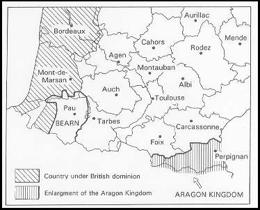
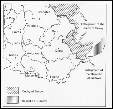
historical changes in territorial boundaries are a prime factor in this type
of research, as can be seen in the cases of Catalonia during the 15th century
and the County of Nice during the 16th and 17th centuries (Fig. 1a, 1b).
It was necessary to take geographical factors
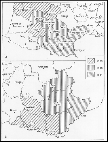
into account because the research had to be organized appropriately to the
scale determined by the characteristics of the event under consideration,
i.e. intensity, location of epicentre and extent of known or presumed effects
(see the research schedule, Fig. 2).
It was necessary to take archival factors into
account because, manifestly, the identification of relevant documents, their
location and the conditions under which they can be consulted depend on the
one hand on the historical and geographical factors just mentioned, and on
the other hand on circumstantial and technical factors related to the scarcity
or otherwise of witnesses at the time in question and the difficulty of reading
and transcribing their accounts.
The second methodological aspect of the project
is directly related to the task of locating and exploiting the relevant
documents. In this context, each participant was asked to draw up as complete
as possible an inventory of all the archive material, manuscript or printed,
that could be of interest to the
research community. This task, which by itself
represents an enormous investment in time, was a reason for very close
collaboration among the different research teams; in particular, this method
enabled the acquisition and comparison of documents of great interest from
a number of sources, such as the Vatican archives and the "Città e
Contado di Nizza" archives kept in Turin, which were consulted by the Italian
team, partly on the recommendation of the French team.
In the same spirit, the investigation of archives
whose consultation yielded negative results was carefully recorded in order
to avoid subsequent duplication of work, such as, for instance, contemporary
manuscript sources (journals, deliberations of town councils, civil registers,
solicitors' registers, religious archives, etc.).
The third methodological aspect of the project
was the insistence on an investigation carried out in large measure either
by consultation of original, contemporary documents that had not hitherto
been consulted, or by returning to already known material, accompanied by
a "genealogy" of sources allowing their rigours criticism.
Having drawn attention to these considerations,
we will now pass to the main results obtained since the beginning of the
project, whether for old documents on which research proved to be fruitless
or for newly discovered information throwing new light on the various seisms.
Summary of Main Results
The results concern essentially investigations
carried out relative to three destructive earthquakes, those of 2nd February,
1428 in the Pyrenees, and of 20th July, 1564 and 15th February 1644 in the
southwestern Alps. Although work on these events has been done in the past,
they remain, to varying degrees, relatively unknown in terms of their epicentral
characteristics, their distant macroseismic effects, or both.
The accent during the research has been placed
on the one hand on the collection of new reports on hitherto unknown points
of reference, and on the other hand on the understanding of reports that
were already known, but were difficult to interpret.
The Catalonian Earthquake of 2nd February, 1428
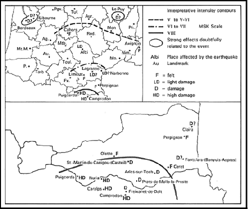
With its epicentre in Spanish Catalonia, this
was one of the major seismic events that affected France during the 15th
century. Reports thus available on localities distant from the epicentral
area (Cerdana) necessitated research over a very wide radius (Fig. 3).
Bordeaux.
Damage inflicted on the cathedral
here, 350 km from the epicentre, continues to pose problems for interpretation.
None of the three main sources, the Gallia Christiana and two 17th century
chronicles (De Lurbe, 1594; De Gaufreteau, 1876-7), enable older sources
to be traced; contemporaneous documents now appear to be lost. Even apart
from a disagreement on the date, some sources giving 1425 (De Gaufreteau,
1876-7; Bellet, 18th) and others 1428 (De Lurbe, 1594; Corbin, 1864; Devienne,
1862; Pontelier, 1672), it is still not possible with certainty to attribute
this damage to the Catalonian seism. The discovery of a contemporary source
(Anonymous, 15th-16th) relative to Nantes mentioning a "terraemotus" in 1427
only adds to the confusion.
Libourne.
A single text (Souffrain, 1806),
apparently from a contemporary source, gives an account of the damage sustained
on 2nd February, 1428, by the belfry of the church of St. Jean and by the
Town Hall. A search of the religious archives (Cordeliers, 15th) on which
this text is based proved fruitless. Our investigations suggest that the
original of this document is now preserved in a personal collection (Besson,
1961) to which, despite repeated requests, we have so far been unable to
obtain access.
Lastly, in view of the contemporary historical
context, which was that the area was under English domination, a survey was
made of the inventories of the archives concerning documents on Aquitaine
for this period, kept in England, but this proved profitless.
Cahors.
Consultation of manuscript sources
led to the acquisition of a new report (Te Igitur, 1874) from the town
archives:
"l'an de notre Senhor M CCCC XXVI le ters
jorn de fevrié que fot Nostra Donna Candeleria fot terra tremol per
tot aquest pais e per tot le realme e plus forta en Araguo..."
In spite of inexactitudes (the reference to
the strong effects in Aragon show that this text in fact describes the earthquake
of 2nd February, 1428 - Gregorian calendar) with respect to both the year
and the day, which are undoubtedly due to a later recession, this new marker
nevertheless seems to be a reliable reference.
Le Puy.
Once again, damage to the religious
buildings here, 330 km distant from the epicentral area, has been identified
in a published chronicle (Duchassaing, 1869) during the recent work. However,
research aimed at verifying the account in the original document has been
unsuccessful in locating any mention of the earthquake in question, which
tends to raise certain doubts. Another source (Denifle, 1897), extracted
from a Latin petition of 1431, and preserved in the Vatican archives, also
specifically mentions damage to the church, but without mentioning the
date:
"Ecclesia Aniciensis in suis structuris propter
frequentes terraemotus plurimum deformationi subjacet...".
This reference will, in the framework of the
project, be reexamined in the original document in order to determine the
context.
Albi.
The mention of Albi had been noted
during earlier investigations, but the recent return to sources and rereading
of contemporary documents made it possible to determine the effects of the
earthquake there, notably from a first report (Vidal, 1897), that had in
part been published previously, and a second (Anonymous, 15tha), so far
unexploited:
1) "l'an M CCCC XXVIII e lo segon jorn de
feb(vrier) fos terra tremolh sus lo solelh levan e duret cal que z quart
d'o(ra) e foc tant gran e ta fort que a dicha de omnes anticax no foc tal
cent ans avian passat ... jazia a la Bre ... Rhonel portet ... catel que
lo porta".
2) "memoria sia a totz aquels que aysso leyran
que l'an que hom contana M CCCC XXVII lo dilus que foc lo jorn de nostra
dona que era a dos del mes de febvrier sus la hora de prima foc gran terratremol
per tot lo monde universal lo qual sot dich que de la mortalitat granda en
sa non foc ausit tant grant et diverses bastimens ne tombero et se estroyssigro
et tropas de cheminayas d'Alby ne tombero".
These two texts, although in places now illegible,
are noteworthy for the details they give on the time and duration of the
shock, and they describe damage at the Porte Rhonel (1) and the collapse
of chimneys in Albi (2). The exegesis of these texts suggests that the collapse
of buildings referred to was not at Albi but at some distance away, perhaps
in Catalonia, as the account from Cahors, in its way, clearly indicates.
Lagrasse d'Aude.
According to Denifle, thanks to a
Latin petition, written in 1432, this locality has become another probable
marker, although certain ambiguities remain on the close relation of the
event described to the Catalonian earthquake:
"Monasterium de Grassa. Ecclesiam et chorum
tam propter terremotum quam nimiam vetustatem ab octo annis citra aliosque
sinistros eventus corruisse".
If the occurrence of an earthquake, combined
with other factors, caused damage to the church, it is nevertheless difficult,
in spite of a verification of the original report referred to by Denifle,
and preserved in the Vatican archives, to establish the responsibility of
the earthquake under such circumstances.
Narbonne.
The same author (Denifle, 1897) as
for Lagrasse reports damage to the church of St. Just in Narbonne:
"Ecclesia Narbonensis in suis structuris
et edificiis in partibus illis invalescentibus terremotibus adeo concussa
et aperta existat quod nisi debite reparetur de illorum totali collapsu in
eventu similium terremotuum forsan de cetero...".
This testimony, taken from a Latin petition
of 1436 preserved in the Vatican archives, is however insufficiently accurate
to make it possible with certainty to impute the responsibility for the damage
to the seism of 2nd February. It could nevertheless be useful to search more
exhaustively, such as in local archives, so as to resolve the ambiguities
left by the witnesses' reports.
Montpellier, Avignon.
Taking into account the research
plan of action established at the beginning of the project, it has not been
possible to incorporate these two markers.
Limoux.
It is again in manuscript archives
(Anonymous, 15thb) that a new testimony has been discovered for this
locality:
"l'an M IIIIC XXVII e a dos febrier foec
gran e terrible terra tremol per tot l'universal mont, per tot l'an o entorn
et majorment lodit jorn que era Nostra Dona de la Candelor per l'espazi de
mieja hora ho entorn en esta vila vizan tot lo mon".
This noteworthy contemporary report gives details
of great interest; in particular, given the situation of Limoux between Perpignan
and Albi, and despite the "terrible" character of the shock, the lack of
damage is of great significance for understanding the long distance propagation
of its effects. On the other hand, the details on the duration of the shocks
"for about a year" show that the context was one of a seismic crisis rather
than of a single shock as has hitherto been the tendency to see it.
In Roussillon and Catalonia, independently of
earlier work, during which a substantial number of reports for these regions
were collected, the research carried out in the framework of the project
has provided additional information concerning essentially previously known
reference localities, such as:
Prats de Mollo.
Here, repairs to the chateau were
delayed owing to the earthquake, "qui cascun jorn continua", according
to a manuscript report dated August, 1428 (A.D.P.O. B/234, 15th). This account
is particularly valuable as it authenticates and verifies the occurrence
of aftershocks and the evocation of a crisis suggested by the Limoux witness.
Arles-sur-Tech.
Here, mention is made (A.D.P.O. B/239,
15th) of the prejudice caused by Bernard, abbot of the monastery of Arles,
who caused auctions to be held illegally outside the town, which, he explained,
took place at the time of the earthquake:
"tempore terremotus et que populus ville
de Arulis exiverat villam choabitando simul".
Perpignan.
Here, the original title was found
of a source too often wrongly quoted by certain authors (Mengel, 1908; Vidal,
1897) as the "Livre de la paroisse St-Jacques de Perpignan", but which in
reality is entitled:
"Aquest libre de las memorias antiques, lesquals
an scrites los preveres de la venerable communitat de Sant Jaume, lesquals
son stades trasletades de un spaltiri esta en lo cor. per mi Johan Buadella.
a 2 de gener de l'any 1541".
This manuscript document recalls the earthquake
thus:
"a dos de fabrer del any mill quatre cents
e vint e vuyt fon gran terratremol com se fahia la benedictio de la sera
lo dia de la Purificatio de Nostra Senyora en que tothom stave spantat".
Barcelona.
A document (A.D.P.O. B/232, 15th)
signed on the 23rd February, 1428 by Queen Marguerite of Aragon, states that
the community of the monastery of Valldonzella, near Barcelona, was unable
to hold a meeting because of the earthquake, which "istis temporibus viget",
suggesting once again the evocation of aftershocks felt at Barcelona and
the assumption of damage in the city.
The Maritime Alps Earthquakes of 1564 and
1644
These earthquakes were responsible for considerable
damage in the hinterland of Nice, in the Vésubie and Tinée
valleys and their environs, but, despite repeated research in the past, they
remain relatively poorly known.
One of the objectives during the project was
to try to resolve certain ambiguities related to the interpretation of the
macroseismic effects in the epicentral area and to the search for information
at some distance from the most strongly affected zones.
The earthquake of 20th July 1564
Although this is regarded in France as without
doubt the most destructive seism that has ever been felt in the southern
Piedmont, very little contemporary evidence has so far been discovered (Fig.
4).
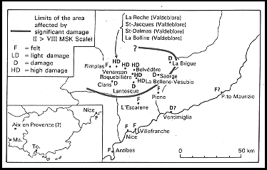
This can be explained, at least in part, by
two important factors. One is the fact that, owing to the disturbances caused
by the wars that were taking place when the earthquake occurred, probably
few accounts were written at the time, and the other is the losses and
destruction of archives caused by the many geopolitical changes in the area,
which passed more than once from French to Italian territory and back
again.
The first step in the research here consisted
therefore in identifying the geopolitical boundaries in the Nice region at
that time, when it was divided among the Duchy of Savoy, the County of Provence
and the Republic of Genoa. This made it possible in particular to reinterpret
the geographical location of certain reference points that had hitherto been
poorly located. Elsewhere, the work was organized so that attention was
concentrated first on the more distant areas, working progressively towards
the epicentral
area.
Distant areas.
Priority was naturally given to the
examination of contemporary sources, but the rewards were meagre relative
to the effort that was invested in the research. Not one of the hundreds
of civil, religious and manuscript sources consulted revealed the least reference
to the seism of 1564; in particular, none of the archives of Marseilles,
Aix-en-Provence, Toulon, Draguignan, Digne or Gap yielded the slightest
detail.
This observation is such as to throw doubt on
the assessment thus far proposed of the focal characteristics of this earthquake,
which, it would be easy to think, would have been felt up to a considerable
distance from the epicentre.
One new discovery nevertheless could concern
Aix-en-Provence, although not all the ambiguities can as yet be resolved.
This is the account taken from a manuscript testimony (Anonymous, Ariège)
entitled "Histoire en forme de journal de ce qui s'est passé en Provence
depuis l'an 1562 jusqu'a l'année 1607", which relates that "le
vingt cinq juillet 1564 fut fait terre tremblant".
The exegesis of this report should make it possible
to authenticate or otherwise the reality of the effects of this shock at
Aix-en-Provence, which could constitute the single marker presently known
at some distance from the epicentral area.
The epicentral area.
In view of all the earlier studies,
an enormous job of selection and compilation of sources had to be undertaken.
Following the example of the Italian work, it was possible to establish the
genealogy of the documentary sources, which confirmed the rarity of contemporary
reports and their uncertain and even contradictory interpretation.
The research, concentrated on the examination
of original sources, brought to light new details concerning the localities
of Roquebillière, Saint-Martin-Vésubie and Villefranche-sur-Mer
(where the seism caused the collapse of the harbour mole). The transcription
of these reports, currently in progress, will undoubtedly make it possible
to detail the macroseismic effects in this area.
This brief account, admittedly provisional,
nevertheless illustrates the great difficulty of access to first order sources.
In this respect, many questions remain unanswered. In particular, whereas
there can be no doubt that destructive landslides occurred, what is the situation
for the estimation of the corresponding macroseismic intensities?
As far as place names are concerned that have
disappeared, such as Sandalim and Rocca Marina, could it be suggested that
they are localities situated between the Col de Tende and the Col de Fenestre
(le Scandail, Mont-Sainte-Marie) exactly in an area where the chronicles
speak of villages being destroyed in the valleys of Gordolasque and Le
Raus?
As far as the effects at sea (tidal waves) reported
at Villefranche, Antibes and Nice are concerned, can they be compatible with
an epicentre now located at more than fifty kilometres inland? Is it possible
to imagine effects here of submarine landslide type?
Is the lack of distant reports compatible with
a high epicentral intensity?
What about the series of seismic movements reported
in several documents (Mst 97; Mercalli, 1897) in May, July and August 1564
(even into 1565), and thus far, in France, attributed to a single shock on
the 20th July?
Such are the questions that at present cannot
be answered and which render the interpretation of this event difficult.
The earthquake of 15th February, 1644
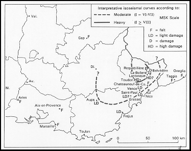
This event, like that of 1564, was distinguished
by its destructive character and occasioned serious damage in the hinterland
of Nice, in the environs of Lantosque, Roquebillière, Toudon and
Belvédère (Fig. 5). Its macroseismic extension is, however,
much better known, thanks to reference points at Aix-en-Provence, Marseilles,
Arles and Gap. The research conducted therefore covered a very wide range
of action. As usual, the greater part of the work was undertaken on collections
of contemporary manuscript archives. It has to be admitted, however, that
few new reports can be added to the list of
those already known, probably because of the
historical context at that time.
Nevertheless, a certain number of new points
can be presented.
Aups.
The acquisition of a copy of the
original document (A.M. Aups, 17th) confirms damage to the village church,
where "il s'est fait plusieurs ouvertures aux murailles".
Arles.
Exegesis of the most reliable text
(Veran, 1802) excludes the possibility that the intensity was very high
here.
Toulon.
Not an earthquake, but a hurricane
is referred to here (A.M. Toulon, 17th), in February 1644, which caused the
pinnacle of the church of the Capuchins to collapse.
Grasse and Fréjus.
No new allusion has been found to
confirm the damage mentioned to the churches of these two villages. The
possibility cannot be excluded, however, that there was confusion between
damage caused by the earthquake and that caused by a violent storm, as is
suggested by the report at Toulon.
Chateauneuf-de-Contes.
Reinterpretation of the documentary
source (Bouche, 1664) shows that the intensity here cannot have been as great
as previously believed.
Venanson.
A recent work (Latouche, 1932) has
reported that, according to archives that cannot now be found:
"le 15 février, 1644, l'église
s'écroula et les plus fortes secousses se firent sentir dans la
vallée de la Vésubie".
Saint-Martin-d'Entraunes.
Research in progress should shed
light on the exact nature of a "disastre" mentioned in contemporary manuscript
archives (A.D.A.M., 17th)
Conclusions
These then, concisely summarised, are the principal
results achieved during the various phases of research undertaken since the
beginning of the project. It has to be said that the results do not measure
up to the effort invested during this period, even if certain of them constitute
an extremely important capital gain. It is probable that the reasons for
this semisuccess reside, not in the methodology adopted during the project,
but rather in the historical contexts of the 15th, 16th and 17th centuries,
during which these events took place. In contrast to the succeeding ones,
these centuries are characterized by extreme rarity of contemporary accounts,
which comes on top of the already considerable problems of legibility and
transcription of the original documents.
Nevertheless, the negative scrutinies which
also serve the ends of research, enabling, during later investigations, the
duplication of work to be avoided, will not be forgotten. Lastly, along with
the two principal subjects tackled during the project, the progress, fruit
of collective labour, made with respect to other events, such as the seisms
of 1329, 1336, 1545, 1608, 1627, 1660, etc., should not be passed over in
silence.
References
A.D.A.M. 17th. Letter of Monseigneur
l'Evêque de Glandèves. Manuscript, Archives, Alpes-Maritimes
Department, E dépot 58, St-Martin-d'Entraunes, FF4.
A.D.P.O. B/232, 15th. Registre XV de la
Procuration royale, (confirmation de la vente par la reine Marguerite des
lieux de Claira, Eus, le Soler, Castellnou, Bellpuig). Manuscript, Departmental
Archives, Pyrénées-Orientales Department, série B 232.
A.D.P.O. B/234, 15th. Registre XXII de la
Procuration royale, (réparations du château de Prats-de-Mollo).
Manuscript, Departmental Archives, Pyrénées-Orientales Department,
série B 234.
A.D.P.O. B/239, 15th. Notule de Gabriel Resplant,
notaire à Perpignan. Manuscript, Departmental Archives,
Pyrénées-Orientales Department, série B 239.
A.M. Aups, 17th. Délibérations
du conseil de la commune fol. 308-309. Manuscript, Communal Archives, Aups,
registre BB2.
A.M. Toulon, 17th. Délibérations
du conseil de ville, fol. 280, 284. Manuscript, Municipal Archives, Toulon,
registre BB58.
Anonymous, 15th-16th. Chronique (Histoire
des Rois de France), fol. 85. Manuscript no. 728, Municipal Library, Bordeaux.
Anonymous, 15th a. Cartulaire AA1, fol. 35
and 41. Manuscript, Communal Archives, Albi.
Anonymous, 15th b. Cartulaire AA2, fol. 77.
Manuscript, Communal Archives, Limoux.
Bellet, Abbé, 18th. Notes et
mémoires historiques sur Bordeaux et la Guyenne; phénomènes
arrivés à Bordeaux depuis 1373. Manuscript no. 828/5, Municipal
Library, Bordeaux.
Besson, M., 1961. Le droit de mairie et
l'Hôtel de Ville de Libourne. Revue historique et archéologique
du Libournais (private archives of Decazes cited).
Bouche, H., 1664. Histoire chronologique
de Provence. Aix-en-Provence.
Cadiot, B., 1979. Le séisme nissart
de 1564. Les effets en France du séisme catalan de 1428. In: Vogt
J. (Editor), Les tremblements de terre en France, BRGM Mémoire 96,
Orléans, pp. 166-171; 172-174.
Corbin, Abbé, 1864. La cathédrale
de Bordeaux; étude historique et archéologique par un prêtre
du diocèse. Bordeaux.
Cordeliers, 15th. Fonds des Cordeliers de
Libourne, Série H. Manuscript, Departmental Archives, Gironde Department.
De Gaufreteau, J., 1876-7. Chronique bordelaise
(1240-1599), t.1. Jules Delpit. (Editor). Bordeaux.
De Lurbe, G., 1594. Chronique bordelaise.
Bordeaux.
Denifle, H., 1897. La désolation des
églises, monastères et hopitaux en France pendant la guerre
de Cent ans, t.1. Paris.
Devienne, D., 1862. Histoire de Bordeaux,
t. 2. Bordeaux.
Duchassaing, A., 1869. Le Livre de Podio
ou Chronique d'Etienne Médicis, bourgeois du Puy, t. 1. Le Puy.
Gallia Christiana, 1656. Ecclesia burdigalensis,
vol. 1, col. 841.
Lambert, J., 1989. The 1427-1428 Catalan
earthquakes and the 1564-1664 Maritim Alps earthquakes. State of art and
first set of research. BRGM, Orléans, CEC Project RHISE, Progress
Report.
Lambert, J., 1990. Project: Review of historical
seismicity in Europe. Révision de séismes majeurs anciens.
Partie française (phase 2). BRGM, Orléans, CEC Project RHISE,
Progress Report.
Latouche, R., 1932. Histoire du comté
de Nice. Paris.
Mengel, O., 1908. Monographie des "Terratremols"
de la région catalane. Bulletin de la Société Ramond,
t. 43, Toulouse.
Mercalli, G., 1897. I terremoti della Liguria
e del Piemonte. Napoli.
Mst 97 Nice. Manuscript no. 97, fol. 3739,
Municipal Library, Nice.
Pontelier, 1672. Continuation de la Chronique
bourdeloise commencée à l'année 1620. Bourdeaux.
Sirène, 1991. Fichier de sismicité
historique de la France. BRGM/CEA/EDF.
Souffrain, J.B., 1806. Essais,
variétés historiques et notices sur la ville de Libourne et
ses environs, t.1. Bordeaux.
Stucchi, M., 1988. The CEC Project "Review
of Historical Seismicity". In: C. Margottini and L. Serva (Editors), Proc.
IAEA Workshop on Historical Seismicity of Central-Eastern Mediterranean Region,
Roma, 27-29 October 1987, pp. 333-337.
Te Igitur, 1874. Manuscript, Cahors town.
Société des Etudes littéraires, scientifiques et artistiques
du Lot, acte no. 62. Cahors.
Véran, P., 1802. Répertoire
raisonné sur l'Histoire d'Arles. Manuscript no. 721, Municipal Library,
Arles.
Vidal, A., 1920. Phénomènes
météorologiques anormaux. Comptes rendus du congrès
des sociétés savantes de Paris et des départements,
Strasbourg, Section Sciences. Paris.
Vidal, P., 1897. Histoire de la ville de
Perpignan. Paris.
[Top]
[Vol.1]
[Vol.2]
[Deliverables and queries]
[Presentation]
[Homepage]