EC project "Review of Historical Seismicity
in Europe" (RHISE) 1989-1993
|
|
[Deliverables and queries] [Presentation] [Homepage] |
Introduction
During the period 1427-1428 a series of earthquakes produced
important damage in an area of the Eastern Pyrenees in Catalonia. It is known
(Olivera et al., 1992) that the main events of the series were that of 15
March 1427, with main damage in the village of Amer, that of 15 May 1427,
which destroyed the town of Olot and that of 2 February 1428 with epicenter
located more to the NW between Puigcerdà and Camprodon (see Fig.1).
The severity (in intensity and extension of damage) of these
events had caused many catalan historians to be interested in their study.
Thus, around 1550, the historian Jeroni Pujades transcribed and summarized
a set of documents on the effects of the earthquakes in the bishopric of
Girona. This manuscript, known as "Flosculi", is now at the Biblioteque
National in Paris and was published by Giralt (1889) and Montsalvatge
(1906).
As said, the 1427 earthquakes destroyed the village of Amer
and an important part of the town of Olot. Because of this, some local historians
such as Bolós (1841), Paluzie (1860) and Danes i Torras (1937) carried
out various studies on their effects. The above mentioned sources are essentially
the origin of the data on these events contained in the main earthquake
catalogues, in particular that of Fontserè and Iglésies (1971),
which is a valuable data collection on earthquakes occurred in Catalonia,
Valencia and Balearic Islands. This compilation should be considered as the
starting point for any research on historical seismicity of these regions,
since it includes a large amount of data together with complete references.
More recently, new information sources coming from Spanish archives have
been brought by Rubió (1961) and Prades (1989), while Riu (1980) and
Del Valle (1990) have contributed with new data from foreign archives. Based
on data contained in the compilation by Fontserè and Iglésies
(1971), Cadiot (1979) and Banda and Correig (1984) published isoseismal maps
for the February 2, 1428 earthquake. This earthquake took place in a region
already damaged by the former events of the series and there is evidence
that some of their reported effects could possibly be mixed (Olivera et al.,
1991).
The purpose of this paper is to present the results of the research
carried out on the 1427 events, within the frame of the CEC project Review
of Historical Seismicity in Europe (RHISE). Here the seismic period 1420-1427
is reviewed as a contribution to the programme for hazard evaluation in
Catalonia.
Archive research
The starting point of our research has been the Fontseré
and Iglésies (1971) compilation. The research work has been organized
in two parts.
Critical review of Fontserè and Iglésies
catalogue
A critical review of the information contained in the Fontserè
and Iglésies catalogue has been carried out by a systematical
classification and quality evaluation of sources. The majority of sources
considered in this catalogue are published accounts, not contemporary to
the events. Research on these secondary sources has been carried out in the
following archives and libraries in Barcelona: Biblioteca de Catalunya,
Biblioteca de la Secció d'Estudis Medievals de la Institució
Milà i Fontanals (CSIC), Biblioteca de la Universitat de Barcelona,
Biblioteca de la Facultat d'Història de la Universitat de
Barcelona; and the Biblioteque National in Paris.
Great effort has been devoted to the investigation on how
information was transmitted through different secondary sources and trying
to recover the references to original sources contemporary to the earthquakes.
Many multiplicities in pieces of information that actually come from the
same single source have been confirmed.
Retrieval of sources contemporary to the events used by former
compilers and search for new original documents
Abundant contemporary reports were expected to exist given the
particular organization of Catalonia during the Middle Age, and in particular
concerning the central archives of the Crown (Arxiu de la Corona
d'Aragó) that has a section (Cancilleria Reial) in which a
copy of all documents sent by the king are still preserved.
The sources that were investigated are of different types: 1)
historiographic records (royal, noble and municipal chronicles, monastic
and urban annals, diaries); 2) Royal Chancellor Registers (in Catalonia they
begun in 1250 and provide balanced, reliable information on all the regions
in the kingdom); 3) municipal records (Council agreement books, public
announcements, Clavaria -accounting books-, letter registers); 4)
ecclesiastical records (pastoral visits, Comunium -in which the register
of letters from the bishop is kept-, books on cathedral works, capitular
acts); 5) lawsuit record; 6) calendars; 7) notaries' documents (wills, loans,
purchase of land for rebuilding).
Intensive search for contemporary sources was undertaken in
archives in the following towns: Barcelona (Arxiu de la Corona d'Aragó,
Institut Municipal d'Història, Arxiu Diocessà,
Arxiu Capitular and Arxiu Històric de Protocols), Girona
(Municipal, Diocessà and Capitular), Olot
(Municipal), Camprodon (Municipal), Sant Joan de les Abadesses
(Municipal), Seu d'Urgell (Municipal, Diocessà and
Capitular), Vic (Municipal, Diocessà and Capitular),
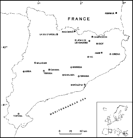
Cervera (Municipal), Lleida (Municipal and Capitular),
Balaguer (Municipal), Tàrrega (Municipal), Terrassa
(Municipal), Manresa (Municipal), Igualada (Municipal),
Tortosa (Municipal) and Madrid (Archivo Histórico
Nacional.).
A highly rich source that has been investigated are the Visites
Pastorals of the Girona diocese (Riera-Melis et al., 1993); these are
detailed written accounts of the visits to ecclesiastic properties (monasteries,
convents, churches, hermitages, chapels). As this visit took place four years
after the earthquakes (in 1432) it is not possible to distinguish between
the effects of the different events of the series. Nevertheless, it provides
a detailed description of damages caused to churches over a wide area. It
gives a picture of the extension and severity of the global damage produced
by the complete seismic crisis and in some case could be of great help to
avoid over and underestimation of intensity.
Critical revision and classification of the sources contained
in Fontserè and Iglésies (1971) catalogue concerning 1427 events,
together with the analysis of the new pieces of information that have been
found, allow us to see how the information in some primary sources was
transmitted to the catalogue and how some original sources were never consulted.
Data analysis and results
In the data analysis and interpretation which follows only
documentary sources generated prior to February 1428 have been considered
in order not to confuse and mix the effects of the 1427 events with those
of 1428, in particular with the large one of 2nd February 1428. Critical
revision and analysis of the sources yield a re-evaluation of the earthquakes
which occurred during the period 1420-1427.
In this analysis different methodological criteria have been
followed. An important point is that any event which had been previously
catalogued on the basis only of secondary sources, from which it is not possible
to identify the original primary source, will be considered as a fake earthquake.
Also, given the historical context of Catalonia in the 15th century, when
there was a quite evolved administrative system, it is reasonable to consider
that a large earthquake has to be reported in more than one document. Thus,
if a single source described important damage in a given area and no
complementary documents supported this description then we looked for possible
duplications of events due to confusion of data in successive
transcriptions.
In the analysis of the information sources it should be taken
into account that Barcelona was the most important city in the country; it
was the residence of the king and held the headquarters of the administration
besides being a big commercial and economic centre. For all these reasons
a much larger amount of written accounts were generated in this town compared
with the other areas of the country.
Therefore, a quite large amount of pieces of information on
earthquakes felt in Barcelona have to be considered to be effects of distant,
moderate events occurred in the Pyrenees, even though there are no documents
reporting them from the epicentral area. This was not considered properly
in some former compilations which included epicenters in Barcelona on the
basis of these pieces of information. Local information referring to Barcelona
are to be used cautiously, considering that even today events of epicentral
intensity V, in Pyrenees regions further than Amer and Olot, are often felt
in Barcelona.
The new EMS-92 scale (Grünthal, 1993) has been used to
assess intensity to the sites where damage is reported. One of the main problems
in intensity assessment from historical records is that damage often refers
to a single monumental building, involving two main problems: one, the assessment
of vulnerability class and, second, the difficulty to define quantities
(percentage) of grades damage, which cannot be defined on a statistical
basis.
Seismic activity during the period 1420-1427
With the above considerations the documents referring to the
period 1420-1427 have been analyzed. The results of this analysis are summarized
in Tab. 1 together with the corresponding conclusions from previous studies
as contained in the Fontserè and Iglésies (1971) and Instituto
Geográfico Nacional (IGN) (1991) catalogues.
From the 20 events analyzed, 7 have been considered to be fake
earthquakes, one of them (1426.03.03) having been previously catalogued as
intensity VII.
Most of these fake earthquakes were product of data confusions
and then duplications of other events of the series. In some other cases
they had been catalogued on the basis of dated descriptions of processions
or other religious celebrations which actually were social reactions to former
earthquakes.
Only two events of the series were destructive earthquakes:
that of 15 March 1427 with epicenter in the village of Amer (Io= VIII-IX)
and that of 15 May 1427 (Io = IX) with epicentre in the town of Olot. These
two earthquakes have been studied in some detail and the results are presented
further on. As seen in Tab. 1 the epicenter and maximum intensity that has
been obtained in this study on the basis of only primary sources do not differ
very much from the catalogued data in Fontserè and Iglésies
(1971) and in the catalogue from the Instituto Geográfico Nacional
(1991). Critical review and analysis of primary sources confirm the location
and the severity of these earthquakes.
Many of the minor events listed in Tab. 1 are mentioned in one
source in Barcelona (Manual de Novells Ardits, which compiles official
registers from the municipality of Barcelona). Some of them were probably
more strongly felt in the town of Girona and its bishopric as they are reported
as foreshocks without references to damage, in a letter from the members
of the Council of Girona to the king in which they informed about the damages
produced by the main shock of 15 March 1427 that destroyed the village of
Amer. Some later events are only mentioned in the above referenced source
from Barcelona and there is not information related to Girona territories.
It is nevertheless reasonable to also consider these events as foreshocks
located near Amer, at the same epicentral area as the main shock, rather
than near Olot as considered in the IGN catalogue.
|
|
|
|
|
||||
|
|
|
|
|
|
|
|
|
| 1420 |
|
|
|
||||
| 1421 |
|
|
|
||||
| 1424.03.04 |
|
|
|
||||
| 1426.03.03 |
|
|
|
|
|
||
| 1427.02.02 |
|
|
|
||||
| 1427.02.23 |
|
|
|
|
|
||
| 1427.03.01 |
|
|
|||||
| 1427.03.02 |
|
|
|
|
|
||
| 1427.03.04 |
|
|
|
|
|||
| 1427.03.07 |
|
|
|
|
|||
| 1427.03.13 |
|
|
|
|
|
||
| 1427.03.14 |
|
|
|
|
|
||
| 1427.03.15 |
|
|
|
|
|
|
|
| 1427.03.19 |
|
|
|
|
|
||
| 1427.03.21 |
|
|
|
|
|
||
| 1427.03.22 |
|
|
|
|
|
||
| 1427.04.22 |
|
|
|
|
|
||
| 1427.04.23 |
|
|
|
|
|
||
| 1427.05.15 |
|
|
|
|
|
|
|
| 1427.12.25 |
|
|
|
|
|
|
|
The information available for the last event (1427.12.25)
contradicts the intensity VIII in Olot assigned in the IGN catalogue. The
only reliable source (Llibre de Solemnitats de Barcelona) reports
that the event was felt in Barcelona. As explained before, it is then reasonable
to think that the epicenter was in the Olot region, but the intensity must
have been much lower.
The earthquake of 15 March 1427
Only primary sources dated prior to 15th May are considered
in order to reliably determine the epicentral location and intensity of the
earthquake without any confusion with the next large event. Some of these
sources, in particular the above mentioned letter from the members of the
Council of Girona to the king, accurately dates the event and gives a detailed
description of the destruction of the village and monastery of Amer.
With the available information on sites where damage took place,
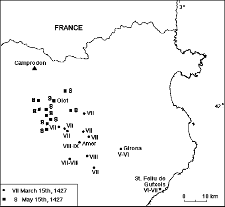
intensity values have been assessed and they are represented in Fig. 2. Reported
damage is concentrated close to Amer, town in which maximum destruction occurred.
It would not be reliable to draw isoseismals with these data
points and, in fact, they are not necessary to define epicenter, which is
assumed to be in Amer, with an epicentral intensity VIII-IX.
An apparently discordant data point appears in St. Feliu de
Guíxols, on the coast, at about 40 km from Amer. Two newly found documents
(two letters from the king Alfons el Magnànim, one to the General
Governor and the other one to the members of the councils of the village),
which are reliable under the historical point of view, indicate that there
was some damage produced by the earthquake to the city walls. Being cautious
about this information, and given the distance of this locality to the epicentre,
an intensity VI-VII can be assigned.
The earthquake of 15 May 1427
For the study of this earthquake historical accounts have been
analyzed with the same criteria as above, considering only primary sources
with a date prior to 2nd February 1428.
Fig. 2 also shows the sites for which data are available from
primary sources describing damage. Intensity IX is assigned to the town of
Olot, which, according to the documents, was destroyed so that the king gave
permission to rebuild it in another place (Riera-Melis et al., 1992). A number
of points of intensity VIII are located around Olot, extending mainly to
the South as far as 15 to 20 km. There is no damage record outside this
area.
No isoseismals can be drawn with these data but given that the
descriptions of the most severe damage corresponds to the town of Olot, epicentre
can be assigned with a reasonably good accuracy to this locality with Io
= IX.
Discussion
Quantified the intensities for the 15 March and 15 May events
from unambiguous primary data we take up again the information issued from
the analysis of the Pastoral Visit of 1432 to the diocese of Girona
(Riera-Melis et al., 1993). In that analysis data from 387 churches and other
ecclesiastical buildings inspected by the visitor were identified, located
and classified according to degree of earthquake damage (completely devastated,
destroyed in a very large proportion, partially destroyed, with some form
of slight damage and with no noticeable effects). As the Visit was
carried out in 1432, the reports of damage have to be considered to correspond
to the accumulated effects of the 1427-1428 series. This Visit should
be taken only as a complementary data set to be interpreted together with
pieces of information confidently ascribable to the individual events.
Using EMS-92 scale, a first attempt to assess intensity has
been made from the data reported in the Pastoral Visit. Given that
a single building is referred to on each site and that vulnerability class
is difficult to assess then large uncertainties in intensity evaluation appear.
In Fig. 3 intensity points from the Visit are plotted together with
the contour lines surrounding the areas of intensity equal or larger than
VII for the earthquake of 15 March and equal or larger than VIII for the
earthquakes of 15 May. The two stars represent the assigned epicenters. Within
these contouring areas of damage there is a quite good agreement between
intensities assigned with sources mentioned in the study of the individual
events and those estimated from the descriptions of the Pastoral
Visit.
It is interesting to point out that there is a site reported
in the Visit quite far from the epicentral areas, towards the Southeast,
near the coast, with intensity VI-VII. This site is located at 10 km distance
from the "discordant" point (Sant Feliu de Guíxols) which was described
in the 15 March study (see Fig. 2). Therefore there is an agreement between
both data points.
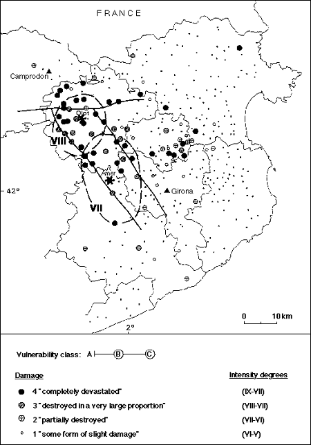
Fig. 3 - Intensity points obtained from the Pastoral Visit
to the Diocese of Girona of 1432 together with contours of intensity VII
for the 15 March 1427 earthquake and contours of intensity VIII for the 15
May 1427 earthquake. Stars represent the epicenters of the two events. Small
dark points indicate sites with explicit unnoticeable effects. Possible
associated tectonic accidents are sketched with solid lines.
A number of points from the Visit located to the North
of Girona remain unexplained and they will have to be analyzed together with
the data from the 1428 earthquake.
In Fig. 4 the Amer-Brugent fault system (NW-SE oriented) interrupted
by the Vallfogona thrust (W-E oriented line) are sketched (Goula et al.,
1992). The 1427 earthquakes can be associated to this NW-SE system; the rupture
evolved from South (15 March) to North (15 May).
Conclusions
The seismic period 1420-1427 in the Pyrenees has been revised
through an exhaustive and critical archivistic research. From the 20 events
contained in the most used Spanish compilations, 7 have been found to be
fake earthquakes, one of them (3 March 1426) previously catalogued as Io=
VII. The intensity of one earthquake previously catalogued as VIII (25 December
1427) has been lowered to less than VI. Mislocations of some low intensity
events have also been corrected. Only two events of the series have been
found to be destructive: that of 15 March 1427 and that of 15 May 1427.
Original primary sources contemporary to the events have been
analyzed to assess point intensities, according to the EMS-92 scale, for
the 15 March 1427 and 15 May 1427 earthquakes and epicentral areas for both
events have been delimited.
The epicentre of the 15 March earthquake is located in Amer,
with intensity VIII-IX while the 15 May epicenter is located in Olot, with
intensity IX.
The results from this study confirm the severity of damage in
Catalonia of these two events and are of great interest for the evaluation
of the earthquake hazard in Catalonia and the South of France.
References
Banda, E. and Correig, A., 1984. The Catalan earthquake of
February 2, 1428. Eng. Geol., 20: 89-97.
Bolós, F., 1841. Noticia de los extinguidos volcanes
de Olot y de sus inmediaciones hasta Amer, y de los nuevamente descubiertos,
todos en la provincia de Gerona. Barcelona.
Cadiot, B., 1979. Les effets en France du séisme Catalan
de 1428. In: J. Vogt (Editor), Les tremblements de terre en France, BRGM
Mémoire 96, Orléans, pp. 166-172.
Danes i Torras, J., 1937. Pretèrits Olotins.
Olot.
Del Valle, C., 1990. Una fuente hebrea sobre los terremotos
de Gerona de 1427. Revista de Girona.
Fontserè, E. and Iglésies, J., 1971.
Recopilació de dades sísmiques de les terres catalanes entre
1100 i 1906. Fundació Salvador Vives Casajuana, Barcelona, 547
pp.
Giralt, E., 1889. Flósculi. Revista de Girona, pp.
55-82.
Goula, X., Olivera, C., Escuer, J., Fleta, J. and Bousquet,
J.C., 1992. Neotectonics and seismicity of the area of the seismic crisis
of 1427-1428 in Catalonia. In: A. Roca and D. Mayer-Rosa (Editors), Proceedings
of the XXII ESC General Assembly and Activity Reports 1988-1990, Barcelona,
t. 1, pp. 333-357.
Grünthal, G. (Editor), 1993. European Macroseismic Scale
1992 (up-dated MSK-scale). Cahiers du Centre Européen de
Géodynamique et de Séismologie, Luxembourg, 7, 79
pp.
Instituto Geográfico Nacional, 1991. Earthquake Database
for the Iberian Peninsula.
Montsalvatge, F., 1906. Colección Diplomática
del Condado de Besalú, III. Imp. Juan Bonet, Olot.
Olivera, C., Banda, E. and Roca, A., 1991. An outline of
historical seismicity studies in Catalonia. Tectonophysics, 193:
231-235.
Olivera, C., Riera, A. and Roca, A., 1992. Study of the 1427
earthquakes in Catalonia. In: A. Roca and D. Mayer-Rosa (Editors), Proceedings
of the XXII ESC General Assembly and Activity Reports 1988-1990, Barcelona,
t. 1, pp. 327-331.
Paluzie, E., 1860. Olot y su comarca, sus extinguidos volcanes,
su historia. Barcelona.
Prades, I., 1989. Els terratrèmols de la sèrie
olotina i el cas de la vila d'Amer. Quadern de la Selva-2 Sta. Coloma de
Farners, s.d., pp. 103-112.
Riera-Melis, A., Escuer, J., Fleta, J., Goula, X. and Olivera,
C., 1992. The 1427-28 earthquakes in Catalonia: Historical traces and geological
context. Excursion guide text. In: A. Roca and D. Mayer-Rosa (Editors),
Proceedings of the XXII ESC General Assembly and Activity Reports 1988-1990,
Barcelona, t. 1, pp. 387-399.
Riera-Melis, A., Roca, A. and Olivera, C., 1993. Analysis
of the Pastoral Visit of 1432 to the Diocese of Girona for the study of the
seismic series 1427-1428 in Catalonia. In: M. Stucchi (Editor), Materials
of the CEC project "Review of Historical Seismicity in Europe", 1, Milano,
pp. 161-172.
Riu, M., 1980. Una font polonesa per a l'estudi del
terratrèmol de 1427. Annals de l'Institut d'Estudis Gironins, Girona,
XXV, 1: 357-362.
Rubió, J., 1961. Documents sobre els terratrèmols
de 1427-28 a terres de Girona, Miscel.lània Fontserè, Ed. Gustavo
Gili, Barcelona, pp. 357-375.
[Top]
[Vol.1]
[Vol.2]
[Deliverables and queries]
[Presentation]
[Homepage]