EC project "Review of Historical Seismicity
in Europe" (RHISE) 1989-1993

|
[Deliverables and queries] [Presentation] [Homepage] |
Introduction
It is of fundamental importance to collect all
available information to reconstruct the maximum ground motion which occurred
at archaeological sites in the proximity of which critical facilities are
planned to be erected (Gürpinar and Margottini, 1994).
As Syria is rich in archaeological sites, field
research was carried out to define the historical earthquake effects at
archaeological sites located in north-western Syria along the northernmost
part of the Syrian Lebanese Fault (SLF). This fault, which represents the
northern extension of the Dead Sea transform fault system in Syria, is one
of the most seismogenic fault zones in the region.
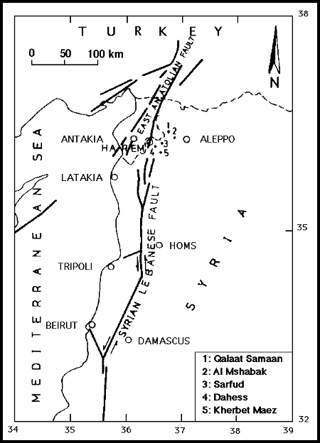
This study deals with five examples of
archaeological sites. Fig. 1 shows location map of these monuments. This
study involves:
- desk work oriented to define the archaeological
sites damaged by earthquakes, their names during their life-times, time of
their foundation and date of latest reconstruction;
- field investigation to define the type of
earthquake damage and to distinguish seismic effects from non-seismic ones.
History
The history of archaeological sites investigated
is briefly reviewed as follows:
- Qalaat Samaan (citadel of St. Simeon): situated
on a limestone hill, it has splendid Byzantine monuments of the 5th century
AD.
The cathedral surrounding the pillar, on top
of which St. Simeon lived, is considered among the largest churches in the
ancient world. The church was converted into a stronghold citadel during
Sayf Ad Dawla Al-Hamadani's rule. There are ruins of a city on the slope
of the hill (Zakariyya, 1984; Sha'ath, 1983).
- Qasr Al-Mshabak: located between Aleppo and
Qalaat Samaan (3 Km. far from Daret Ezzeh), it has the shape of a rectangular
church and probably it dates back to the Byzantine era. Unfortunately, historical
information on this site is lacking.
- The archaeological sites in Barisha mountain
(3 sites): located north-west of Idlib near the Turkish-Syrian border, they
contain more than 200 of the so called "Dead Towns". These sites flourished
during the Byzantine time and, for instance, they were described by Yakut
al-Hamoui (1906), a geographer and historian who lived between 1178 and 1229,
and occasionally visited them (Zakariyya, 1984). Among them, Sarfud, Kherbet
Maez and Dahess are to be mentioned. The several churches, monasteries and
temples in Barisha reflect the prosperous life enjoyed by the population.
There are only few references available on these sites, poor in details
(Tchalenko, 1953; Al-Satea, 1975).
Tab. 1 summarises the main characteristics of
the five sites.
|
|
|
|
|
|
|
|
|
|
|
|
Qalaat Samaan (Citadel) =
St. Simeon |
Byzantine | Large size blocks of limestones |
526, 1137, 1170, 1719, 1822\ |
Cathedral partially restored. Ruins of a city on the slope of the hill |
- Fractures
- Horizontal shifting - Twisting - Waving |
2 2 - 3 |
|
|
|
Qasr Al-Mshabak (Palace) | n.d. (Byzantine?) | Medium size blocks of limestones | Church ceiling completely destroyed |
- Horizontal shifting - Waved walls - Extension |
- 4 5 |
|
|
|
|
Dahess (Ruins) | n.d. | Large size blocks of limestones | Most of earthquakes which hit Antioch | In ruinous state with remaining individual wall |
- Rocking
- Horizontal shifting - Waving |
6
7 7 |
|
|
|
Sarfud = Al-Braeje (Convent) | Byzantine | Large size blocks of limestones | Most of earthquakes which hit Antioch | Partly destroyed |
- Fractures
- Horizontal shifting - Tilting |
8 9 - |
|
|
|
Kherbet Maez (Ruins) | Byzantine | Large size blocks of limestones | Most of earthquakes which hit Antioch | Ruined considerably |
- Deformation
- Horizontal shifting - Waving |
10 - - |
|
Seismological and seismotectonic setting
The area where Samaan and Barisha mountains
are located is very close to the Syrian Lebanese fault, and also close to
another very active seismic zone, the Eastern Anatolian fault (EAF), outcropped
to the north of the area (Fig. 1). The SLF, northern part of Dead Sea fault
(DSF) is a N-S trending interplate transform fault between the Arabian plate
(east) and the Sinai plate (west). It displays a left lateral displacement
with minor components of extension and compression. Morphological and geological
evidences for neotectonics along the SLF were evaluated by Radwan and Al-Najjar
(1991). Moderate to large earthquakes occurred along the entire extension
of this fault (Ministry of Electricity, 1988; Ambraseys and Barazangi, 1989;
Sbeinati, 1994).
The area of Samaan and Barisha, like other areas
along the DSF, seems to be stricken by large earthquakes (M >= 6.5) with
long return period (200-350 years) (Ambraseys and Barazangi, 1989).
Evidences of possible seismic damage
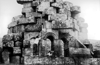
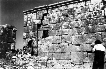
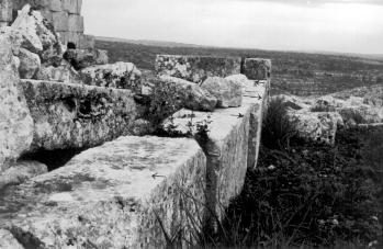
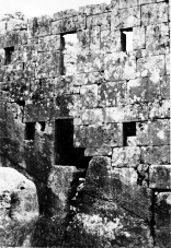
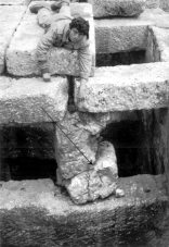
Very frequent fracturing in the walls of these
monuments can be observed. The origin of this fracturing is uncertain, i.e.
they can be interpreted as effects of earthquake(s) or of deterioration of
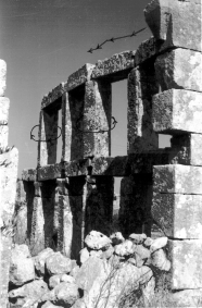
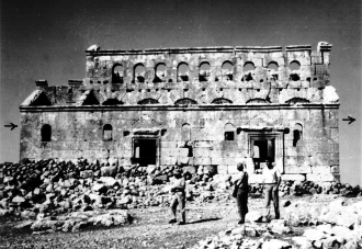
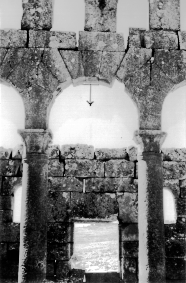
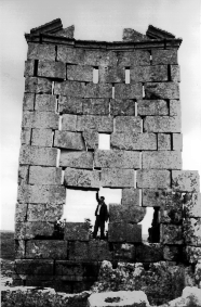
their structure (Fig. 2 and 9). The extension observed in Fig. 5 can be
considered as a characteristic feature of the effects of seismic ground motion.
An interesting example is displayed in Fig. 7, where the rocking of the western
wall (Dahess) can be considered as a clear effect of seismic ground motion.
Other evidence is shown in Figs. 3, 4, 6, 8 and 10. In Tab. 1, column 7 "Type
of evidence", many types of possible seismic damage, observed at the
investigated monuments, are listed.
Concluding remarks
The examples shown suggest that the study of
archaeological sites can be a useful tool in understanding seismic history.
Archaeological evidence can be used to establish,
in a very preliminary way, an upper limit of the seismic effects recorded
at the site, if one assumes that:
- today evidence corresponds to the original
earthquake record;
- the earthquake struck the site when it stood
in good conditions and its vulnerability was the lowest possible.
If these two circumstances are not met, the
archaeological evidence should be assumed as the result of lower
shakings.
Following this point, Tab. 1 presents a very
preliminary determination of the maximum macroseismic intensity which in
principle might be correlated with the evidence rise.
In short, investigation on archaeological sites
may give preliminary information on seismic effects, though they bear great
uncertainties which necessitate concerted efforts to improve the reliability
of the results.
Acknowledgements
This study is part of a research project entitled
"Seismic Data for the Siting and Site Re-Validation of Nuclear Facilities"
(No. 6247/RB), funded by International Atomic Energy Agency at Vienna. The
authors express their sincere gratitude to the Director General of Syrian
Atomic Energy Commission for his constant encouragement and support. We would
also like to thank M. Stucchi and P. Albini for their valuable suggestions
and remarks.
References
Al-Hamoui,Y., 1906. Moujam al-bouldan. Cairo
[n. pub.].
Al-Satea, A. and Al-Satea, F., 1975. Al-Dalil
al-Akhdar lil siyyaha wa al-athar. Dar al-Fukr, Damascus.
Ambraseys, N. and Barazangi, M., 1989. The
1759 earthquake in the Bekaa Valley: Implications for earthquake hazard
assessment in the Mediterranean region. Journal of Geophysical Research,
94, B4: 4007-4013.
Gürpinar, A. and Margottini, C., 1994.
Possible evidences of past seismic ground motion(s) in the historical town
of Hatra (Central Mesopotamia). Proc. of the Regional Workshop on
Archaeoseismicity in the Mediterranean region, Damascus (in
press).
Ministry of Electricity, 1988. Report of
macroseismic research in areas of NPP sites location (in English),
Aleppo.
Radwan, Y., Al-Najjar, H. and Darawcheh,
R., 1991. Investigations of active tectonics along the major faults in Syria
using geomorphic techniques. In: S. Riad, A. Morelli and M. Miele (Editors),
Proc. of the First Regional Seminar on Earthquake Research Activity and Risk
Assessment in the Mediterranean region, Cairo.
Sbeinati, M. R., 1994. Evidences of seismic
effects on selected archaeological sites in Syria. Report on scientific field
study, Atomic Energy Commission of Syria, Damascus, pp. 4-28 [not
public].
Sha'ath, Sh., 1983. Qalaat Samaan. The
Directorate General of Antiquities and Museums, Damascus.
Tchalenko, G., 1953. Villages antiques de
la Syrie du Nord. Librairie Orientaliste, Paris.
Zakariyya, W., 1984. Jawala athariyya fi
baed al-bilad al-chamiyya. Dar al-Fukr, Damascus.
|
|
|
|
| Fig. 9 - Breakage and tilting of the pillar that supports a water reservoir, Sarfud (Al-Breige) site. |
