EC project "Review of Historical Seismicity
in Europe" (RHISE) 1989-1993

|
[Deliverables and queries] [Presentation] [Homepage] |
Introduction
The historical seismicity of central Greece is imperfectly known; its coverage
is discontinuous and its record is grossly deficient. The period from 1800
onwards is relatively well-documented. However, further back in time it becomes
increasingly difficult to find data, and the minimum size of the earthquake
for which there is guaranteed detection increases.
Our studies show that the total number of important earthquakes in central
Greece identified for the period between the 5th century BC and the 18th
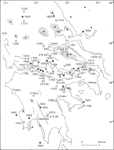
century AD amounts to just over eighty (Fig. 1). Seen by historical periods,
we may identify a comparatively acceptable level of reported activity during
the 5th century BC, literary sources providing information for twelve
earthquakes. While it is certain that many small earthquakes must be missing
from the record, we can reasonably assume that most of those of which details
survived were relatively important events. It is also reasonable to assume
that any major or damaging earthquakes in the vicinity of the larger urban
centres of the time should be mentioned.
After the 5th century BC, however, the number of earthquakes identified gives
way to a generally very low level in the Greco-Roman, Byzantine and Venetian
periods. This decline has to be seen in terms of inferior reporting of events
in sources lacking material of local origin rather than due to lack of seismic
activity. After the 14th century the situation gradually improves, but our
dependence on information from Venetian and Turkish sources gives the
distribution of earthquakes a bias in favour of coastal areas, while data
from places further inland continue to be almost totally lacking.
It is only after the 17th century that documents, such as consular
correspondence, Turkish unpublished material, the diaries of European travellers
and press reports, begin to preserve data that would otherwise have escaped
notice in more general works and provide information about seismic activity.
For this and earlier periods local, Greek sources are almost totally lacking.
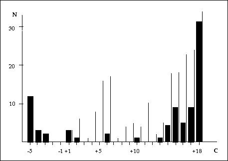
Fig. 2 shows the time distribution of the number of earthquakes per century
in the region shown in Fig. 1.

Fig. 1 - Distribution of earthquakes of Ms>6.0 in central Greece (updated from Ambraseys and Jackson, 1990).

Earthquakes in Athens
A typical example of the incomplete earthquake record of Greece is that for
the city of Athens.
The historical record of Athens appears to have been almost free of destructive
earthquakes. There is little in literary sources and no epigraphic material
referring to earthquakes in Athens (Robert, 1978). Earthquake damage known
to have occurred in the city during its 25-century long history has been
very infrequent, small, and chiefly due to relatively large earthquakes
originating either on land or offshore at some considerable distance from
the city.
427 BC
The earliest known earthquake to have caused some concern in Athens occurred
in the winter of 427 BC. During that period there were repeated shocks in
Athens, but also in Evia and Boeotia, particularly at Orchomenos. The passage
in Thucidides (Histories, iii, 87) that refers to these events clearly implies
that these shocks originated some distance away from Athens, perhaps from
the region just south of Atalanti, about 90 km from the city, where they
caused no damage.
426 BC
Archaeological evidence suggests that an earthquake in 426 BC was responsible
for the dislocation of the NE corner of the Parthenon, and for the displacement
of about one third of the east facade of the temple by about 2.5 cm (Korres,
1985). The shock of 427 BC was apparently a precursor of the large magnitude
earthquake that followed in the summer of 426 BC in the region between Atalanti
and Scarpheia. However, Athens, at an epicentral distance of about 140 km,
is not mentioned by Thucidides (Histories, III, 89), and by later writers
such as Demetrius of Callatis in Strabo (Geography, I, 3, 20), and Diodorus
(Library of History, XII, 59), who describe the destructive effects of this
shock (see also Bousquet and Pechoux, 1981). An earthquake of this magnitude
would certainly have been felt in Athens, but at such a large epicentral
distance its effects should not have been serious. The silence of historical
sources about damage to the Acropolis and to the city of Athens, as well
as to other towns as far as Opus, contrasts strangely with the interpretation
and dating of the damage of the Parthenon observed by Korres and Bouras (1983).
An earthquake sufficiently strong to cause damage to the solid structure
of the Parthenon should have been more damaging or even destructive in the
city of Athens, probably with casualties, and for this we have no evidence.
It is possible that the Parthenon was damaged much later, possibly in the
explosion of 1687, or alternatively, that its ruins were dislodged by earthquakes
after the 18th century. Destructive earthquake effects in Athens clearly
stretches the size of the 426 BC earthquake beyond the limits of the
possible.
420 BC
The second and last earthquake of the classical period reported from Athens
occurred in the summer of 420 BC (Thucidides, Histories, V, 45). The shock
is described as slight by Plutarch (Lives, Nic., 271), presumably originating
at some considerable distance from the city.
32 AD ca.
An earthquake in Athens is alluded to by Dionysius (Letters, 7, p. 303; p.
327) circa 32 AD. This was probably the result of a large earthquake in the
Sea of Marmara, or more likely, a "supernatural" event associated with the
Crucifixion.
2nd to 18th century
For the following 16 centuries we could find no information relating to
earthquakes in Athens. During this period the city gradually ceased to be
a centre of importance; it became remote and ultimately well removed from
the great centres of literature and culture.
1705 September 3
Evidence for earthquake damage in Athens about the turn of the eighteenth
century is found in a 4-page manuscript history of Athens (Ambraseys and
Finkel, 1992; 1993). The shock caused considerable damage to various structures
in the Acropolis as well in Athens, to buildings already weakened by the
siege of 1687 and subsequently abandoned. Of the buildings affected by the
earthquake in Athens, the church of St. Dionysius and the nearby residence
of the Metropolitan, neither of which is extant, were located at the north
foot of the rock of Areopagus. The cells of the monastery of Nikodimou must
have been located in the vicinity of the modern Russian church. The location
of the Vasiliki Ekklisia is not certain: perhaps it was located near the
Stadium. There is no evidence that the earthquake caused any loss of life
among the inhabitants and garrison of the Acropolis or serious damage in
the town itself: for example, that the Cathedral of Athens must have survived
the shock intact, since three days later it was safe enough to be used for
congregation.
There is no reason to suppose, however, that other towns were not affected
in this earthquake. It is possible that some of the damage reported in Turkish
unpublished documents from Negreponte at about the same time could have been
the result of the same earthquake.
Although some doubt must remain as to the actual date of the event, 3 September,
the year of the earthquake can now be fixed in 1705, and the epicentre of
the event located somewhere between Oropos and Plataeae, a location about
30 km distant from both Athens and Negreponte. Unfortunately, Venetian sources
for this region become scarce after the Carlowitz treaty in 1699, and no
information about this event so far has been found therein.
A shock reported from Zante in 1705, may well be a different event, belonging
to the aftershock sequence of the earthquake of November 1704 in the Ionian
islands.
However, the fact that as yet we have found no mention of an earthquake in
1705 in central Greece in the consular and Jesuit correspondence from towns
in the Morea and neighbouring regions (Egina, Corinto, Napoli di Romania,
Patrasso, Smyrna, Constantinople), as well as no mention in the European
press of the time, implies that perhaps the shock that affected Athens in
1705 was not felt very far and did not cause any great concern in nearby
towns - in other words, that the 1705 earthquake was not a large magnitude
event.
1785 June 13
Another earthquake was felt in Athens on 13 June 1785 (Old Style) (Burnias,
1892), but it is very unlikely that it caused any damage; a number of travellers
that passed through Athens shortly after that date do not mention any noticeable
effects. However, we know that this earthquake originated most probably from
the region of Oropos, 35 km N of Athens, where it caused considerable damage
that extended to the fortress of Egribos (Chalkis), to Oropos and to farms
in region of the Darbent of Sulesi.
19th century
With the advent of the 19th century, there is an obvious improvement in the
volume and quality of data, which becomes more complete as we approch the
20th century. This is largely due to the availability of additional published
sources of information. Archival material nevertheless continues to provide
much useful data. Thus, the number of earthquakes identified in Greece for
the 19th century amounts to over 1500. However, only very few caused concern
in Athens, chiefly relatively large, distant earthquakes, the more important
of which are the following.
1805 September (November) 17
On the night of 17 September a shock was felt in Athens as a result of which
"some blocks of the western tympanum (of the Parthenon) were thrown down"
(Dodwell, 1819). The context in which the event is recorded suggests the
17th, either of September or of November 1805. The shock caused no damage
in Athens and it is not mentioned in other sources. Sieberg (1932) says that
this earthquake was responsible for great damage in the town and this inaccurate
information is repeated by later writers. This was a small, probably local
shock that triggered the fall of pieces of marble from the Parthenon, loosened
by the dismantling operations of 1801-1803.
1837 March 18
An earthquake in the southern part of the Saronic Gulf near Hydra, of a probable
magnitude 6.4, caused great panic and some damage in Athens, 58 km away.
In the Agora, blocks of marble from the gable-end of the tetrakionion were
thrown down to the west (Schmidt, 1879).
1853 August 18
This earthquake had an estimated magnitude of 6.0, and affected the region
of Thiva, about 53 km from Athens. The shock caused considerable panic in
the city but no damage. We could fine no evidence for damage to historical
monuments in Athens.
1874 January 17
In the morning there was an earthquake in Athens (pop. 65,000). According
to Schmidt (1879), the shock caused the collapse of a part of the wall of
the Acropolis built by Odysseus Androutsos in 1822. However, the press in
Athens (Aeon, Ethnophylax, Alitheia, Eph. Syzitiseon) does not confirm Schmidt's
information. Otherwise, the shock was not felt by the majority of the inhabitants
of the city and it was not reported from other places. Galanopoulos (1956)
says that this was a damaging shock, which is clearly an exaggeration. Apparently
this was a small local earthquake and the collapse of the wall was due to
its vulnerability rather than the severity of the earthquake.
1889 January 22
At 6h 15m an earthquake caused some damage to the monastery of Daphni, causing
vertical cracks to open in the dome and walls of the church and in some of
the cells (Galanopoulos, 1953).
1894 April 20
The earthquake of 20 April, had a magnitude 6.4, and originated in the region
of Martino. In Athens (pop. 140,000), at an epicentral distance of 90 km,
a few old houses were thrown down and several buildings were fissured. A
block of marble fell from Adrian's Gate and the capital of an old column
in the Agora was thrown down.
1894 April 27
A few days later, a larger earthquake of magnitude 6.9 occurred at Atalanti,
100 km NW of Athens. In the city the shock caused great panic and some minor
damage, but no casualties. In the Acropolis a few existing cracks in the
eastern pediment of the Parthenon were enlarged by the shock and small blocks
of marble fell of the epistyle.
20th century
After 1900, the availability of documentary information continues to improve,
supplemented by instrumental data. During this century few earthquakes pass
unrecorded, generally only so far as minor events are concerned, only very
few of them being of any consequence in Athens. Of the many hundreds of shocks
felt in the city during this century, the following caused some concern or
damage to historical monuments.
1914 October 17
This earthquake occured between Thiva and Chalkis and had a magnitude 6.2.
In Athens, at an epicentral distance of 47 km, the shock caused panic; a
small number of dilapidated houses collapsed and a few buildings suffered
minor damage. There was no damage to the monuments on the Acropolis.
1928 April 22
This was a magnitude 6.3 earthquake near Corinth. In Athens, at an epicentral
distance of 77 km, the shock caused some panic and minor damage to a small
number of old houses. There is no evidence that it caused any concern to
those involved at the time with the restoration of Acropolis monuments.
1930 April 17
This 5.9 magnitude shock occurred on the SW coast of the Saronic Gulf, 59
km from Athens. In the city, 4 old houses collapsed, and few were cracked.
There is no indication that the shock caused any damage to historical monuments
in the city.
1938 July 20
The earthquake in Oropos, 37 km north of Athens, had a magnitude 6.1. It
was strongly felt in the city where it caused little panic, and insignificant
damage. We could find no information about damage to historical monuments
in Athens.
1965 July 6
This earthquake had a magnitude 6.4 and an offshore epicentre in the Gulf
of Corinth, 122 km from Athens. It was generally felt in the city where it
caused absolutely no damage.
1981 February 24
The main shock of the earthquake sequence in the Alkionides had a magnitude
6.7. In Athens (pop. 3,000,000) at an epicentral distance of 77 km, the main
shock and its strong aftershocks ruined about 500 houses and caused widespread
but minor damage to a number of public buildings. In archaeological museums
a number of exhibits were broken and the Parthenon sustained minor damage;
the SE, but chiefly the NE corner of the monument were displaced by a few
centimetres and some of the joints were caused to open up (Zambas, 1985).
Five hours later, there was a strong aftershock of magnitude 6.4, originating
from an epicentral distance of 60 km. This shock caused no further displacements
and had no effect on the opening of the joints, (Korres and Bouras, 1983).
Discussion
The general conclusion is that the long-term historical seismicity of central
Greece for the period before the 18th century is very imperfectly known.
The main factors seen to influence the completeness of data are the quality
of the contemporary literary record, the prevailing historical circumstances,
the geographical location of events and their magnitude. For this period,
local sources seem to be the only fund of macroseismic information for the
region, and in the absence of such sources our data is clearly incomplete.
Consequently, the apparent low earthquake hazard of a number of regions shown
on modern seismic maps of central Greece, such as the Gulf of Argos, the
Evrotas-Taygetos graben, northern Evia and Parnassos, may not be genuine,
and it may reflect partly the lack of long-term observations. The only conclusion
that we can draw from this re-evaluation is that there is no historical or
instrumental evidence, so far, that any of the earthquakes identified on
land have exceeded magnitude Ms 7.0 in size.
Conclusions
Our studies bring out a number of points that should be taken into consideration
when historical events are used in earthquake hazard assessment.
The vulnerability of modern man-made structures differs in many respects
from that of old ones. Historical monuments are sensitive to differential
settlements and their lateral stability is almost exclusively dependant on
frictional resistance. To judge the destructiveness of an historical earthquake
from 20th century case histories can be seriously misleading.
We should not, as we consistently have done, presume that the orderly or
disorderly distribution of masonry pieces always implies earthquake effects
and presume that an earthquake, many tens or hundreds of miles from the site,
however well attested in the sources, necessarily caused the damage.
Great care must be taken to establish the simultaneity of the destructive
effects of early earthquakes at places located large distances apart. Quite
often the amalgamation of the effects of two or more different historical
events stretches the size of the earthquake beyond the limits of the possible,
and leads to speculation and to the development of "catastrophe" theories.
The long-term seismicity of central Greece is clearly different from that
of neighbouring Anatolia in that either (a) no earthquakes of magnitude greater
than 7.0 occur, or (b) 500 years is not long enough to reveal such events
in central Greece, whereas 100 years is more than adequate in Anatolia and
in other parts of the Middle E