
EC project "Review of Historical Seismicity
in Europe" (RHISE) 1989-1993

|
[Deliverables and queries] [Presentation] [Homepage] |
Seismic background of the area
Based on neotectonic and seismological criteria,
Drakopoulos and Makropoulos (1983) divided Greece into thirteen seismic origin
zones. The Ionian Islands belong to the Hellenic trench subduction zone,
which commences from these islands and, through the southern part of Crete,
trends northeast, with maximum expected magnitude 7.5 and mainly shallow
foci. Focal mechanisms (Drakopoulos and Delibasis, 1982) and geological
information have shown that this region is affected by compressional
stresses.
The results for the most probable maximum magnitude
in the next 100 years show that the Ionian Islands belong to the high shallow
seismicity areas of Greece. In particular the island of Cephalonia has a
permanent high level of seismicity and has experienced earthquakes of magnitude
greater or equal to 6.0 approximately every 20 years (Makropoulos and Burton,
1985). The occurrence frequency of large earthquakes is at least one with
magnitude in the range of 5.5 - 6.0 every 10 years.
The macroseismic information from the 20th century
earthquakes shows that the shallow foci in the area (average depths around
10 km) indicate its capability for high degree of intensities and elliptical
to strongly elliptical shapes of isoseismals, with major axes mainly in the
NW-SE direction, parallel to the coastline and the Hellenic trench.
The major earthquakes of the area in the last
85 years are grouped in three epicentral areas: northern Leukada (4 events);
southern Leukada, northern Cefalonia and Ithaca (7 events); central and southern
Cefalonia (4 events). They were strongly felt in the N, E and SE, i.e. in
Epirus, Karditsa, Aitolia-Acarnania (Naupaktos, Mesolongion) and eastern
Peloponnese (Patras, Rion). The most recent earthquakes in Leukada on November
29 and December 1, 1994 had magnitudes 5.3 and 5.2 respectively, and preliminary
reports on the damage assign intensity VII-VIII in the village of Kalamitsi
and VI-VII in Karia and Exanthia, in the western part of the island, i.e.
a rather concentrated felt area.
The area has repeatedly experienced intensities
of the order of X. A series of strong historical earthquakes have been reported
from the area since 1469 continuing in the 20th century (28 major historical
earthquakes are reported for Leukada and Cephalonia).
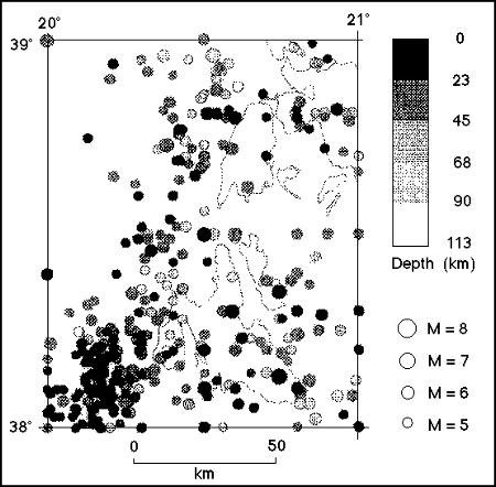
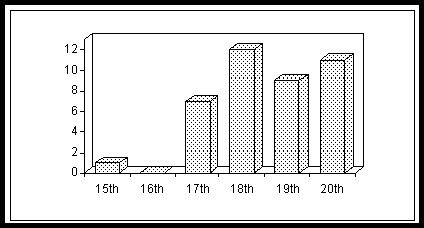
Tab. 1 contains the historical earthquakes of
the studied area up to1885 (Papazachos and Papazachos, 1989), while Fig.
1 shows the spatial distribution of the 20th century earthquakes with magnitude
M > 5.5 (Makropoulos et al., 1989). Fig. 2 summarizes the number of strong
earthquakes of the area per century since 1400.
| N | Date | Lat N | Lon E |
|
|
Region affected |
| 1 | 1469 Spring | 38.4 | 20.5 |
|
|
Cephalonia (Argostoli) |
| 2 | 1612 May 26 | 38.8 | 20.8 |
|
|
Leukada |
| 3 | 1613 Oct. 12 | 38.8 | 20.8 |
|
|
Leukada |
| 4 | 1625 June 28 | 38.7 | 20.7 |
|
|
Leukada |
| 5 | 1630 July 2 | 38.8 | 20.8 |
|
|
Leukada |
| 6 | 1636 Sept. 30 | 38.1 | 20.6 |
|
|
Cephalonia (Lixouri) |
| 7 | 1658 Aug. 24 | 38.3 | 20.5 |
|
|
Cephalonia |
| 8 | 1668 | 38.4 | 20.4 |
|
|
Cephalonia |
| 9 | 1704 Nov. 22 | 38.7 | 20.7 |
|
|
Leukada |
| 10 | 1714 July 27 | 38.2 | 20.5 |
|
|
Cephalonia |
| 11 | 1722 June 5 | 38.7 | 20.5 |
|
|
Leukada (Athani) |
| 12 | 1723 Feb. 22 | 38.6 | 20.7 |
|
|
Leukada |
| 13 | 1736 | 38 | 20.5 |
|
|
Cephalonia |
| 14 | 1741 June 23 | 38 1/2 | 20 1/2 |
|
|
Leukada |
| 15 | 1759 June 14 | 38.3 | 20.4 |
|
|
Cephalonia |
| 16 | 1766 July 24 | 38.1 | 20.4 |
|
|
Cephalonia |
| 17 | 1767 July 22 | 38.2 | 20.3 |
|
|
Cephalonia (Lixouri) |
| 18 | 1769 Oct 12 | 38.9 | 20.6 |
|
|
Leukada |
| 19 | 1783 Mar. 23 | 38.6 | 20.5 |
|
|
Leukada (Athani) |
| 20 | 1783 June 7 | 38 3/4 | 20 3/4 |
|
|
Leukada (Vavkeri) |
| 21 | 1815 | 38.7 | 20.7 |
|
|
Leukada |
| 22 | 1820 Mar. 17 | 38.8 | 20.6 |
|
|
Leukada |
| 23 | 1825 Jan. 19 | 38.7 | 20.6 |
|
|
Leukada |
| 24 | 1834 July 5 | 38 | 21 |
|
|
Cephalonia |
| 25 | 1862 Mar. 14 | 384. | 20.5 |
|
|
Cephalonia (Argostoli) |
| 26 | 1867 Feb. 4 | 38.2 | 20.4 |
|
|
Cephalonia (Paliki) |
| 27 | 1869 Dec. 28 | 38.8 | 20.7 |
|
|
Leukada |
| 28 | 1885 Dec. 14 | 38 3/4 | 20 3/4 |
|
|
Leukada (Englouvi) |
Macroseismic intensity assessment
The 1767 Cephalonia and the 1769 Leukada earthquakes
are listed by Papazachos and Papazachos (1989) with the following
parameters:
|
|
|
lat long |
|
|
|
| 1767 07 22 |
|
38.20 N 20.30 E |
|
|
|
| 1769 10 12 |
|
38.90 N 20.60 E |
|
|
|
The new evidence concerning the two earthquakes
and the affected areas (Tsiknakis et al., 1990, 1993; Albini and Daltri,
1991; Albini, 1991) led to an
exploitation of the information
on the effects of the two earthquakes, expressed in terms of macroseismic
intensity distribution in the whole affected area.
Characteristics of the buildings
For intensity assessment, the information on
the buildings of the time generally allows their classification into low
resistance classes (A or B), as described in the macroseismic scale modified
MSK 64 currently used in Greece. However, in the case of the studied earthquakes,
this classification must be performed with special care, taking into
consideration the fact that during the period 1700-1766 at least seven strong
earthquakes are documented as having caused serious damage in both Cephalonia
and Leukada.
Leukada.
In the 18th century the houses in
the villages were built by masonry, while in the main town both masonry and
wooden frame houses can be found. Prior to the 1825 earthquake the houses
in Leukada had a wooden frame (casa baracata), a method applied by
the Venetians. The antiseismic design was introduced later by the English.
However this system was applied only in the houses of Santa Maura, while
in the villages the traditional masonry structure was applied. These structures,
in order to withstand earthquakes, had thick walls and small openings.
Cephalonia.
Around 1780 the misery in the town
of Argostoli is described as "a pile of deserted huts", a town with badly
built houses, most of which were deserted because of the earthquakes. In
Lixouri the damage from the earthquakes was evident in that most houses had
nearly collapsed. The streets in Lixouri were full of ruins and it was difficult
to walk in the town.
Cephalonia earthquake, 1767 July
22
The research on available sources showed that
the time of the mainshock occurrence was "13 hours" (expressed in "Italian
hours"), and six aftershocks were reported from almost all the Ionian
Islands.
The earthquake struck most main towns and villages
of Cephalonia. In Lixouri many deaths were reported and almost the whole
town suffered great damage. Great damage was also reported from Lixouri fortress
and the surrounding villages (people evacuated their houses). In the town
of Argostoli and in the fortress very few houses were left inhabitable. Damage
was also observed in the walls of the fortress. Further to the north, in
the Paliki peninsula, in the town and fortess of Assos strong shaking was
reported, rocks fell, houses were completely destroyed or evacuated. At least
one person died and many were wounded. Piles of stones were seen everywere.
The houses and churches in the fortress of the town were also destroyed.
The above information corresponds to intensity X (MSK 64, modified) in these
areas.
The shock struck also the island of Zante, south
of Cephalonia. Detailed reports refer to the damage in the main town of Zante,
in the eastern part of the island. Despite the great damage, some houses
remained untouched. As the financial aid requested from Zante to the Venetian
government was not substantial, it is assumed that the above damage was observed
in less houses than in Cephalonia. An intensity IX is therefore assigned
for Zante.
In Leukada and Corfu there is little information
on effects from this earthquake (intensity IV-V?). In addition, effects were
reported from the towns of Amphilokhia and Patras, in western Greece. The
shock was also felt as far as Meteora (central Greece), as reported by one
monastery chronicle (N. Ambraseys, personal communication).
All the above information leads to the conclusion
that this earthquake was particularly strong, similar to others that have
occurred in Cephalonia also in the 20th century. The ample information on
heavy damage distributed around the gulf of Argostoli shows that the meizoseismal
areacovers this part of the island. However, the epicentre of the earthquake
could just as well be located nearer to the island, so as to justify the
damage in central and eastern Zante.
Almost all the descriptions refer to aftershocks,
some of which continued until October of the same year.
Leukada earthquake, 1769 October
12
Detailed information on the distribution of
damage was derived mainly from the correspondence between the Venetian ruler
Andrea Donà and the Venetian Senate (Daltri e Albini, 1991; Kouskouna
et al., 1993).
The earthquake occurred on 12 October 1769,
at 19 hours ("Italian hours") and it had at least three aftershocks on 13
and 14 October 1769, felt only in Leukada. The casualties were seven dead
and many injured.
The mainshock caused serious damage to the town
of Amaxiki, the settlement of Perivolaki (one mile away from Amaxiki), the
fortress of Santa Maura and the area of Alikes, in the NE part of the island,
whilst the villages of the island suffered minor damage.
In the town of Amaxiki 10 churches and 497 houses
and shops collapsed completely, and another 3 churches and 329 houses and
shops were seriously damaged. The total number (826) of houses and shops
in Amaxiki were damaged by the earthquake. Taking into consideration the
population of the town (6,000) this figure seems reasonable. Therefore most
of the churches (77%), houses and shops (60%) collapsed completely, and the
rest suffered serious damage. These figures correspond to intensity IX-X
in Amaxiki.
In the fortress damage was observed in the walls,
the eastern part of which almost collapsed, together with one arc of the
bridge connecting the fortress to Amaxiki. From the buildings inside the
fortress, 5 houses collapsed, while the hospital, the monastery, two churches
and 5 houses suffered serious to moderate damage, i.e. intensity VIII is
assessed for this part of the island.
In Old and New Alikes, SE of Amaxiki, displacement
of the salt pans and serious damage of the walls and roofs of the depots
was reported, and bricks were strewn everywhere (intensity VIII).
In the villages of Leukada and some villages
of Cephalonia the earthquake was felt strongly (intensity IV-V). The earthquake
was also felt in Ithaki, Zante, Corfu, Rio, Antrirrio and Naupaktos, which
leads to an intensity not higher than III.
Seismological interpretation
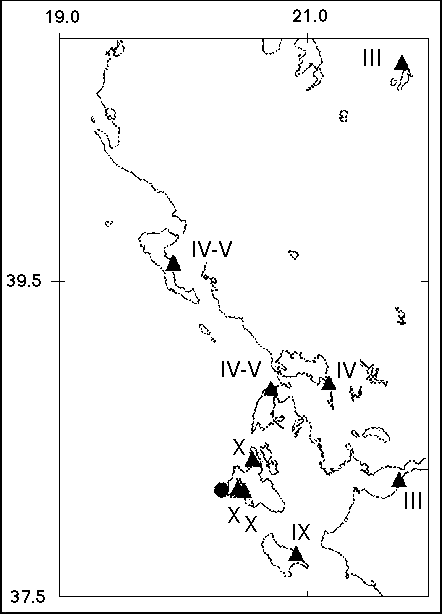
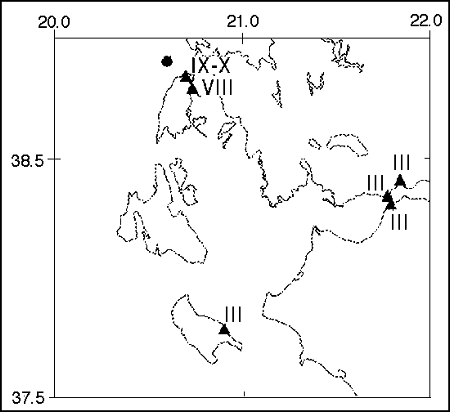
The intensities of the two studied earthquakes
assessed in the previous paragraph and their distribution are presented in
Figs. 3 and 4. In what follows, an attempt is made to correlate this distribution
to the distribution of macroseismic effects of other earthquakes of the same
area.
With regard to the Cephalonia earthquake of
1767, the large number of sources and their thorough study showed that the
ample macroseismic information from the island of Cephalonia, the other Ionian
Islands and some parts of Greece implies that the magnitude of this event
was larger than the Leukada earthquake.
The effects of this earthquake in the meizoseismal
area are in agreement with the previously assumed intensity. The effects
in Amfilokhia and Patras (intensity IV) and the reports from Meteora (intensity
III) are in agreement with the perceptibility radii of this century's earthquakes
of the same order of magnitude and epicentral intensity. According to the
damage pattern of this earthquake, its macroseismic epicentre is located
in central-southern Cephalonia.
The high intensity observed from the 1769 earthquake
specifically in the town of Amaxiki, i.e. the small epicentral area, might
be attributed to the bad condition of the houses and the unfavorable soil
conditions, on which these houses were built. This might also lead to a very
local earthquake (epicentre in the northern part of the Leukada island area,
near to the town of Amaxiki). In any case, it would not be recommended to
assess a
magnitude from relationships of the form (M=f(I)),
since this degree of intensity is observed only at one site.
The detailed study of the 1769 Leukada earthquake
gave firm ground to a preliminary hypothesis that the magnitude of the earthquake
has been overestimated. It seems that this event had a smaller magnitude
than the one in 1767 and a shallow depth (less than 10 km), resulting in
localized macroseismic effects and high attenuation of intensities with
increasing distance. In fact, if the 1769 earthquake had a magnitude M =
6.8, one would expect some damage reported from NE Peloponnese and
Aitolia-Acarnania from the Leukada event, instead of simply being felt there.
In addition, all the earthquakes of this order of magnitude from the area
have caused damage at a distance of 120-150 km (Kouskouna et al., 1994),
a fact which did not occur in the case of the Leukada event.
The fact that the area has suffered continuously
the effects of several earthquakes in a small period of time (Fig. 2) gives
credibility to the assumption that a great deal of the damage caused by the
two studied earthquakes in buildings in both islands and mainly Leukada is
cumulative.
Discussion and conclusions
The seismological analysis of the two historical
Ionian Islands earthquakes of 1767 and 1769 revealed interesting information
that should not be neglected in seismic hazard studies.
Apart from the purely historical interest, the
study of historical earthquakes results in a better estimation of the return
periods of major earthquakes, which results from a more accurate and realistic
maximum intensity and hence macroseismic magnitude assessment. The instrumental
data, although often useful for calibration, are not sufficient for the
evaluation of large return periods. A striking example for the area of Greece
is the Atalanti 1894 earthquakes, which were not repeated in the 20th century,
and therefore their return period, if based only on instrumental data, is
unknown.
The distribution of the effects of the 1767
Cephalonia earthquake is similar to these earthquakes with the same epicentral
area (central-southern Cephalonia) in the 20th century. Thus, it is assumed
that this event had a magnitude of about 7 1/4, caused maximum intensity
X and had a shallow depth.
The Leukada earthquake of 1769 most probably
caused a maximum intensity IX in a much smaller area than the previous event.
The damage was localized in the northern part of the island. This fact, together
with the observation that the earthquake did not cause serious damage to
the other Ionian Islands, leads to the conclusion that its magnitude must
have been much smaller than the magnitude of the Cephalonia event. In other
words, the empirical formula that relates the maximum intensity with macroseismic
magnitude does not apply completely in this case.
In conclusion it is stressed that, when dealing
with historical earthquakes, their magnitude should be assumed not only from
their maximum intensity but also from their damage pattern.
Acknowledgements
We wish to thank Paola Albini and Kostas Tsiknakis
for their participation and helpful discussions on the historical research.
References
Albini, P. and Daltri, A., 1991. The Serenissima Republic
of Venice and the Earthquakes. In: J. Kozak (Editor), Proc. 3rd ESC Workshop
on "Historical Earthquakes in Europe", Liblice by Prague, 4-6 April 1990,
pp. 98-114.
Albini, P., 1991. Datazione e prima stima degli effetti dei
terremoti nelle Isole Ionie nell'anno 1767 da documenti veneziani. In: P.
Albini e M.S. Barbano (Editors), GNDT, Atti del Convegno, Pisa, 25-27 giugno
1990, 2, Macrosismica, pp. 111-124.
Daltri, A. e Albini, P., 1991. L'Archivio di Stato di Venezia:
studio sulla potenzialità della documentazione ivi depositata ai fini
delle ricerche sui terremoti europei di interesse per il Progetto CEE "RHISE".
Progress Report, Milano.
Drakopoulos, J. and Delibasis, N., 1982. The focal mechanism
of earthquakes in the major area of Greece for the period 1947-1981. Univ.
of Athens Seism. Lab. Publ. 2, 185 pp.
Drakopoulos, J. and Makropoulos, K.C., 1983. Seismicity and
seismic hazard analysis studies in the area of Greece. Univ. Athens Seism.
Lab. Int. Publ. 1, 184 pp.
Kouskouna, V., Makropoulos, K.C. and Tsiknakis , K., 1993.
Contribution of historical information to a realistic seismicity and hazard
assessment of an area. The Ionian islands earthquakes of 1767 and 1769:
historical investigation. In: M. Stucchi (Editor), Materials of the CEC project
Review of Historical Seismicity in Europe, 1, Milano, pp. 195-206.
Kouskouna, V., Papanikolaou, D. and Papoulia, J., 1994. Strain
anisotropy and non-uniform macroseismic intensity distribution. ESC XXIV
Gen. Ass., Athens, September 19-24, 1994, in press.
Makropoulos, K. and Burton, P.W., 1985. Seismic Hazard in
Greece. I. Magnitude recurrence. Tectonophysics, 117: 205-257.
Makropoulos, K.C., J.K. Drakopoulos and J.B. Latousakis,
1989. A revised and extended earthquake catalogue for Greece since 1900.
Geophys. J. Int., 98: 391-394.
Papazachos, B. and Papazachos, K., 1989. The earthquakes
of Greece. Ziti Publ., Thessaloniki, 356 pp.
Shebalin, N.V., Karnik, V. and Hadzievski, D. (Editors),
1974. Catalogue of earthquakes of the Balkan region. Parts I-III. UNDP/UNESCO
Survey of the seismicity of the Balkan Region, Parts I+II, 600 p., Part III,
Atlas.
Tsiknakis, K., Makropoulos, K.C. and Kouskouna, V., 1992.
Review of the Ionian Islands historical seismicity. The Leukada earthquake
of October 1st 1769. In: A. Roca and D. Mayer-Rosa (Editors), Proc. XXII
ESC General Assembly and activity report 1988-1990, Barcelona, 17-22 September
1990, I, pp. 311-316.
[Top]
[Vol.1]
[Vol.2]
[Deliverables and queries]
[Presentation]
[Homepage]