EC project "Review of Historical Seismicity
in Europe" (RHISE) 1989-1993
|
|
[Deliverables and queries] [Presentation] [Homepage] |
Since the Seventies most of the earthquakes originating in the Lower Rhine-Meuse
source zone have been discussed by the author for various reasons, ultimately
in the frame of the CEC Project "Review of Historical Seismicity in Europe"
(Stucchi, 1993). While the author's other specific contributions to these
"Materials ..." strictly respect the original time-window, this paper
deals with an earlier event, that of April 4th, 1640. Several major earthquakes
have been revised in a systematic way, with sometimes drastic results for
the location of the epicentres and/or the far-field, for instance for 1504
and 1692 quakes (Vogt, 1984a), while the 1640 event has only been dealt with
incidentally, without any specific research, with, nevertheless, some results
of interest. Once more doubts arise about the way it has been handled by
ancient and modern catalogues.
First, let's consider the statements by some catalogues. While Perrey (1845)
gives a correct second-hand overall view, although unusable for the needs
of modern historical seismology, Lemoine's comments (1912) are a disaster,
underlining an alleged similarity with the 1580 (North Sea!) earthquake,
stressing the Anvers-Namur-Cambrai area with these words: "...
séisme essentiellement localisé au Nord de la zone
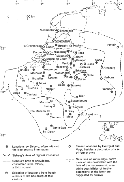
houillère ...". A clear view (Fig. 1) is given by Sieberg
(1940). Using information from Düren and Köln he proposes, with
some caution, an epicentre in the well-known Roer-valley source zone, without,
however, giving an epicentral intensity for this 'destructive earthquake'.
Strangely enough modest intensities, V or so, are given for Aachen and Erkelenz,
nearby.
The far-field extends as far as to Utrecht, Frankfurt, Metz, Cambrai. However,
no further intensities are given. Whatsoever the degrees proposed at Aachen
and Erkelenz are hardly compatible, in terms of decrease of intensities as
well with the suggested epicentre as with this macroseismic area, a logical
problem not dealt with by later catalogues. J.P. Rothé's unpublished
catalogue of the historical seismicity of France repeats mostly the former
ones, adding some information from Douxami's classical paper on the seismicity
of Northern France (Douxami, 1912). Van Gils' Belgian catalogue (Van Gils
et al., 1978) follows Sieberg, but he is the first, at my knowledge, to propose
an epicentral intensity: VII-VIII.
Unfortunately, reproducing Sieberg's qualitative sketch, he adds intensities
V at Düren and IV in Köln, clearly a drawing error but not without
consequences. A recent German listing (Leydecker, 1986) adopts the same epicentre
and the same epicentral intensity (VII-VIII), with a macroseismic radius
of 150 km.
Former catalogues were used uncritically by the Dutch catalogue (Houtgast,
1991). Strangely enough, Sieberg's sketch is reproduced with Van Gils' drawing
errors. Although some information is added (damage at Maastricht and Boxmeer)
this sketch has not been amended, without any further discussion. The intensity
II-III attributed to Sieberg's outline of the far-field is not acceptable.
Clearly, Sieberg gives an outline of his knowledge of the far-field. Otherwise
he would have proposed himself such an intensity. Further, a magnitude, 5
1/4 (sic), is ventured.
While my own casual reading neglected the hitherto proposed epicentral area,
some remarks are nevertheless made about certain or alleged damage. For
Köln a precise information is given by a later source: "... es
ein Stück von der Stadtpforten übern Haufen geworfen
...", this damage being, however, an extreme case for we read further:
"... sonst ... wenig Schaden getan
"(Unglücks-Chronica, 1693). Nevertheless Sieberg writes:
"... zu Köln viele Schornsteine stürzten". Clearly
this information is inspired by a local chronicle from Köln (Eckertz,
1876), writing: "... sind viele Schornsteine herunter gefallen".
However the context of its description of the earthquake does not exclude
the possibility of a statement of a more general kind. Unfortunately the
case of Düren, nearest to the proposed classical epicentre, escaped
my own reading of sources. Anyway, Sieberg states: "... In Düren
wurden Mauern gespalten", an information not given by Lersch's famous
unpublished catalogue used to a wide extent by Sieberg's catalogue (1). Doubts
arise also with Maastricht where damage is stated by the Dutch catalogue
(Houtgast, 1991). While one source tells indeed about important damage, possibly
not locally, but in a more general way (2), another limits itself to the
fright produced by a strong shock (3). Both sources should be considered
critically, beside, of course, other ones. The same problem arises with Boxmeer.
Possibly it is the mention of important damage of a more general kind (Thiery,
1983). Probably it is also the case with Annales Drenthiae (Picardt,
1660). After a description of the wide area of the earthquake we read:
"... In sommige plaetsen waren groote onderaerdtse regenbacken
van malkanderen gescheurt, huysen geborsten ... ". Unfortunately
these places are not named. Clearly further research is needed for a better
appraisal of the epicentre and the epicentral intensity.
Whatsoever, a set of testimonies not so distant from the presumed epicentre
describes strong shocks without any information on damage. For Erkelenz,
where Sieberg proposes a degree IV-V we read: "... terribilis terrae
motus hic et ubique fuit" (Eckertz, 1864). Several testimonies from
Liège stress the fright, with this example: "... tremblement
de terre si terrible qu'un chacun pensait mourir" (4).
Besides a particular problem arises in the region of Monschau, where Sieberg
describes a complex sequence in 1641, at the same time, with a panic, people
fleeing houses. Strangely enough the comments by Relationis
Historicae (1641) insist on the fact that such events seldom occur
in this region: "... dergleichen prodigia ... solcher Orten wenig
verspürt worden und selten gesehen". But what about the 1640 earthquake,
one year before? Another question mark ...
Let's turn to testimonies from more distant locations, in several directions,
until the limit of knowledge. To the North/North-West, a late, summary testimony
comes from Duisburg: "... ein schreckliches Erdbeben" (Borheck,
1800). At Kempen, the earthquake is described with some detail, stressing
once more the panic (Wilmius, 1985). While nearby Lobberich is listed by
Sieberg, clearly using Lersch's catalogue (5), the local source, given by
the latter, is however rather general, once more: "... fuit per
inferiorem et superiorem Germaniae concussio terrae tam vehemens ut castra,
oppida, turres commoveant" (6). A priest from Rees, where the earthquake
is probably strongly felt, devotes an Oratio to it (Stalen, 1640).
At Maaseyck an 85 year old man used in 1687 as a chronological reference
an earthquake 57 or 58 years before (Thijskens, 1992). Considering the
possibility of some error, 57 instead of 47, we do not exclude that this
testimony refers in fact to the 1640 earthquake. From Nijmegen, a lengthy
letter comments the event, without precision (Theatrum Europaeum). At Utrecht,
this uncommon earthquake, "res in hisce locis insolita", is noted
concisely (Van Campen, 1940). Here we reach the Northern limit of Sieberg's
sketch of the far-field while Houtgast adds Amsterdam. Indeed a source from
Utrecht mentions: "... terrae motus factus est hic et Amsterodami
vicinisque locis" (Van Campen, 1940). However the far-field extends further
North, over the degree II-III line of modern catalogues. So the earthquake's
effects, slight indeed, are precisely described at Zutphen with, for instance,
the rattling of musical instruments (Van V., 1933). From a rather ambiguous
source it cannot be excluded that it is felt by a minority of people at Enkhuizen
(Anonymous, n.d.). Even from Medenblik we hear: "In het jaar 1640, den
vierden April, isser allhier een ardtbevingh gewest ..." without,
however, a source being given, so that a checking is needed (Belonje et al.,
1943). Inside the catalogue's North-western part of the macroseismic area,
information is of course more numerous than listed hitherto. So the earthquake
is reported from Leyden (7), from the Hague (8), from Dordrecht: "...
was'er binnen Dordrecht een groote aardbevinge" (Balen, 1677).
Westwards we already mentioned Liège. Further Sieberg lists a lot
of locations without, however, precise information. At Brussels, most people
are frightened: "... la plupart des habitants en furent grandement
effrayés" (Le Boucq, 1858). At Mechelen, the famous Van Helmont
describes a strong shock: "...Mechlinia ... insigniter tremuit
..." (Coninck, 1926). A similar information comes from Bergen-op-Zoom:
"... il s'est fait à Bergozzom et ès quartiers
d'altentour en temps calme un grand tremblement de terre ..."
(Nouvelles ..., 1640). However contemporaneous sources insist on Antwerpen.
So the same Nouvelles write: "A Anvers et plusieurs autres places
il fut plus grand et plus épouvantable" (than at Bergen-op-Zoom).
Actually the sequence is described there in great detail and its effects
in a somewhat catastrophic way, at first glance: "... viel Gebäu
aus ihren Fundamenten verrückt und die Menschen mitsamt der Betten in
die Höhe gehoben wurden ..." (Relationis ..., 1640).
Our first comment had been the following: "Without careful discussion and
checking, such words could too easily lead to an overestimation of intensities".
Since, we got hold of another information, astonishing at first glance,
concerning damage suffered by the fort of Lillo, downwards on the left bank
of the Schelde: " ... le fort de Lilo a été presque
ruiné, une grande partie de ses remparts en ayant été
renversés ..." (Gazette de France, 1640b). So a deeper-digging
discussion is needed. At Mons, a strong shock, fort impétueux,
is recorded as well, with a hint at slight damage: "... le désorder
... se répara ... à peu de frais" (Boussu, 1725). Further
West, ancient and modern catalogues only know Cambrai, probably repeating
Perrey, without further research, ignoring Douxami's classical paper (Douxami,
1912). Actually, the earthquake is reported not only from Cambrai, but also
from Lille, Douai, Orchies (9) and Arras where the fright provokes, it seems,
the death of the night-watcher of the belfry, three days later (10). Once
more we hear of damage: "... un tremblement de terre qui causa
bien du dommage", but probably in a general way, easily misleading (11).
Despite the II-III isoseismal of modern catalogues, we don't know the limit
of the macroseismic area in this direction.
The macroseismic area extends far to the South in the Champagne, where Sieberg's
sketch is devoid of any information. This 'gap' is filled by two easily available
papers, first by Venderesse (Ardennes department) and Sainte-Menehould (Villette,
1905), secondly by Mouzon, Jamets (Ardennes department), Stenay, Clermont-en
Argonne (Meuse Department) and even Bar-le-Duc and Saint-Dizier, thanks to
the Gazette de France (1641; see also Douxami, 1912). So a harmonious
view is achieved, far South of the catalogues concave II-III isoseismal.
Southwards, the catalogues' II-III isoseismal is protruding into Lorraine,
with Luxembourg, Thionville and Metz, thanks to easily available sources
(for example Peters, 1898). Some more sources and locations should however
be added. So a Verdun chronicle writes that bells were moved in Lorraine:
"... Il fut si grand qu'il fit tinter les cloches en divers
lieux" (Tribout, 1933). A precise testimony from Longeville abbey, near
Saint-Avold, slightly extends the macroseismic area Eastwards: "...
estant à notre église, nos chaises du choeur ... en furent
secoussées, assez légèrement néanmoins" (Bigot,
1869). While intensities are generally low, a case of damage is known from
Saint-Pierremont abbey, near Briey: "... se fit un grand tremblemnt
de terre ... des pierres des murailles de dessus la chambre où
j'étais tombérent, ce qui me donna de l'épouvante"
(Rogié and Martin, 1904-05).
Eastwards, information is lacking in a wide area between Lorraine and the
region of Frankfurt. Sieberg's sketch also shows a 'gap' between the latter
and Westphalia. It is filled by one testimony, from Herborn: "...
wurden alle Gebäude nebst dem Schloss heftig erschüttert"
(Steubing, 1792). Unfortunately, Herborn is situated right on the II-III
isoseismal of the catalogues, once more concave. If we consider an intensity
of IV or so, the limit of the macroseismic area is reported at a fair distance
to the East. A similar problem arises North-eastwards. While a strong shock
is felt at Essen (Kirchner, 1952), Sieberg considers apart Unna, drawing
an enclave of higher intensity, strangely given afterwards a degree IV only.
However he has some doubts: "Angeblich sollen auch zu Unna in Westfalen
«viele Häuser verdorben» sein", an information coming
from a history of the province, probably via Lersch: "... wurden
durch ein ungewöhnlich Erdbeben viele Häuser in der Stadt verdorben,
doch kein Mensch dabei beschädigt " (Steinen, 1755). This
statement could not been checked until now. Actually, we also hear about
a strong shock at Arnsberg where all houses are shaken (Hüser, 1820
?), extending once more the macroseismic area. An information from Antwerpen
states that the earthquake was felt as far as the river Weser: "Notre
tremblement de terre s'étendit depuis ici ... jusques sur la Weser
..." (Gazette de France, 1640b). Actually, a more general statement comes
from the region of Rinteln: "Anno 1640 sind in der Gegend Rinteln etliche
Erdbeben gewesen ..." (Zeiller, 1655).
So the far-field is now better known than the epicentral area, thanks to
a wealth of forgotten or recently unearthed testimonies. A part of Sieberg's
limit of knowledge, with its concavities, later interpreted as an isoseismal,
is replaced by a more harmonious line. While this line could be partly near
the limit of the macroseismic area, possibly in Champagne, arrows should
be added elsewhere, mostly in Hessen and in the Netherlands, to suggest a
further extension of the macroseismic area.
Despite these explanations, a reader of the manuscript has been "astonished
that the nicely shaped cross-like pattern of the II-III isoseismal did not
provoke the author to speculate on the location and direction of the fault
along which the seismogenic slip occurred...". In fact, such a straightforward
use of a vague cross-like pattern, probably reflecting a state of knowledge,
would easily appear as a pseudo-objective undertaking.
Beside the hour, catalogues do not give any information on the characteristics
of the earthquakes, thus limiting possibilities of a more elaborate view
of its macroseismic features and of a genuine seismological interpretation,
with the help of a comparison with later, better known events. Luckily, the
sources forward a mosaic of such information, a sample of which is given
here.
All catalogues repeat the same hour: 3 1/4. The sources however give a range
between 1 1/2 and towards 4, the most frequent being between 3 and 4, of
course repeated from one to another. 1 1/2 appears only once at Kempen (Wilmius,
1985); as well as 2, at Brussels (Le Boucq, 1858) and between 2 and 3, at
Dordrecht (Balen, 1677). Towards 3, 3 or shortly after 3 is well represented,
at Essen (Kirchner, 1952), Maastricht (see note 3), Utrecht (Van Campen,
1940), Lille (see note 10) and, from sources not yet quoted, Liège
(Simenon, 1910) and Brugge (Curtis, 1765). Precisely 3 1/4 appears seldom,
at Leiden (see note 7) and Longueville abbey (Bigot, 1869). 3 3/4 is given
at Zutphen (Van V., 1933). The formula 'between 3 and 4' is the most common,
as well in Köln (Eckertz, 1876) as in Bergen-op-Zoom (Nouvelles ...,
1640). Towards 4 or 4 is given in Erkelenz (Eckertz, 1864), Duisburg (Borheck,
1800), Nijmegen (Theatrum Europaeum) with a special importance as a nombre
fatal for a numerological venture at Liège (Stiennon, 1990). On
the whole, these indications are coherent.
However it is not easy to appreciate the duration of the earthquake. Actually
indications are varying between a very short duration and a quarter of an
hour. Sometimes prayers are used to measure it, for example a Pater
and an Ave Maria at Boxmeer (Thiery, 1983), a "Pater ... ein ganz
Vaterunser lang", at Köln (Eckertz, 1876). In fact, such indications
may apply either to a sequence or only to the main shock. Some sources list
three shocks, for instance at Brussels, during nearly a quarter of an hour:
"... trois secousses et avec grand bruit ..." (Gazette
de France, 1640a). The most precise information concerning this sequence
comes from Antwerpen. A foreshock is clearly defined: "... anfangs
... nur ein wenig". It is followed, it seems, by two violent shocks,
the second being the strongest: "Der letzte Sturm ... war der allerheftigste
also, dass die ganze Stadt davon zitterte" (Relationis ..., 1640). It
should be stressed that such a description is not available for the presumed
epicentral area, although the problem of the sequence in the Monschau region
should not be forgotten.
Of course, noises are described, for instance at Maastricht: "...
wiert een gedruys in de locht gehoort ..." (see note 3) and
Liège: "... agitatione cum mugitu" (Simenon, 1910).
However only one information has been found on the direction, from Mons:
"... son balancement fut de l'orient à l'occident
..." (Boussu, 1725).
Also only one information is available about the earthquake effect on nature.
We hear that the Rhine rises, with the following comments: "... Le
Rhin s'enfla acec un si grand bruit que les mariniers ne purent demeurer
dans leurs bateaux comme ils avaient accoutumé ..." (Gazette
de France, 1640b).
These glimpses, methodological and specific as well, lead to several lessons.
First, it is a pity that catalogues are mostly uncritical. At least, one
critical word, angeblich (for Unna) is found in Sieberg's text. At
least this 'limit of knowledge' is given without an intensity assessment.
Unfortunately later authors proposed such intensities in a haphazard way,
without seeing one or another incoherence, without checking and reinterpreting
sources, without, of course, searching for new testimonies. An extreme case
of wholly uncritical behaviour is the taking over by the Dutch catalogue
of a former sketch, with its drawing errors, without the least comment, despite
contradictions with the context, itself uncritical and poor, even for the
Netherlands.
Clearly a kind of 'affirmative science' is perpetuating itself (Vogt and
Ambraseys, 1991), culminating in listings even more affirmative, illustrated
by a so-called Catalogue of European Earthquakes (Van Gils and Leydecker,
1991). On the other hand countless efforts have made since the Seventies
to develop a critical open-minded, interdisciplinary historical seismology
(Alexandre, 1990; Vogt, 1984b, 1988, 1991).
Such a paradoxical situation is harmful not only for historical seismology
itself but also for the whole of seismology with in some cases its very
credibility at stake.
For the 4th of April 1640 earthquake a wealth of testimonies has been found
without great efforts in a wide range of archives and libraries of the involved
countries. Avoiding lengthy discussions of the whereabouts of the sources,
a selection of seemingly reliable information of some importance is confronted
with catalogues, leading to the following conclusions. Doubtless, the knowledge
of the presumed epicentral area remains poor. Testimonies are sparse, partly
unchecked, partly doubtful. Systematic search of sources and deeper exegesis
are needed to get rid of some question marks.
Such a negative conclusion contrasts with the often precise information gathered
in the far-field, most of all near the limit of the macroseismic area.
Concavities of the 'limit of knowledge' of Sieberg's sketch, taken over by
later authors, are filled substantially in Champagne, to some extent in Hessen,
this limit becoming so more harmonious, near indeed to the limit of the
macroseismic area.
Midways a set of often precise testimonies should allow an assessment of
intensities and lead ultimately to a tentative map of isoseismals. Possibly
the problems of the epicentral area could be re-discussed and partly solved
thanks to a better knowledge of the whole macroseismic area. While catalogues
are silent about the characteristics of the earthquake, a sample of information
is given. More research and a deeper discussion of such features should also
be of help for the same purpose.
These 'glimpses' are not heralding achievements as most papers do. Beside
harsh methodological and ethical statements, a harvest of testimonies and
some results, question marks are numerous. Should not all papers dealing
with historical seismology burst with question marks, a fundamental need
in such a complex field? Of course the author's own writing, hasty for 1640,
should lead to constructive criticism.
Acknowledgements
This study has been presented at the Workshop "The Roermond Earthquake of
April 13, 1992", Veldhoven, January 20-22, 1993. A short version has been
prepared for the Proceedings of the Workshop.
Despite the efforts and contributions (drafting of a sketch, etc.) of the
editor of the Proceedings, an agreement could not be reached in due time
about several issues (wordings, etc.). Special thanks are extended to Pierre
Alexandre for constructive criticism, although all the problems that he raised
could not be solved.
Unpublished sources and notes
1) B.M. Lersch, 1897, Erdbebenchronik für die Zeit von 2362 v. Chr.
bis 1897, now at Geoforschungszentrum Potsdam. Dr. Grünthal has been
so kind to send this catalogue's information for 1640.
2) "... gevoelde men tot Maastricht en ende omliggende plaetsen een aerdtbeevinge
die groeten schade gedaen heeft" (Rijksarchief Limburg, ms. 365).
3) "... einde sulche schrickelycke aertbevinge gevoeld dat men anders niet
meende als te vergaen daer was sulche benantheydt onder de mensen dat sy
over de straten liepen als dulle" (Stadsarchief Maastricht, ms. 201). Further
the town records don't mention any damage at my knowledge.
4) Bibliothèque Royale, ms. 10257. A similar comment: "... arriva
un grand tremblement de terre au grand étonnement et épouvante
de tout le mond n'ayant jamais entendu d'un semblable" (Bibl. Univ. Liège,
ms. 658-659, an information kindly supplied by P. Alexandre). Some information
is clearly ambiguous about the location of damage and easily misleading at
first glance. So we read that earthquake is felt "par tout le pays de Liège
et provinces circonvoisines" with the following effects: "... plusieurs personnes
furent trouvées mortes d'appréhension sur leur propre lit ...
et plusieurs cheminées et murailles furent renversées"
(Bibliothèque Royale, ms. 18672). Fortunately another source gives
an unambiguous account: "... tremblement de terre à Liège ...
aussi ès provinces voisines sans aucun dommage ou bien peu dont plusieurs
furent d'abord étonnés et épouvantés" (Bibl.
Univ. Liège, ms. 1790).
5) See note 1.
6) Source: Lagerbuch der Pfarrei.
7) Bibliothèque Nationale, Collection Dupuy, ms. 550.
8) Rijksarchief, Aitzema 2 (Dagboek).
9) Bibliothèque Municipale Lille, ms. 678.
10) Bibliothèque Municipale Lille, ms. 319.
References
Alexandre, P., 1990. Les séismes en Europe occidentale de 394 à
1259. Nouveau catalogue critique. Publications de l'Observatoire Royal de
Belgique, Série Géophysique. Bruxelles.
Anonymous, n.d. Verlog der Historie van Enkhuizen.
Balen, M., 1677. Beschrijving van Dordrecht. t. 2.
Belonje, J., et al., 1943. Een kronik van Medenblik. Bijdrage en Mededelingen
van het Historisch Genootschap, t. 64.
Bigot, C., 1869. Journal de Dom Cassien Bigot, prieur de l'abbaye de Longeville
(Saint-Avold). Recueil de Documents sur l'Histoire de Lorraine, t. 14.
Borheck, A. C., 1800. Versuch einer Geschichte der Stadt Duisburg am Rhein.
Annex to Geschichte der Länder Cleve, Mark, Jülich, Berg und
Ravensberg, Duisburg.
Boussu, G. J. de, 1725. Histoire de la Ville de Mons. Mons.
Coninck, H., 1926. La terre tremble à Malines. Mechlinia.
Curtis, Ch., 1765. Jear-Boecken der Stadt Brugge. Bruxelles.
Douxami, H., 1912. Les tremblements de terre dans la région du Nord
de la France. Bulletin de la Société de Géographie de
Lille, t. 58.
Eckertz, G. (Editor), 1864. Die Chronik der Stadt Erkelenz. In: Fontes adhuc
inediti rerum rhenarum ..., Köln.
Eckertz, G. (Editor), 1876. Kölnische Chronik. Annales des Historischen
Vereins für den Niederrhein, t. 30.
Gazette de France, 1640a. n. 47.
Gazette de France, 1640b. n. 51.
Gazette de France, 1641.
Houtgast, G., 1991. Catalogus aardbevingen in Nederland. Koninklijk Nederlandsch
Meteorologisch Instituut, De Bilt.
Hüser, M.W., 1820 ?. Chronik der Stadt Arnsberg. Arnsberg.
Kirchner, B. (Editor), 1952. Heinrich Kaufmanns Annotationsbuch. In:
Beiträge zur Geschichte von Stadt und Stift Essen, t. 67.
Le Boucq, P., 1858. Histoire des choses les plus remarquables advenues en
Flandre, Hainaut, Artois et pays circonvoisins depuis 1596 jusqu'à
1674 ... publiée par ... A. Le Boucq de Ternas ... Douai.
Lemoine, A., 1912. Les tremblements de terre du Bassin de Paris. Bulletin
de la Société Géologique de France, 4e Sér.,
t. 11: 341-412.
Leydecker, G., 1986. Erdbebenkatalog für die Bundesrepublik Deutschland.
Geologisches Jahrbuch, Reihe E-Geophyisk, Heft 36, Bundesanstalt für
Geowissenschaften ..., Hannover.
Nouvelles de divers quartiers, 1640, 1641.
Perrey, A., 1845. Mémoire sur les tremblements de terre ressentis
en France, en Belgique et en Hollande depuis le IVe siècle jusqu'à
nos jours. Mémoire couronnés et mémoires des savants
étrangers, Académie Royale de Belgique, XVIII, Bruxelles.
Peters, J. (Editor), 1898. S.F. de Blanchart und seine luxemburger Chronik.
Publications de la Section Historique de l'Institut Grand-Ducal de Luxembourg,
t. 46.
Picardt, J., 1660. Annales Drenthiae ... Amsterdam.
Relationis Historicae Semestralis Continuatio, 1640.
Rogié, P. (Editor), and E. Martin (annotateur), 1904-05. Extraits
des Mémoires du Père Gilles Drouin. In: Mémoires de
l'Académie de Stanislas, 6e série, t.2.
Sieberg, A., 1940. Beiträge zum Erdbebenkatalog Deutschlands und
angrenzender Gebiete für die Jahre 58 bis 1799. Mitteilungen des Deutschen
Reichs-Erdbebendienstes, Heft 2, Berlin.
Simenon, G. (Editor), 1910. Chronique de Servais Foulon, abbé de
Saint-Trond. Liège.
Stalen, J., 1640. Oratio in recentem Terrae-Motum Germaniae utriusque terrorem
anno 1640 ... Köln.
Steinen, 1755. Westphälische Geschichte, t. II.
Steubing, J.H., 1792. Topographie der Stadt Herborn. Marburg.
Stiennon, J., 1990. Le héraut d'armes Henri van de Berch et la
numérologie. Le Vieux-Liège.
Stucchi, M., 1993. Through catalogues and historical records: an introduction
to the project "Review of Historical Seismicity in Europe". In: M. Stucchi
(Editor), Materials of the CEC project "Review of Historical Seismicity
in Europe", Milano, 1, pp. 3-14.
Theatrum Europaeum, t. I, p. 228.
Thiery, C., 1983. Al eerder brachten aardbevingen Boxmeer in rep en roer-Lichte
schok in Boxmeer. Maaskanter, 9/11/1983.
Thijskens, T., 1992. Het Snuffelblaad Kinrooi - Stramproy, t. 3/2.
Tribout, H. (Editor), 1933. Ephémérides écrites par
un religieux de l'abbaye de Saint-Vanne de Verdun (1543-1755). Revue
Bénédectine.
Unglücks-Chronica vieler grausahmer und erschrecklicher Erdbeben ...,
1693. Hamburg.
Van Campen, J.W.C. (Editor), 1940. Notae Quotidianae van Aermont van Buchell.
Utrecht.
Van Gils, J.M. et al., 1978. La séismicité de la Belgique et
son application en génie parasismisque. Annales des Travaux Publics
de la Belgique.
Van Gils, J.M. and Leydecker, G., 1991. Catalogue of European Earthquakes
with intensities higher than 4. CEC, Nuclear Science and Technology,
Report EUR 13406 EN.
Van V., J.S., 1933. Aardbeving te Zutphen in 1640. Gelre, t. 36.
Villette, J., 1905. Les tremblements de terre dans les Ardennes et les
régions voisines. Revue Ardennes et Argonne, t. 12.
Vogt, J. and Ambraseys, N., 1991. Matériaux relatifs à la
séismicité de l'Algerie occidentale au cours de la deuxième
moitié du XIXe et au début du XXe siècle.
Méditerranée.
Vogt, J., 1984a. Révision de deux séismes majeurs de la
région d'Aix-la-Chapelle/Verviers/Liège, ressentis en France:
1504, 1692. In: B. Helly and A. Pollino (Editors), Tremblements de terre,
Histoire et Archéologie, Actes du Colloque, Antibes, 2-4 novembre
1983, pp. 9-21.
Vogt, J., 1984b. Problèmes de sismicité historique: examples
de faux séismes, de séismes méconnus et de séismes
réinterprétés dans l'ensemble Allemagne/Belgique/Nord-Ouest
de la France/Sud de Grande Bretagne. In: P. Melchior (Editor), Seismic Activity
in Western Europe, NATO/ASI series, Series C, t. 144.
Vogt, J., 1988. Sismicité historique: ambiguités sismologique.
In: J. Bonnin et al. (Editors), Seismic Hazard in Mediterranean Regions,
Kluwer Academic Publishers.
Vogt, J., 1991. Some glimpses at historical seismology. Tectonophysics, 193,
pp. 1-7.
Wilmius, J., 1985. Chronicon Rerum Kempensium. Krefeld.
Zeiller, M., 1655. Handbuch von allerlei nützlichen Erinnerungen. Ulm,
t. 1.
[Top]
[Vol.1]
[Vol.2]
[Deliverables and queries]
[Presentation]
[Homepage]