EC project "Review of Historical Seismicity
in Europe" (RHISE) 1989-1993
|
|
[Deliverables and queries] [Presentation] [Homepage] |
Introduction
On December 4th, 1690 a destructive earthquake
occurred in the Eastern Alps. It caused considerable damage in the area not
far from Villach/Carinthia and killed at least 24 people.
The research on this event was carried out by
two teams of seismologists and historians: one has investigated Italian and
former Yugoslavia sources (Barbano et al., 1994), the second one the sources
of German speaking area.
This event is of interest to geoscientists for
several reasons. Firstly, it occurred next to the periadriatic lineament,
an important geological boundary which separates the Southern from the Eastern
Alps. This lineament approximately follows the boundary between the North
Italian highly active seismic zones and the Northern areas with low seismic
activity. It caused the greatest damage not far from the epicentral area
of another probably stronger event, which happened 342 years earlier, in
January 25th 1348. A recent study (Hammerl, 1992) brought to light that the
greatest damage related to this earlier event occurred in Friuli and not
in Villach. Obviously very few but strong earthquakes are typical for this
area where the seismic activity of the 20th century is remarkably low. This
feature seems important for seismic hazard analysis.
Contradicting opinions about the size of the
earthquake
The 1690 event has been mentioned by many
catalogues, e.g. Toperczer and Trapp (1950) as well as Postpischl (1985),
who gives an epicentral intensity Io = IX. In contrast to this estimate,
Sieberg (1940) comes only to Io = VIII-IX. The felt area extended from North
Italy to Poland, from Saxonia to the Rhine.
There is one more reason which make the straight
forward interpretation of this event difficult. Germany has only a moderate
seismic activity. But, just in that time one or possibly two earthquakes
happened in the same time. On November 23rd, 1690, probably at 9.00, in the
morning a shock shattered parts of Thuringia. The epicentre of this shock
was in the Thuringia basin. Interpreters of the 20th century (Sieberg, 1940)
have distinguished this shock from the Villach earthquake by the time difference.
But, as shown below, the strange spatial concentration of reports in this
area makes thinkable a confusion of these two shocks by coeval reporters.
Furthermore, it is striking that notable earthquake reports from another
event, that of December 4th, 1690 also come from towns as Frankfurt, Strasbourg
and Köln, with distances more than 500 km from the epicentre. These
reports are not clear enough to decide whether they describe near field effects
of a smaller shock or far field effects of a greater earthquake. It seems
thinkable, that contemporaries have associated these reports with those of
another damaging earthquake, namely that of December 18th, 1690 at 17.30
with the epicentre not far from Aachen. Places as Köln or Strasbourg
mentioned here are insofar important as, if they can be associated with the
Villach event, they contribute to our information of the size of the felt
area.
Present state of the investigations
In view of the huge area afflicted by the
earthquake, the Austrian team applied a method of researching the perceptibility
area as follows. It used the references to sources mentioned in the earthquake
literature and traced them back to the original, coeval information. As a
matter of fact, by passing back to the original sources "new" coeval documents
were discovered.
We define as îoriginal sourceî a
document written or printed not later than 10 years after the earthquake,
that means before 1700. Later texts belong to the category of îearthquake
literatureî. At present the sources referring to the area of Austria
and the former DDR (Eastern Germany) have been investigated. In this paper
preliminary results will be presented while the analysis of the sources is
reported in Eisinger (1991) and will not be discussed here. A thorough study
and tracing back of sources of the catalogues of Sieberg (1940) for Germany,
Karnik et al. (1956) for the area of the former CSFR and Giessberger (1924)
for Bavaria is still missing. The present state of the art has been documented
by the map (Tab. 1 and Fig. 1).
| Nr |
|
Nr |
|
Nr |
|
Nr |
|
| 0 | Gmünd | 21 | Leitmeritz | 42 | Leipzig | 63 | Kempten |
| 1 | Klagenfurt | 22 | Neisse | 43 | Meißen | 64 | Köln |
| 2 | Millstadt | 23 | Mähr.Trübau | 44 | Meltzen | 65 | Kulmbach |
| 3 | Nöring | 24 | Varnsdorf | 45 | Naumburg | 66 | Memmingen |
| 4 | Radenthein | 25 | Altenburg | 46 | Nemsdorf | 67 | München |
| 5 | St. Paul | 26 | Bad Düben | 47 | Pegau | 68 | Nördlingen |
| 6 | Spittal/Drau | 27 | Bautzen | 48 | Siegersdorf | 69 | Nürnberg |
| 7 | Tröbing | 28 | Bischofswerda | 49 | Torgau | 70 | Passau |
| 8 | Villach | 29 | Borna | 50 | Weimar | 71 | Rechberg/Burg |
| 9 | Völkermarkt | 30 | Buttstädt | 51 | Weissenfels | 72 | Regensburg |
| 10 | Wernberg | 31 | Dresden | 52 | Wittenberg | 73 | Rothenburg |
| 11 | Graz | 32 | Eisenberg | 53 | Augsburg | 74 | Straßburg |
| 12 | Admont | 33 | Erfurt | 54 | Bamberg | 75 | Straubing |
| 13 | Mauterndorf | 34 | Gera | 55 | Bayreuth | 76 | Zittau |
| 14 | Salzburg | 35 | Guörlitz | 56 | Bopfingen | 77 | Ljubljana |
| 15 | Wels | 36 | Guben | 57 | Frankfurt | 78 | Venezia |
| 16 | Wien | 37 | Halle | 58 | Gunzenhausen | 79 | Praha |
| 17 | Wr.Neustadt | 38 | Jena | 59 | Hanau | 80 | Rakovnik |
| 18 | Breslau | 39 | Calbe | 60 | Heidelberg | ||
| 19 | Brieg | 40 | Kayna/Zeitz | 61 | Hohentrüdingen | ||
| 20 | Glatz | 41 | Lauban | 62 | Ingolstadt |
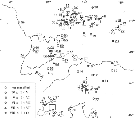
Places referred by original sources were marked
and indicated with their presumable intensity. Places mentioned in the earthquake
literature, as by Sieberg (1940), Karnik et al. (1956), Reindl et al. (1902-1903)
or Giessberger (1924) have been marked by open circles; this means that at
present this source has not been justified, and an intensity has not yet
been assessed.
The map also shows towns, taken from Sieberg
(1940), where the earlier and smaller earthquake of November 23rd, 1690 was
felt. One gets the impression that these locations drop into an area with
anomalous high observation density of the Villach earthquake of December
4, 1690. Thus, it seems thinkable, that several of the contemporary witnesses
have mixed up these two events. Future studies will bring to light, whether
this suspicion can be confirmed or not.
Effects of the earthquake in the epicentral area
and at Villach
The area of Villach was administrated by the
authorities of the bishop of Bamberg. Therefore a short line of communication
existed between Villach and places near Bamberg. Convincing and clear
contemporary sources of this shock have been found in the epicentral area
Villach, Gmünd, Nöring, Millstadt, Völkermarkt, St. Paul,
Spittal a.d. Drau and Klagenfurt, where the event caused severe building
damages. At this place we will discuss sources about Villach in more detail,
as the building damage and the number of victims show that this town has
been suffered the most. In Villach 24 persons died during or after the earthquake
as we know from the list of casualties (ACSJ, 1690). It strikes, that most
of the victims are women and children. 244 citizens of Villach (Klein, 1980)
owned houses and were registered in 1667 as having civil rights. The number
of victims, compared with the assumed total population of 3000, seems rather
low. The sources refer to building damages in a rather general way. We know
that the tower of the church St. Jacob tumbled down. But it cannot be traced
out exactly which houses collapsed, as the first map of Villach appeared
in Bamberg in 1738 (GAB, 1738) 48 years after the earthquake. The map indicates
buildings in bad structural condition, but they may be damaged by the great
fire in 1713, which destroyed a part of the town. After the earthquake the
whole town was in reconstruction scaffoldings for decades (Reindl, 1902-1903).
During the 18th century it had been rebuilt.
Outlook
This work is part of and investigation of the
Villach earthquake, which will be published in the series of "Monographs
of Historical Earthquakes in Central Europe". It is financially supported
by Project Nr. P8935 "Historische Seismizität im Alpin-Pannonischen
Raum" of the Fund of Supporting Scientific Research in Austria.
References
ACSJ (Archive of the Church St. Jacob, Villach),
1690. Totenfaszikel, 1.
Barbano, M.S. et al., 1994. Sources for the study of the Eastern Alps earthquakes
in the turn of the 17th century. this volume.
Eisinger, U., 1991. Typology of earthquake text. The Carinthian earthquake
of 1690. In: J. Kozak (Editor), Proc. 3rd ESC Workshop on "Historical Earthquakes
in Europe", Liblice by Prague, 4-6 April 1990, pp. 241-251.
GAB (Government Archive of Bamberg), 1738. Roppelt-Kataster für die
Stadt Villach, Rep. A 221/7, ms. 2919, p.15f.
Giesseberger, H., 1924. Die Erdbeben Bayerns. 1. Teil, Abhandlungen der
Bayerischen Akademie der Wissenschaften, Math., Nat. Klasse Bd. 29,
München.
Karnik, V., Michal, E. and Molnar, A., 1956. Erdbebenkatalog der Tschechoslowakei
bis zum Jahre 1956. Travaux de l'Institute Géophysique de l'Académie
Tschécoslovaque des Sciences, 69, Geofysikální
Sbornik.
Klein, K., 1980. Daten der Siedlungsgeschichte bis ins 16. Jarhundert.
Materialien zu Wirtchafts- und Sozialgeschichte, 4, p. 128, Vienna.
Hammerl, Ch., 1992. Das Erdbeben vom 25. Jänner 1348 ñ Rekonstruktion
des Naturereignisses. Diss. Univ. Wien, Vienna, 256 pp.
Postpischl, D. (Editor), 1985. Catalogo dei terremoti italiani dall'anno
1000 al 1980. Quad. Ric. Scient., 114, 2B, Bologna.
Reindl, J., 1902-1903. Die Erdbeben der geschichtlichen Zeit im Königreiche
Bayern. Die Erdbebenwarte, 2.
Sieberg, A., 1940. Beiträge zum Erdbebenkatalog Deutschlands und
angrenzender Gebiete für die Jahre 58 bis 1799. Mitteilungen des Deutschen
Reichs-Erdbebendienstes, Heft 2, Berlin.
Toperczer, M. and Trapp, E., 1950. Ein Beitrag zur Erdbebengeographie
Österreichs nebst Erdbebenkatalog 1904-1948 und Chronik der Starkbeben.
Mitteilungen der Erdbeben Kommission, 65, pp. 1-59.
[Top]
[Vol.1]
[Vol.2]
[Deliverables and queries]
[Presentation]
[Homepage]