ASMI Archivio Storico Macrosismico ItalianoItalian Archive of Historical Earthquake Data


|
Rovida A., Locati M., Camassi R., Lolli B., Gasperini P., Antonucci A., 2022. Catalogo Parametrico dei Terremoti Italiani (CPTI15), versione 4.0. Istituto Nazionale di Geofisica e Vulcanologia (INGV). https://doi.org/10.13127/CPTI/CPTI15.4 [link
 ] ] |
||||
| DataDate | 1743-02-20 | |||
|
|
39.847, 18.774 | |||
|
► 84 MDPs Imax 9-10 MCS Galli and Naso, 2008 | |||
|
Galli P., Naso G., 2008. The “taranta” effect of the 1743 earthquake in Salento (Apulia, southern Italy). Bollettino di Geofisica Teorica ed Applicata 49, 2, 177-204. [link ] [Altri terremoti dallo studioOther earthquakes from this study ] |
||||
| Io | 9 | |||
| Mw | 6.68 ± 0.12 | |||
| CatalogoCatalogue | DataDate | Lat | Lon | H | M | Io | RiferimentoReference | ||
|---|---|---|---|---|---|---|---|---|---|
| EPICAv1.1 | 1743-02-20 | 39.847 | 18.774 | -- | Mw 6.75 | 9 | |||
|
Rovida A., Antonucci A., 2021. EPICA - European PreInstrumental earthquake CAtalogue, version 1.1. Istituto Nazionale di Geofisica e Vulcanologia (INGV). https://doi.org/10.13127/epica.1.1 [link ] [Altri terremoti dallo studioOther earthquakes from this study ] |
|||||||||
|
Galli P., Naso G., 2008. The “taranta” effect of the 1743 earthquake in Salento (Apulia, southern Italy). Bollettino di Geofisica Teorica ed Applicata 49, 2, 177-204. [link ] |
|||||||||
|
Rovida A., Locati M., Camassi R., Lolli B., Gasperini P. (eds), 2016. CPTI15, the 2015 version of the Parametric Catalogue of Italian Earthquakes. Istituto Nazionale di Geofisica e Vulcanologia (INGV). https://doi.org/10.6092/INGV.IT-CPTI15 [link ] |
|||||||||
| CFTI5med | 1743-02-20 16:30 | 40.246 | 18.049 | -- | MM 6.90 | 9 | -- | ||
|
Guidoboni E., Ferrari G., Mariotti D., Comastri A., Tarabusi G., Sgattoni G., Valensise G., 2018. CFTI5Med, Catalogo dei Forti Terremoti in Italia (461 a.C.-1997) e nell'area Mediterranea (760 a.C.-1500). Istituto Nazionale di Geofisica e Vulcanologia (INGV). https://doi.org/10.6092/ingv.it-cfti5 [link ] [Altri terremoti dallo studioOther earthquakes from this study ] |
|||||||||
| SHEEC | 1743-02-20 16:30 | 39.846 | 18.772 | -- | Mw 7.10 | 9 | CFTI3 | ||
|
Stucchi M., Rovida A., Gomez Capera A.A., Alexandre P., Camelbeeck T., Demircioglu M.B., Gasperini P., Kouskouna V., Musson R.M.W., Radulian M., Sesetyan K., Vilanova S., Baumont D., Bungum H., Fäh D., Lenhardt W., Makropoulos K., Martinez Solares J.M., Scotti O., Živcic M., Albini P., Batllo J., Papaioannou C., Tatevossian R., Locati M., Meletti C., Viganò D., Giardini D., 2013. The SHARE European Earthquake Catalogue (SHEEC) 1000-1899. Journal of Seismology, 17, 2, 523-544. https://doi.org/10.1007/s10950-012-9335-2 [link ] [Altri terremoti dallo studioOther earthquakes from this study ] |
|||||||||
|
Boschi E., Guidoboni E., Ferrari G., Mariotti D., Valensise G., Gasperini P. (eds), 2000. Catalogue of Strong Italian Earthquakes from 461 B.C. to 1997. Annali di Geofisica, 43, 4, 609-868. [link ] |
|||||||||
| CPTI11 | 1743-02-20 16:30 | 39.852 | 18.777 | -- | Mw 7.13 | 9 | CFTI3 | ||
|
Rovida A., Camassi R., Gasperini P.,Stucchi M.(eds.), 2011. CPTI11, the 2011 version of the Parametric Catalogue of Italian Earthquakes. Istituto Nazionale di Geofisica e Vulcanologia (INGV), Milano, Bologna. https://doi.org/10.6092/INGV.IT-CPTI11 [link ] [Altri terremoti dallo studioOther earthquakes from this study ] |
|||||||||
|
Boschi E., Guidoboni E., Ferrari G., Mariotti D., Valensise G., Gasperini P. (eds), 2000. Catalogue of Strong Italian Earthquakes from 461 B.C. to 1997. Annali di Geofisica, 43, 4, 609-868. [link ] |
|||||||||
| CFTI4med | 1743-02-20 16:30 | 40.250 | 18.050 | -- | MM 6.90 | 9 | -- | ||
|
Guidoboni E., Ferrari G., Mariotti D., Comastri A., Tarabusi G., Valensise G., 2007. CFTI4Med, Catalogue of Strong Earthquakes in Italy (461 B.C.-1997) and Mediterranean Area (760 B.C.-1500). INGV-SGA. http://storing.ingv.it/cfti4med/ [link ] [Altri terremoti dallo studioOther earthquakes from this study ] |
|||||||||
| CPTI04 | 1743-02-20 16:30 | 39.850 | 18.780 | -- | Mw 7.08 | 9-10 | CFTI2 | ||
|
CPTI Working Group, 2004. Catalogo Parametrico dei Terremoti Italiani, versione 2004 (CPTI04). Istituto Nazionale di Geofisica e Vulcanologia (INGV), Bologna. https://doi.org/10.6092/INGV.IT-CPTI04 [link ] [Altri terremoti dallo studioOther earthquakes from this study ] |
|||||||||
|
Boschi E., Guidoboni E., Ferrari G., Valensise G. and Gasperini P. (eds.), 1997. Catalogo dei forti terremoti in Italia dal 461 a.C. al 1990, vol. 2. ING-SGA, Bologna, 644 pp. [link ] |
|||||||||
| Papazachos & P., 2003 | 1743-02-20 | 39.200 | 20.100 | n | Mw 7.10 | 8 | -- | ||
|
Papazachos B.C., Papazachou C., 2003. The earthquakes of Greece. Ziti publications, Thessaloniki, Greece, 286 pp. (in Greek). [link ] [Altri terremoti dallo studioOther earthquakes from this study ] |
|||||||||
| CFTI3 | 1743-02-20 16:30 | 39.850 | 18.783 | -- | Mw 7.30 | 9 | -- | ||
|
Boschi E., Guidoboni E., Ferrari G., Mariotti D., Valensise G., Gasperini P. (eds), 2000. Catalogue of Strong Italian Earthquakes from 461 B.C. to 1997. Annali di Geofisica, 43, 4, 609-868. [link ] [Altri terremoti dallo studioOther earthquakes from this study ] |
|||||||||
| CPTI99 | 1743-02-20 16:30 | 39.850 | 18.780 | -- | Ms 6.90 | 9-10 | CFTI2 | ||
|
CPTI Working Group, 1999. Catalogo Parametrico dei Terremoti Italiani. ING, GNDT, SGA, SSN, Bologna, 92 pp. https://doi.org/10.6092/INGV.IT-CPTI99 [link ] [Altri terremoti dallo studioOther earthquakes from this study ] |
|||||||||
|
Boschi E., Guidoboni E., Ferrari G., Valensise G. and Gasperini P. (eds.), 1997. Catalogo dei forti terremoti in Italia dal 461 a.C. al 1990, vol. 2. ING-SGA, Bologna, 644 pp. [link ] |
|||||||||
| NT4.1 | 1743-02-20 16:30 | 39.667 | 19.000 | -- | Ms 7.00 | 10-11 | ENEL, 1985 | ||
|
Camassi R. and Stucchi M. (eds), 1997. NT4.1: un catalogo parametrico di terremoti di area italiana al di sopra della soglia di danno (versione 4.1.1). Milano, 93 pp. [link ] [Altri terremoti dallo studioOther earthquakes from this study ] |
|||||||||
|
ENEL, 1985. Studi e indagini per l'accertamento della idoneità tecnica delle aree suscettibili di insediamento di impianti nucleari per le Regioni Piemonte, Lombardia e Puglia: indagini di sismica storica. Rapporti tecnici predisposti da ISMES-SGA, Roma. |
|||||||||
| CFTI2 | 1743-02-20 16:30 | 39.850 | 18.783 | -- | Mw 7.00 | 9 | -- | ||
|
Boschi E., Guidoboni E., Ferrari G., Valensise G. and Gasperini P. (eds.), 1997. Catalogo dei forti terremoti in Italia dal 461 a.C. al 1990, vol. 2. ING-SGA, Bologna, 644 pp. [link ] [Altri terremoti dallo studioOther earthquakes from this study ] |
|||||||||
| CFTI | 1743-02-20 16:30 | 39.000 | 19.250 | -- | Mw 7.20 | 9 | -- | ||
|
Boschi E., Ferrari G., Gasperini P., Guidoboni E., Smriglio G., Valensise G. (eds), 1995. Catalogo dei forti terremoti in Italia dal 461 a.C. al 1980. ING-SGA, Bologna, 970 pp. [link ] [Altri terremoti dallo studioOther earthquakes from this study ] |
|||||||||
| Postpischl, 1985 | 1743-02-20 16:30 | 38.000 | 18.000 | -- | MM 5.60 | 9 | Margottini, 1985 | ||
|
Postpischl D., 1985. Catalogo dei terremoti italiani dall'anno 1000 al 1980. Quaderni della Ricerca Scientifica, 114, 2B, Bologna, 239 pp. [Altri terremoti dallo studioOther earthquakes from this study ] |
|||||||||
|
Margottini C., 1985. The earthquake of February 20, 1743 in the Ionian Sea. In: Postpischl D. (ed.), Atlas of isoseismal maps of Italian earthquakes, Quaderni della Ricerca Scientifica, 114, 2A, Roma, 62-63. |
|||||||||
| Shebalin et al., 1974 | 1743-02-20 | 39.000 | 20.000 | -- | -- | -- | -- | ||
|
Shebalin N.V., Karnik V., Hadzievski D. (eds), 1974. Catalogue of earthquakes of the Balkan region. I, UNDP-UNESCO Survey of the seismicity of the Balkan region. Skopje, 600 pp. [link ] [Altri terremoti dallo studioOther earthquakes from this study ] |
|||||||||
catalogo parametricoparametric catalogue
Scarica i parametri di tutti i cataloghi in formato QuakeML Download the parameters from all catalogues as QuakeML XML

|
Papadopoulos G. A.,Triantafyllou I., 2025. A Revision of Historical Earthquakes in the Ionian Sea, Greece: Island of Lefkada. GeoHazards, 6(1), 7. https://doi.org/10.3390/geohazards6010007
he central Ionian Sea is one of the most seismogenic areas in the Mediterranean Sea region. In particular, the island of Lefkada, Greece, has experienced many catastrophic earthquakes. The historical seismicity of Lefkada has been revised by utilizing published and little-known macroseismic information sources, e.g., administrative documents, letters, marginal notes, and eyewitness accounts. We organized a new descriptive and parametric catalogue of 44 earthquakes that had their maximum macroseismic intensity in Lefkada and covered the time interval from the 15th century A.D. up to 1911. Earthquake dates, origin times, intensities, magnitudes, and epicentral coordinates were estimated or revised. Magnitudes estimated in previous catalogues in general are larger with respect to our magnitude determinations, possibly due to different calculation methods. The descriptive part of the catalogue includes descriptions of the earthquakes’ impact on buildings and of environmental effects, e.g., landslides and local tsunamis. The catalogue completeness gradually increases with time but is likely complete for the entire period examined lower magnitude threshold Mw = 6.0. One important yet puzzling earthquake is the large one that reportedly ruptured the Strait of Otranto and damaged an unprecedentedly extensive region in Italy, Albania, and Greece, including Lefkada, on 9/20 February 1743. Little-known documents revealed that the heavy destruction supposedly caused in Lefkada was very likely due to amalgamated information regarding local earthquakes and the large one.
20 febbraio 1743, 15h20 February 1743, 15h
|

|
Barbano M.S., Castelli V., Galea P., Pirrotta C., 2021. Materiali per una storia sismica delle Isole Maltesi. Quaderni di Geofisica, 171, 1358. https://doi.org/10.13127/qdg/171
We present the results of an ItalianMaltese research, carried out to collect the macroseismic data needed to update the seismic catalogue of the Maltese Islands [Galea, 2007]. In this work we adopted the most uptodate criteria developed by Italian historical seismology, obtaining results that significantly improve knowledge, particularly for the 16501923 timewindow. Several previously unknown local earthquakes have been identified and evidence has been found of earthquake damage caused to the Maltese Islands both by earthquakes probably located in the Sicilian Channel (1658, 1780, 1861), and by some strong Greek earthquakes (1756, 1810, 1846). The European macroseismic scale 1998 (EMS98, Grünthal [1998]) was used to assign macroseismic intensities. Basic information on seismicinduced natural phenomena (landslides, tsunamis) was also collected, to be used as a further constraint on the location and size of associated earthquakes, or for paleoseismological studies. As an added bonus, the study collected evidence of some Sicilian earthquakes unknown to seismological literature and data useful to improve the macroseismic database of already known Sicilian and Greek earthquakes.
20 febbraio 1743, 16:3020 February 1743, 16:30
Mar Ionio
► Informazioni su vittime e feritiInformation about fatalities
Dead: none in Malta (according to the sources).Vittime: nessuna a Malta (fonti). |

|
Guidoboni E., Ferrari G., Mariotti D., Comastri A., Tarabusi G., Sgattoni G., Valensise G., 2018. CFTI5Med, Catalogo dei Forti Terremoti in Italia (461 a.C.-1997) e nell'area Mediterranea (760 a.C.-1500). Istituto Nazionale di Geofisica e Vulcanologia (INGV). https://doi.org/10.6092/ingv.it-cfti5
The Catalogue lists earthquakes that occurred in Italy between 461 B.C. and 1997, and earthquakes that occurred in the general Mediterranean area between the VIII century b.C. and the XV century. This version (CFTI5Med) features: the retrieval and formatting of over 23,000 original bibliographic documents, transcribed or printed, nearly 50% of those utilized in the CFTI5Med. These documents are now available on-line as fully searchable pdf files; a full geological reinterpretation, georeferencing and reprocessing of over 2,300 descriptions of earthquake-induced environmental effects, which are now all available and searchable in a user-friendly web-GIS environment; the elaboration of a number of texts and commentaries that were missing from the CFTI4Med version of the catalogue; a totally re-designed and more efficient web- and web-GIS interface. The new Catalogo dei Forti Terremoti in ltalia includes 1,259 earthquakes that occurred in Italy (98 of which are currently considered false). No commentaries on the main earthquake effects were available in the previous version of the catalogue for 87 of such events as they had not been updated with respect to the information supplied in Guidoboni e Comastri (2005) for the 1000 AD-1500 AD time interval. The commentaries concerning the most significant effects of Italian medieval earthquakes have now been elaborated and are available along with the information on more recent events. For the remainder of the earthquakes first presented with the CFTI4Med - those that occurred in the general Mediterranean area away from the Italian coasts - the new catalogue provides only the felt reports and basic epicentral parameters.
20 febbraio 1743, 16:3020 February 1743, 16:30
Basso Ionio
► Informazioni su vittime e feritiInformation about fatalities
Dead: around 200 total (detailed in the study).Vittime: circa 200 totali (dettagliate nello studio). Injured: around 200 in Nardò.Feriti: circa 200 a Nardò. |

|
Nappi R., Gaudiosi G., Alessio G., De Lucia M., Porfido S., 2017. The environmental effects of the 1743 Salento earthquake (Apulia, southern Italy): a contribution to seismic hazard assessment of the Salento Peninsula. Nat Hazards 86, S295-S324. https://doi.org/10.1007/s11069-016-2548-x
The aim of this study was to provide a contribution to seismic hazard assessment of the Salento Peninsula (Apulia, southern Italy). It is well known that this area was struck by the February 20, 1743, earthquake (I 0 = IX and M w = 7.1), the strongest seismic event of Salento, that caused the most severe damage in the towns of Nardò (Lecce) and Francavilla Fontana (Brindisi), in the Ionian Islands (Greece) and in the western coast of Albania. It was also widely felt in the western coast of Greece, in Malta Islands, in southern Italy and in some localities of central and northern Italy. Moreover, the area of the Salento Peninsula has also been hit by several low-energy and a few high-energy earthquakes over the last centuries; the instrumental recent seismicity is mainly concentrated in the western sector of the peninsula and in the Otranto Channel. The Salento area has also experienced destructive seismicity of neighboring regions in Italy (the Gargano Promontory in northern Apulia, the Southern Apennines chain, the Calabrian Arc) and in the Balkan Peninsula (Greece and Albania). Accordingly, a critical analysis of several documentary and historical sources, as well as of the geologic–geomorphologic ground effects due to the strong 1743 Salento earthquake, has been carried out by the authors in this paper; the final purpose has been to re-evaluate the 1743 MCS macroseismic intensities and to provide a list of newly classified localities according to the ESI-07 scale on the base of recognized Earthquake Environmental Effects. The result is a quite different damage scenario due to this earthquake that could raise the seismic potential currently recognized for the Salento area, and consequently upgrade the seismic hazard classification of the Salento. Indeed it is important to remind that currently, despite the intense earthquake activity recorded not only in the Otranto Channel, but especially in Greece and Albania, this area is classified in the least dangerous category of the Seismic Classification of the Italian territory (IV category).
20 febbraio 1743, 16:3020 February 1743, 16:30
Salento
► Informazioni su vittime e feritiInformation about fatalities
Dead: several hundreds, of which many in Nardò and Francavilla Fontana, and several in Amaxichi (Lefkada) and Kérkira (Corfù).Dead: alcune centinaia, di cui molte a Nardò e Francavilla Fontana, e diverse a Amaxichi (Lefkada) e Kérkira (Corfù). |

|
Galli P., Naso G., 2008. The “taranta” effect of the 1743 earthquake in Salento (Apulia, southern Italy). Bollettino di Geofisica Teorica ed Applicata 49, 2, 177-204.
The Salento Peninsula (Apulia, southern Italy), along with a few other regions in Italy, is traditionally considered a low seismic hazard area. However, in 1743 it was affected by the catastrophic effects (Imax=IX-X MCS) of an earthquake, that probably occurred offshore, in the Salento Plateau (Ionian Sea). Subsequent damage had a complex pattern, whereby some towns were almost razed to the ground and others, nearby, suffered only slight damage. By means of an integrated geological, geotechnical and geophysical analysis we tried to cast a light on the causes of this peculiar distribution of seismic shaking, which we finally modelled by means of a one-dimensional simulation. These results, together with the re-analysis of the macroseismic distribution of the earthquake, and the seismotectonic knowledge of the region, suggest that the 1743 event was a strong, deep one that occurred far from Salento. The event induced high amplification, mainly in the villages (i.e., Nardò and Francavilla Fontana) founded on thin Pleistocene basins filled with soft sediments. The highest amplification peak, due to both the spectral content of the earthquake, as well as to the resonant period of the sedimentary basins, occurred in the same frequency range as most of the buildings of the time, that is ~3 Hz. This terrific double-resonance effect seems to be the main cause for the highest intensity evaluated in Salento, which, would otherwise, have been struck by effects possibly close to VII-VIII MCS.
20 febbraio 174320 February 1743
Salento
► Informazioni su vittime e feritiInformation about fatalities
Dead: yes, in Catanzaro and Reggio Calabria; between 160 to more than 400 (according to different sources) in Nardò, 7 in Lefkada, a dozen in Francavilla Fontana, none in Galatone.Vittime: si, a Catanzaro e Reggio Calabria; tra 160 a più di 400 (in base alle divrse fonti) a Nardò, 7 a Lefkada, una dozzina a Francavilla Fontana, nessuna a Galatone. Injured: hundreds in Nardò; none in Galatone.Feriti: centinaia a Nardò; nessuna a Galatone. |

|
Galea P., 2007. Seismic history of the Maltese islands and considerations on seismic risk. Annals of Geophysics, 50, 6, 725-740. https://doi.org/10.4401/ag-3053
A historical catalogue of felt earthquakes in the Maltese islands has been compiled dating back to 1530. Although no fatalities were officially recorded during this time as a direct consequence of earthquake effects, serious damage to buildings occurred several times. In the catalogue time period, the islands experienced EMS-98 intensity VII-VIII once (11 January 1693) and intensity VII, or VI-VII five times. The northern segment of the Hyblean-Malta plateau is the source region which appears to pose the greatest threat, although large Greek events and lower magnitude Sicily Channel events also produced damage. Estimates of return periods for intensity ≥V are presented, and it is shown that expected peak ground accelerations justify the implementation of, at least, minimum anti-seismic provisions. The rapid and continual increase in the local building stock on the densely-populated islands warrants the implementation of an appropriate seismic building code to be enforced.
20 febbraio 1743, 16:3020 February 1743, 16:30
Ionian Sea
|

|
Guidoboni E., Ferrari G., Mariotti D., Comastri A., Tarabusi G., Valensise G., 2007. CFTI4Med, Catalogue of Strong Earthquakes in Italy (461 B.C.-1997) and Mediterranean Area (760 B.C.-1500). INGV-SGA. http://storing.ingv.it/cfti4med/
20 febbraio 1743, 16:3020 February 1743, 16:30
Basso Ionio
►
86 MDPs
Imax 9 MCS
|

|
University of Thessaloniki, 2003. Macroseismic Data used for the compilation of Papazachos and Papazachou (2003) catalogue. In: Online Macroseimic Data of Southern Balkan area.
Within the module NA4: "A Distributed Archive of Historical Earthquake Data" (coordinator of the module Dr. M. Stucchi) of the EU-NERIES project, the "Macroseismic Database of the Southern Balkan area" was compiled on a joint effort of ITSAK (Ch. A. Papaioannou and A.S. Savvaidis), as module Partner, and the Geophysical Laboratory of the University of Thessaloniki (B.C. Papazachos, as principal researcher, and C.B. Papazachos) for the time period 1000-1999. The database is temporarily hosted by the INGV-MI. The source of the data (macroseismic Intensity Data Points) are:
20 febbraio 174320 February 1743
Corfu
►
5 MDPs
Imax 9 MM
|

|
Boschi E., Guidoboni E., Ferrari G., Mariotti D., Valensise G., Gasperini P. (eds), 2000. Catalogue of Strong Italian Earthquakes from 461 B.C. to 1997. Annali di Geofisica, 43, 4, 609-868.
20 febbraio 1743, 16:3020 February 1743, 16:30
Basso Ionio
►
77 MDPs
Imax 9 MCS
|

|
Ambraseys N.N., Finkel C., 1999. Unpublished Ottoman archival information on the seismicity of the Balkans during the period 1500-1800. In: E. Zachariadou (ed), Natural Disasters in the Ottoman Empire, Institute for Mediterranean Studies, Halcyon Days in Crete III, A Symposium Held in Rethymnon (Greece), 10-12 January 1997, 89-107.
The addition of Ottoman sources to the corpus of material available for the study of the seismicity of the successor states of the Ottoman Empire, appears to offer a chance to enhance our understanding of the earthquake hazard of these regions. Among the voluminous archival legacy of the Ottoman bureaucracy, whose reach extended into every village, we might hope to find a somewhat full record of the effects of earthquakes throughout the empire. The question which we want to pose here is how much Ottoman archival sources add to written material in other languages for the area and period under consideration, that is, Albania, Bulgaria, Greece and former Yugoslavia during the three centuries between 1500 and 1800. The type of data which is of use to the earth scientist to assess earthquake hazard is that which can be accorded some numerical value that can be used to determine chiefly the epicentral area of an earthquake, in terms of its geographic coordinates, and the size of the event, in terms of its magnitude. This requires knowledge of the distribution of the intensity of an earthquake, that is the degree of the severity of damage or shaking, at as many sites as possible, including those at great distances where the shock was merely felt, as well as knowledge of the effects of the earthquake on the ground itself and of its association with secondary effects such as the generation of landslides and seismic sea waves. The two pieces of information which are of interest to the earth scientist and which need to be assessed from written sources, are the location (epicentral region) and size (magnitude) of an earthquake; that is: (a) where and how large was the area of maximum destruction and (b) how far away the shock was felt. Other information such as the human and material losses incurred, and the social and economic impact and consequences of the event are of interest more to the historian than to the earth scientist, although sometimes this kind of information can help to assess the size of the epicentral region. The method we employed to retrieve information has been first to identify earthquakes in the Ottoman Balkans during the period 1500 to 1800 from published occidental sources, and then to look for additional information in Greek and Slavonic (mostly) published documents. Having thus prepared a preliminary list of earthquakes, supplementary information was sought in Ottoman and Italian archival material and consular archives; this supplementary information proved invaluable for the second half of the 17th and for the 18th centuries. In the process, quite a few new events were found which added considerable information that led to additional searches in other sources. The Ottoman archival material utilised for the present study consists for the most part of the documents from the Maliyeden Müdevver (MMD) series in the Ottoman central archives, the Başbakanlık Osmanlı Arşivi (BBA) in Istanbul. These documents and the registers into which they were copied for the central bureaucracy record, are extremely disparate in topic but have in common that they all concern financial matters, as do most of the other Ottoman documents utilised here. The aim of the writers of the documents which refer to earthquake damage was to assess the exact costs for the repair or reconstruction of structures affected by the shock, to dictate the administrative route to be followed in effecting the repairs and to ensure that the money assigned was spent as decreed. Another series of Ottoman documents which might have been useful and have given further information from disparate sites is the records of the kadi courts, but those for the Balkans are for the most part lost or cannot be located. Among the most detailed documents are those relating to the repair of public buildings, in which are found a record of the dimensions of the damaged part of a structure and a complete accounting of the costs involved. The material relating to each event located is copious, but in isolation is for us of little value since it usually relates to damage to individual buildings and in particular to military structures. It is only rarely that there is any reference to damage elsewhere or to casualties and material losses. Venetian correspondence relating to earthquakes in our region shares some of the same characteristics: both Ottoman and Venetian sources suffer from a lack of information regarding non-pecuniary matters, the very information which is of most interest to the scientist. Both Ottoman and Venetian documents rarely name affected sites other than those that had petitioned for or required financial as¬sistance for repairs or reconstruction, seldom mention casualty figures and almost never list sites at which an earthquake was felt without damage. Each type of source reflects the concerns of its author. By contrast with the narrow administrative concerns of the Ottoman bureaucracy, the contemporary accounts of merchants and travellers, for instance, provide an impressionistic and personal picture of the effects of an earthquake, while church records are often ca-reful in giving the date of an event - which the Ottoman records are usually not; consular reports and newspapers give a wider view of the event but are few until a period well into the 17th century. Thus, for the region and period under investiga¬tion here, such vital features of an earthquake must be retrieved from these types of non-Ottoman sources. When we consider the diversity of sources, the different languages involved and the paucity of libraries of the relevant types of material, it is clear that such re¬search is extremely time-consuming. This is especially true with respect to the retrieval of earthquake-related material from Ottoman sources. Indeed, when we consider the following statistic, we may wonder whether it is cost-effective: of some 500 earthquakes known from non-Ottoman sources for the period and area of our interest, only 41 were found in Ottoman sources and of these 21 are already known from other sources. Most Ottoman documents relating to earthquakes provide no date for the events they describe and only a terminus ante quem can be established from the date of their issue. This makes it almost impossible to establish simultaneity and the association of such information with earthquakes known from other sources can only be tentative. Some of the entries in the catalogue which we present here may relate to the same event but at present there is not sufficient information to justify their amalgamation, or their association with known events. Another difficulty in assessing the severity or intensity of an earthquake at a particular locality is that in many cases earthquake damage in Ottoman documents is reported together with or as a result of more than one cause, such as ageing, weathering, neglect or military operations, or as the result of more than one earth-quake. The collapse of or damage to a dilapidated building is not always an indication of severe shaking but rather a measure of the vulnerability of the structure. Large, distant earthquakes can destroy this class of buildings at distances of hundreds of kilometres from where the earthquake happened, particularly those built on soft and saturated ground, and their collapse can give the false impression of severe shaking. The lack of interest of the Ottoman administration in the maintenance of public buildings often contributes to false estimates of intensity. Summary case-histories of the 41 earthquakes occurring in the Balkans between 1500 and 1800 which are recorded in hitherto unpublished Ottoman archival sources are presented below, and listed in Table 1. Fig. 1 and Table 2 show the location of sites mentioned in the text together with modem names.
20 febbraio 174320 February 1743
Patra
|

|
Boschi E., Guidoboni E., Ferrari G., Valensise G. and Gasperini P. (eds.), 1997. Catalogo dei forti terremoti in Italia dal 461 a.C. al 1990, vol. 2. ING-SGA, Bologna, 644 pp.
20 febbraio 1743, 16:3020 February 1743, 16:30
Basso Ionio
►
76 MDPs
Imax 9 MCS
|

|
Boschi E., Ferrari G., Gasperini P., Guidoboni E., Smriglio G., Valensise G. (eds), 1995. Catalogo dei forti terremoti in Italia dal 461 a.C. al 1980. ING-SGA, Bologna, 970 pp.
20 febbraio 1743, 16:3020 February 1743, 16:30
Basso Ionio
77 MDPs
Imax 9 MCS |
Studies temporarily added by the userStudi aggiunti temporaneamente dall'utente |
|
Crea una selezioneCreate a seismicity buffer

Download PNG

| Year Mo Da Ho Mi Se | Epicentral area | NMDP | Lat | Lon | Io | Mw |
|---|---|---|---|---|---|---|
| 1638 06 08 09 45 | Crotonese | 41 | 39.279 | 16.812 | 10 | 6.76 |
| 1710 12 13 21 | Salento | 2 | 40.412 | 17.707 | 5 | 4.16 |
| 1713 01 03 | Bassa Murgia | 2 | 40.589 | 17.113 | 5-6 | 4.40 |
| 1743 02 20 | Ionio settentrionale | 84 | 39.847 | 18.774 | 9 | 6.68 |
| 1744 03 21 20 | Sila Piccola | 29 | 39.040 | 16.781 | 8 | 5.74 |
| 1822 07 14 | Crotonese | 4 | 39.282 | 16.903 | 6 | 4.63 |
| 1824 12 11 | Sila Greca | 4 | 39.540 | 16.588 | 7-8 | 5.33 |
| 1826 10 26 18 | Salento | 7 | 40.502 | 17.433 | 6-7 | 5.22 |
| 1832 03 08 18 30 | Crotonese | 99 | 39.079 | 16.919 | 10 | 6.65 |
| 1833 01 19 03 15 | Albania | 6 | ||||
| 1836 04 25 00 20 | Calabria settentrionale | 44 | 39.567 | 16.737 | 9 | 6.18 |
| 1836 05 22 07 55 | Calabria settentrionale | 1 | 39.574 | 16.635 | 5-6 | 4.40 |
| 1836 06 19 03 15 | Calabria settentrionale | 1 | 39.574 | 16.635 | 5 | 4.16 |
| 1836 07 27 07 30 | Calabria settentrionale | 1 | 39.574 | 16.635 | 5-6 | 4.40 |
| 1846 09 11 | Rossano | 1 | 39.574 | 16.635 | 5 | 4.16 |
| 1897 12 06 03 15 | San Giovanni in Fiore | 13 | 39.254 | 16.699 | 4 | 3.90 |
| 1909 01 20 19 58 | Salento | 32 | 40.178 | 18.031 | 5 | 4.51 |
| 1909 05 17 10 28 | Savelli | 12 | 39.312 | 16.777 | 5 | 4.16 |
| 1917 06 12 18 44 | Golfo di Taranto | 11 | 39.758 | 16.733 | 4-5 | 5.35 |
| 1928 09 03 01 40 | Cirò Marina | 1 | 39.369 | 17.128 | 5-6 | 4.40 |
| 1930 10 09 04 33 40.00 | Ionio settentrionale | 10 | 39.143 | 18.037 | 5 | 4.78 |
| 1932 01 02 23 36 | Ionio settentrionale | 16 | 39.065 | 17.555 | 5 | 5.52 |
| 1932 03 30 09 56 26.00 | Bassa Murgia | 28 | 40.587 | 16.858 | 5 | 4.54 |
| 1933 02 04 01 04 | Crotonese | 3 | 39.081 | 17.128 | 4 | 3.70 |
| 1941 12 13 19 14 | Golfo di Taranto | 40.200 | 16.900 | |||
| 1948 05 07 15 57 24.00 | Ionio settentrionale | 40.000 | 19.000 | |||
| 1969 07 02 10 31 21.00 | Calabria settentrionale | 39.510 | 16.640 | 4.57 | ||
| 1970 12 09 15 58 28.00 | Canale d'Otranto | 40.200 | 18.900 | 4.36 | ||
| 1973 04 13 08 12 57.00 | Sila Piccola | 19 | 39.046 | 16.772 | 6 | 4.62 |
| 1974 04 21 04 00 04.14 | Costa crotonese | 1 | 38.864 | 17.532 | 3.55 | |
| 1974 06 17 19 25 55.77 | Ionio settentrionale | 38.962 | 17.816 | 3.88 | ||
| 1974 06 29 22 32 02.90 | Ionio settentrionale | 39.648 | 18.833 | 4.07 | ||
| 1974 10 01 00 34 39.80 | Ionio settentrionale | 39.699 | 18.814 | 3.88 | ||
| 1974 10 07 11 43 39.78 | Ionio settentrionale | 39.786 | 18.915 | 4.46 | ||
| 1974 10 20 11 25 50.33 | Ionio settentrionale | 3 | 39.572 | 18.826 | 5.02 | |
| 1974 10 22 07 29 03.70 | Ionio settentrionale | 39.705 | 18.717 | 4.36 | ||
| 1974 11 23 07 52 28.22 | Ionio settentrionale | 39.774 | 18.810 | 4.46 | ||
| 1974 11 23 18 46 35.98 | Ionio settentrionale | 39.743 | 18.940 | 4.79 | ||
| 1976 10 22 11 23 27.26 | Ionio settentrionale | 39.724 | 18.928 | 4.68 | ||
| 1976 10 27 10 14 56.04 | Ionio settentrionale | 39.601 | 18.836 | 4.57 | ||
| 1976 11 06 20 57 04.36 | Ionio settentrionale | 39.606 | 18.772 | 4.57 | ||
| 1976 11 07 02 10 17.83 | Ionio settentrionale | 39.645 | 18.868 | 3.07 | ||
| 1976 11 08 18 08 40.52 | Ionio settentrionale | 39.220 | 18.606 | 4.07 | ||
| 1976 11 12 19 36 36.09 | Ionio settentrionale | 39.658 | 18.935 | 4.46 | ||
| 1976 11 13 05 20 36.75 | Ionio settentrionale | 39.666 | 18.975 | |||
| 1977 06 05 23 19 47.64 | Ionio settentrionale | 39.630 | 18.831 | 4.07 | ||
| 1977 08 15 21 10 32.51 | Calabria centrale | 37 | 38.789 | 17.026 | 5.21 | |
| 1984 06 23 00 37 03.06 | Sila Greca | 39.495 | 16.668 | 4.22 | ||
| 1984 10 23 20 49 30.48 | Golfo di Taranto | 39.804 | 16.721 | 4.07 | ||
| 1985 09 19 04 54 26.15 | Ionio settentrionale | 39.673 | 18.832 | 3.99 | ||
| 1988 04 13 21 28 27.56 | Golfo di Taranto | 272 | 39.682 | 16.879 | 6-7 | 4.86 |
| 1988 04 26 01 10 11.89 | Adriatico meridionale | 41.391 | 18.163 | 4.17 | ||
| 1990 01 24 03 51 08.32 | Crotonese | 21 | 39.113 | 16.773 | 5-6 | 3.26 |
| 1990 01 24 04 45 04.02 | Crotonese | 63 | 39.129 | 16.960 | 5 | 4.43 |
| 1990 01 24 16 18 59.77 | Crotonese | 26 | 39.165 | 16.787 | 5-6 | 4.01 |
| 1990 01 24 16 40 11.30 | Crotonese | 8 | 38.811 | 17.032 | 4-5 | 3.47 |
| 1991 04 18 19 24 03.06 | Piana di Metaponto | 26 | 40.415 | 16.804 | 4.13 | |
| 1991 04 24 13 22 16.11 | Sila | 48 | 39.260 | 16.722 | 5 | 4.04 |
| 1991 05 09 08 57 13.17 | Sila Greca | 18 | 39.429 | 16.587 | 5 | 3.54 |
| 1991 06 15 20 58 32.56 | Golfo di Squillace | 38.799 | 17.098 | 4.20 | ||
| 1992 08 20 00 57 23.47 | Ionio settentrionale | 38.840 | 17.889 | 4.01 | ||
| 1993 08 10 01 14 11.45 | Golfo di Taranto | 79 | 39.523 | 17.101 | 4-5 | 4.45 |
| 1994 01 07 18 30 12.46 | Golfo di Taranto | 26 | 40.204 | 17.320 | 4.03 | |
| 1995 04 17 03 26 17.34 | Costa calabra settentrionale | 13 | 39.601 | 17.080 | 4.06 | |
| 1995 08 08 07 53 44.72 | Piana di Sibari | 49 | 39.699 | 16.517 | 4-5 | 4.31 |
| 1996 06 01 12 28 23.23 | Bassa Murgia | 40.523 | 16.879 | 4.06 | ||
| 1998 07 07 01 59 51.92 | Ionio settentrionale | 39.307 | 17.591 | 4.05 | ||
| 1998 07 07 08 22 42.19 | Golfo di Taranto | 39.831 | 17.932 | 4.08 | ||
| 1999 01 17 19 32 17.43 | Ionio settentrionale | 39.172 | 17.535 | 4.62 | ||
| 1999 12 28 04 26 49.14 | Crotonese | 20 | 39.308 | 17.056 | 4-5 | 3.99 |
| 2001 09 23 21 16 56.97 | Golfo di Taranto | 39.767 | 18.001 | 4.96 | ||
| 2002 04 05 14 54 15.23 | Sila | 14 | 39.232 | 16.668 | 4 | 4.16 |
| 2002 04 17 06 42 54.66 | Costa calabra settentrionale | 66 | 39.683 | 16.879 | 4.84 | |
| 2004 04 17 05 14 14.53 | Golfo di Squillace | 126 | 38.952 | 16.930 | 4 | 4.21 |
| 2005 04 23 19 11 41.69 | Costa calabra settentrionale | 156 | 39.458 | 16.826 | 4 | 4.15 |
| 2006 04 17 02 44 06.43 | Costa calabra settentrionale | 135 | 39.613 | 17.119 | 4-5 | 4.76 |
| 2006 06 22 19 34 58.34 | Costa calabra settentrionale | 161 | 39.709 | 16.623 | 4.70 | |
| 2007 05 25 09 39 46.28 | Costa calabra settentrionale | 39.658 | 16.834 | 4.42 | ||
| 2007 08 01 00 07 54.92 | Crotonese | 39.003 | 17.176 | 4.41 | ||
| 2008 11 20 14 09 19.51 | Ionio settentrionale | 39.263 | 17.339 | 4.51 | ||
| 2011 03 25 18 31 31.50 | Golfo di Squillace | 38.869 | 16.973 | 4.10 | ||
| 2014 04 05 10 24 45.80 | Ionio settentrionale | 38.857 | 17.231 | 4.79 | ||
| 2014 09 05 10 10 18.22 | Ionio settentrionale | 39.170 | 18.798 | 4.06 | ||
| 2019 07 26 04 07 56.17 | Ionio settentrionale | 38.825 | 17.949 | 4.09 | ||
| 2019 10 15 11 54 52.51 | Crotonese | 39.212 | 17.146 | 4.11 | ||
| 2019 10 31 06 59 02.03 | Ionio settentrionale | 38.962 | 17.435 | 4.27 | ||
| 2020 04 03 03 52 04.07 | Ionio settentrionale | 39.076 | 17.222 | 4.15 | ||
| 2020 04 03 14 18 55.80 | Ionio settentrionale | 39.088 | 17.217 | 4.09 |
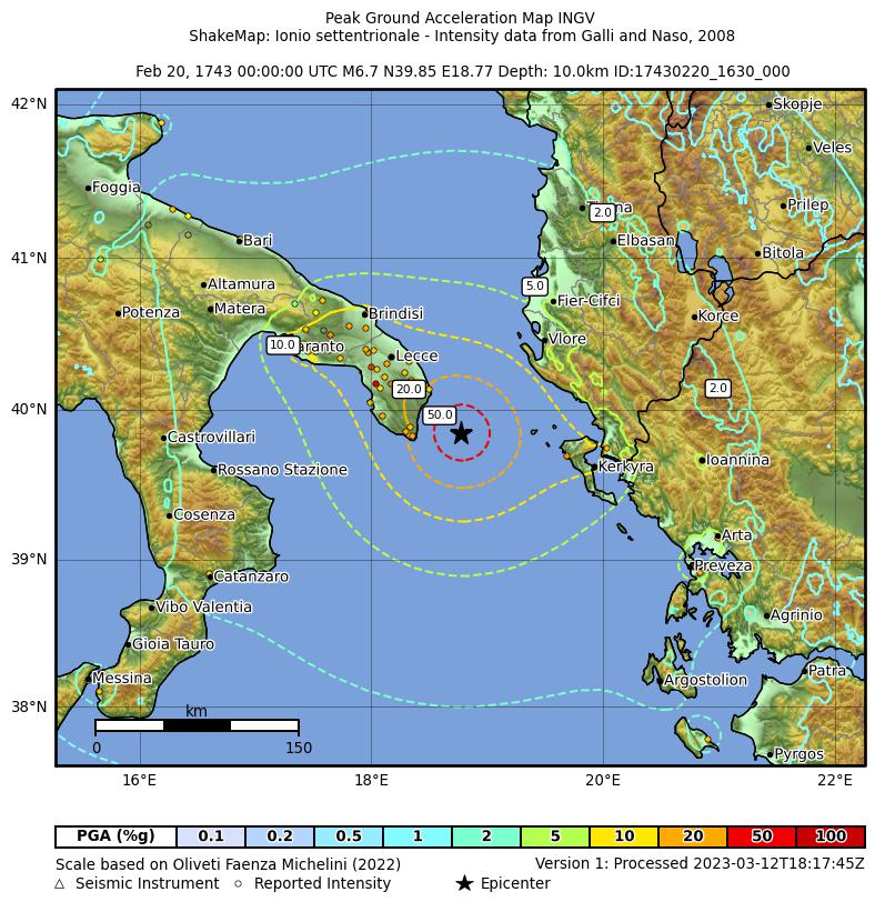
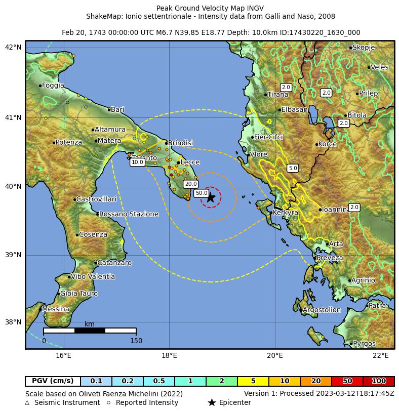
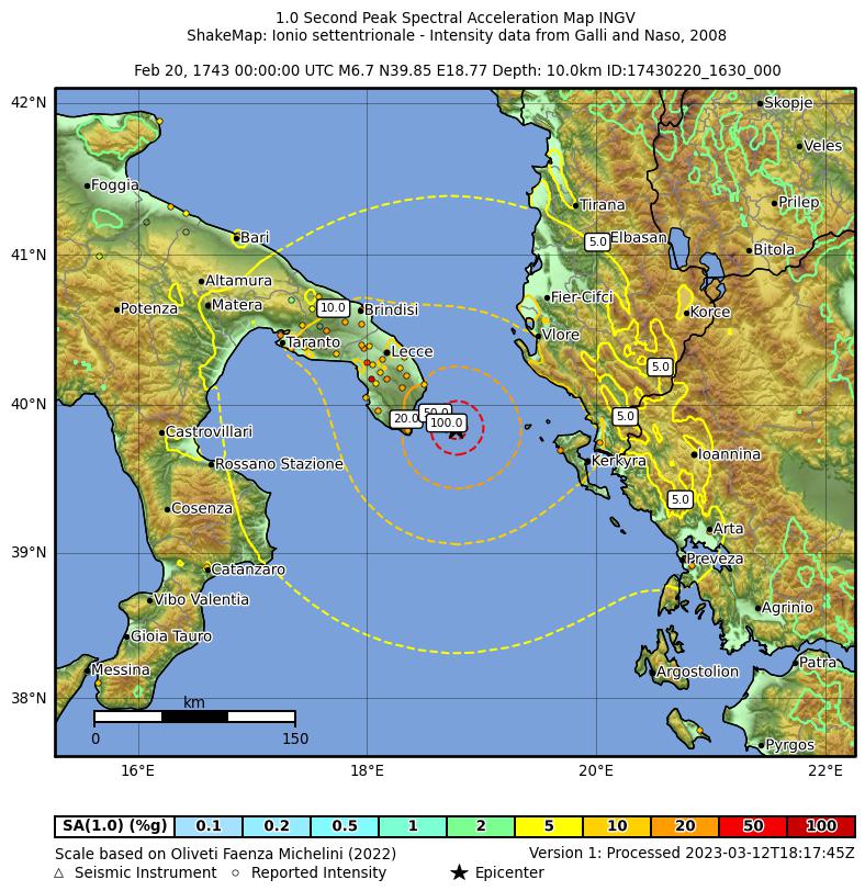
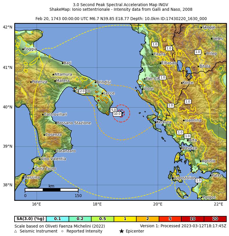
Shakemaps calcolate a partire dai dati macrosismici di DBMI15 (MDP da Galli and Naso, 2008)
secondo le procedure descritte in Michelini et al. 2020..
Queste mappe e relativi dati sono anche disponibili sul sito INGV Shakemap.
Shakemaps calculated from DBMI15 macroseismic data (MDP from Galli and Naso, 2008)
using procedures described in Michelini et al. 2020.
These maps and related data are available at the INGV Shakemap website also.


 |
Maramai, A., Graziani, L., Brizuela, B. (2019). Euro-Mediterranean Tsunami Catalogue (EMTC), version 2.0. Istituto Nazionale di Geofisica e Vulcanologia (INGV). https://doi.org/10.13127/TSUNAMI/EMTC.2.0 ► AbstractA unified catalogue containing 293 tsunamis generated in the European and Mediterranean seas since 6150 B.C. to current days is presented. It is the result of a systematic and detailed review of all the regional catalogues available in literature covering the study area, each of them having their own format and level of accuracy. The realization of a single catalogue covering a so wide area and involving several countries was a complex task that posed a series of challenges, being the standardization and the quality of the data the most demanding. A “reliability” value was used to rate equally the quality of the data for each event and this parameter was assigned based on the trustworthiness of the information related to the generating cause, the tsunami description accuracy and also on the availability of coeval bibliographical sources. Following these criteria we included in the catalogue events whose reliability ranges from 0 (“very improbable tsunami”) to 4 (“definite tsunami”). About 900 documentary sources, including historical documents, books, scientific reports, newspapers and previous catalogues, support the tsunami data and descriptions gathered in this catalogue. As a result, in the present paper a list of the 290 tsunamis with their main parameters is reported. The online version of the catalogue, available at http://roma2.rm.ingv.it/en/facilities/data_bases/52/catalogue_of_the_euro-mediterranean_tsunamis, provides additional information such as detailed descriptions, pictures, etc. and the complete list of bibliographical sources. Most of the included events have a high reliability value (3= “probable” and 4= “definite”) which makes the Euro-Mediterranean Tsunami Catalogue an essential tool for the implementation of tsunami hazard and risk assessment.
▼ Descrizione dell'eventoEvent description Epicenter coordinates, origin time, equivalent moment magnitude and earthquake intensity (MCS scale) from Rovida et al. (2016). Pasaric et al., (2012) report a strong earthquake occurred in the Salento peninsula (Apulia) and in the Ionian Islands on 20 February 1743, causing severe damage in Nardò, where most buildings were ruined. The towns of Lecce and Brindisi were heavily damaged, and the shock was felt in a very large area, involving Calabria, Sicily and Campania. In the harbour of Brindisi the sea withdrew, leaving the sea bottom visible (Scalese 1743; Cagnes and Scalese 1978). Ascoli F., (1886). La storia di Brindisi scritta da un marino. Rimini. Baratta M., (1901). I terremoti d' Italia F.lli Bocca, 950 pp., Torino (in Italian). Boschi E., Ferrari G., Gasperini P., Guidoboni E., Smriglio G. and Valensise G. (eds.), (1995). Catalogo dei forti terremoti in Italia dal 461 a.C. al 1980, ING-SGA, 970 pp., Bologna (in Italian). Cagnes P. and Scalese N., (1978). Cronaca dei sindaci di Brindisi (1529-1787). Introduction by R.Jurlaro, Ed. Amici della A. De Leo,636 pp., Brindisi (In Italian). Caputo M. and Faita G., (1984). Primo catalogo dei maremoti delle coste italiane. Atti dell’ Accademia Nazionale dei Lincei, Memorie Classe Scienze Fisiche Matematiche e Naturali, Serie VIII, Vol. XVII, 213-356, Roma (in Italian). Carrozzo M. T., De Visentini G., Giorgetti F. and Iaccarino E., (1973). General Catalogue of Italian Earthquakes, RT/PROT (73) 12, 212 pp., Rome. Mallet R., (1852). Third Report on the Facts of Earthquake Phenomena, Catalogue of Recorded Earthquakes from 160 B.C. to A.D. 1850. Report of the XXII Meeting of the British Association for the Advancement of Science, London, pp 176. Rovida A., Locati M., Camassi R., Lolli B., Gasperini P. (eds), (2016). Catalogo Parametrico dei Terremoti Italiani (CPTI15). Istituto Nazionale di Geofisica e Vulcanologia (INGV). https://doi.org/10.6092/INGV.IT-CPTI15 Scalese N., (1743). Annotazioni di Don Nicola Scalese all'epistola apologetica Joannis Baptistae Casimirii. (manuscript) Biblioteca Arcivescovile A. di Leo, Brindisi (in Italian). Soloviev S.L., Solovieva O.N., Go C.N., Kim K.S and Shchetnikov N.A., (2000). Tsunamis in the Mediterranean Sea 2000 B.C. - 2000 A.D.. Kluwer Academic Publishers. Tinti S. and Maramai A., (1996). Catalogue of tsunamis generated in Italy and in Côte d'Azur, France: a step towards a unified catalogue of tsunamis in Europe. Annali di Geofisica, vol. 39, n.6, 1253-1299. Tinti S., Maramai A. And Graziani L., (2004). The new catalogue of Italian tsunamis. Natural Hazards, 33, 3, pp. 439-465. Pasarić, M., Brizuela, B., Graziani, L., Maramai, A., Orlić, M., (2012). Historical tsunamis in the Adriatic Sea. Nat Hazards 61, pp.281–316. https://doi.org/10.1007/s11069-011-9916-3 Guidoboni E., Ferrari G., Mariotti D., Comastri A., Tarabusi G., Sgattoni G., Valensise G. (2018). CFTI5Med, Catalogo dei Forti Terremoti in Italia (461 a.C.-1997) e nell’area Mediterranea (760 a.C.-1500). Istituto Nazionale di Geofisica e Vulcanologia (INGV). https://doi.org/10.6092/INGV.IT-CFTI5 |
Non sono stati trovati link ad altri database online.No links to other online databases for this earthquake were found.


|


