ASMI Archivio Storico Macrosismico ItalianoItalian Archive of Historical Earthquake Data


|
Rovida A., Locati M., Camassi R., Lolli B., Gasperini P., Antonucci A., 2022. Catalogo Parametrico dei Terremoti Italiani (CPTI15), versione 4.0. Istituto Nazionale di Geofisica e Vulcanologia (INGV). https://doi.org/10.13127/CPTI/CPTI15.4 [link
 ] ] |
||||
| DataDate | 1887-02-23 05:21:50 | |||
|
|
43.891, 7.992 | |||
|
► 1511 MDPs Imax 10 MCS CFTI4med | |||
|
Guidoboni E., Ferrari G., Mariotti D., Comastri A., Tarabusi G., Valensise G., 2007. CFTI4Med, Catalogue of Strong Earthquakes in Italy (461 B.C.-1997) and Mediterranean Area (760 B.C.-1500). INGV-SGA. http://storing.ingv.it/cfti4med/ [link ] [Altri terremoti dallo studioOther earthquakes from this study ] |
||||
| Io | 9 | |||
| Mw | 6.27 ± 0.10 | |||
| CatalogoCatalogue | DataDate | Lat | Lon | H | M | Io | RiferimentoReference | ||
|---|---|---|---|---|---|---|---|---|---|
| EPICAv1.1 | 1887-02-23 05:21 | 43.891 | 7.992 | -- | Mw 6.24 | 9 | |||
|
Rovida A., Antonucci A., 2021. EPICA - European PreInstrumental earthquake CAtalogue, version 1.1. Istituto Nazionale di Geofisica e Vulcanologia (INGV). https://doi.org/10.13127/epica.1.1 [link ] [Altri terremoti dallo studioOther earthquakes from this study ] |
|||||||||
|
Guidoboni E., Ferrari G., Mariotti D., Comastri A., Tarabusi G., Sgattoni G., Valensise G., 2018. CFTI5Med, Catalogo dei Forti Terremoti in Italia (461 a.C.-1997) e nell'area Mediterranea (760 a.C.-1500). Istituto Nazionale di Geofisica e Vulcanologia (INGV). https://doi.org/10.6092/ingv.it-cfti5 [link ] |
|||||||||
|
Rovida A., Locati M., Camassi R., Lolli B., Gasperini P. (eds), 2016. CPTI15, the 2015 version of the Parametric Catalogue of Italian Earthquakes. Istituto Nazionale di Geofisica e Vulcanologia (INGV). https://doi.org/10.6092/INGV.IT-CPTI15 [link ] |
|||||||||
| CFTI5med | 1887-02-23 05:21:50 | 43.892 | 7.992 | -- | MM 6.30 | 9 | -- | ||
|
Guidoboni E., Ferrari G., Mariotti D., Comastri A., Tarabusi G., Sgattoni G., Valensise G., 2018. CFTI5Med, Catalogo dei Forti Terremoti in Italia (461 a.C.-1997) e nell'area Mediterranea (760 a.C.-1500). Istituto Nazionale di Geofisica e Vulcanologia (INGV). https://doi.org/10.6092/ingv.it-cfti5 [link ] [Altri terremoti dallo studioOther earthquakes from this study ] |
|||||||||
| FCAT-17 | 1887-02-23 05:50 | 43.833 | 8.000 | 12 | Mw 6.70 | 9 | SisFrance, 2014 | ||
|
Manchuel K., Traversa P., Baumont D., Cara M., Nayman E., Durouchoux C., 2018. The French seismic CATalogue (FCAT-17). Bullettin of Earthquake Engineering 16, 2227-2251. https://doi.org/10.1007/s10518-017-0236-1 [link ] [Altri terremoti dallo studioOther earthquakes from this study ] |
|||||||||
|
BRGM-EDF-IRSN/SisFrance, 2014. Histoire et caractéristiques des séismes ressentis en France. http://www.sisfrance.net/ [link ] |
|||||||||
| SisFrance, 2016 | 1887-02-23 05:50 | 43.833 | 8.000 | -- | -- | 9 | -- | ||
|
BRGM-EDF-IRSN/SisFrance, 2016. Histoire et caractéristiques des séismes ressentis en France. [link ] [Altri terremoti dallo studioOther earthquakes from this study ] |
|||||||||
| SisFrance, 2014 | 1887-02-23 05:50 | 43.833 | 8.000 | -- | -- | 9 | -- | ||
|
BRGM-EDF-IRSN/SisFrance, 2014. Histoire et caractéristiques des séismes ressentis en France. http://www.sisfrance.net/ [link ] [Altri terremoti dallo studioOther earthquakes from this study ] |
|||||||||
| SHEEC | 1887-02-23 05:21 | 43.564 | 8.245 | -- | Mw 6.62 | -- | CFTI4med | ||
|
Stucchi M., Rovida A., Gomez Capera A.A., Alexandre P., Camelbeeck T., Demircioglu M.B., Gasperini P., Kouskouna V., Musson R.M.W., Radulian M., Sesetyan K., Vilanova S., Baumont D., Bungum H., Fäh D., Lenhardt W., Makropoulos K., Martinez Solares J.M., Scotti O., Živcic M., Albini P., Batllo J., Papaioannou C., Tatevossian R., Locati M., Meletti C., Viganò D., Giardini D., 2013. The SHARE European Earthquake Catalogue (SHEEC) 1000-1899. Journal of Seismology, 17, 2, 523-544. https://doi.org/10.1007/s10950-012-9335-2 [link ] [Altri terremoti dallo studioOther earthquakes from this study ] |
|||||||||
|
Guidoboni E., Ferrari G., Mariotti D., Comastri A., Tarabusi G., Valensise G., 2007. CFTI4Med, Catalogue of Strong Earthquakes in Italy (461 B.C.-1997) and Mediterranean Area (760 B.C.-1500). INGV-SGA. http://storing.ingv.it/cfti4med/ [link ] |
|||||||||
| CPTI11 | 1887-02-23 05:21 | 43.715 | 8.161 | -- | Mw 6.97 | -- | CFTI4med | ||
|
Rovida A., Camassi R., Gasperini P.,Stucchi M.(eds.), 2011. CPTI11, the 2011 version of the Parametric Catalogue of Italian Earthquakes. Istituto Nazionale di Geofisica e Vulcanologia (INGV), Milano, Bologna. https://doi.org/10.6092/INGV.IT-CPTI11 [link ] [Altri terremoti dallo studioOther earthquakes from this study ] |
|||||||||
|
Guidoboni E., Ferrari G., Mariotti D., Comastri A., Tarabusi G., Valensise G., 2007. CFTI4Med, Catalogue of Strong Earthquakes in Italy (461 B.C.-1997) and Mediterranean Area (760 B.C.-1500). INGV-SGA. http://storing.ingv.it/cfti4med/ [link ] |
|||||||||
| SisFrance, 2010 | 1887-02-23 05:50 | 43.833 | 8.000 | -- | -- | 9 | -- | ||
|
BRGM-EDF-IRSN/SisFrance, 2010. Histoire et caractéristiques des séismes ressentis en France. [link ] [Altri terremoti dallo studioOther earthquakes from this study ] |
|||||||||
| ZAMG, 2010 | 1887-02-23 05:37 | 46.630 | 14.310 | 7 | ML 2.60 | 4 | -- | ||
|
ZAMG, 2010. AEC2010. Austrian Earthquake Catalogue - A List of Felt Earthquakes. Computer-file compiled by the Department of Geophysics, Zentralanstalt fuer Meteorologie und Geodynamik, Vienna, Austria. [Altri terremoti dallo studioOther earthquakes from this study ] |
|||||||||
| CFTI4med | 1887-02-23 05:21 | 43.883 | 8.000 | -- | MM 6.30 | 9 | -- | ||
|
Guidoboni E., Ferrari G., Mariotti D., Comastri A., Tarabusi G., Valensise G., 2007. CFTI4Med, Catalogue of Strong Earthquakes in Italy (461 B.C.-1997) and Mediterranean Area (760 B.C.-1500). INGV-SGA. http://storing.ingv.it/cfti4med/ [link ] [Altri terremoti dallo studioOther earthquakes from this study ] |
|||||||||
| CPTI04 | 1887-02-23 05:21:50 | 43.920 | 8.070 | -- | Mw 6.34 | 9 | CFTI2 | ||
|
CPTI Working Group, 2004. Catalogo Parametrico dei Terremoti Italiani, versione 2004 (CPTI04). Istituto Nazionale di Geofisica e Vulcanologia (INGV), Bologna. https://doi.org/10.6092/INGV.IT-CPTI04 [link ] [Altri terremoti dallo studioOther earthquakes from this study ] |
|||||||||
|
Boschi E., Guidoboni E., Ferrari G., Valensise G. and Gasperini P. (eds.), 1997. Catalogo dei forti terremoti in Italia dal 461 a.C. al 1990, vol. 2. ING-SGA, Bologna, 644 pp. [link ] |
|||||||||
| CFTI3 | 1887-02-23 05:21:50 | 43.883 | 8.000 | -- | Mw 6.40 | 9 | -- | ||
|
Boschi E., Guidoboni E., Ferrari G., Mariotti D., Valensise G., Gasperini P. (eds), 2000. Catalogue of Strong Italian Earthquakes from 461 B.C. to 1997. Annali di Geofisica, 43, 4, 609-868. [link ] [Altri terremoti dallo studioOther earthquakes from this study ] |
|||||||||
| CPTI99 | 1887-02-23 05:21:50 | 43.920 | 8.070 | -- | Ms 6.29 | 9 | CFTI2 | ||
|
CPTI Working Group, 1999. Catalogo Parametrico dei Terremoti Italiani. ING, GNDT, SGA, SSN, Bologna, 92 pp. https://doi.org/10.6092/INGV.IT-CPTI99 [link ] [Altri terremoti dallo studioOther earthquakes from this study ] |
|||||||||
|
Boschi E., Guidoboni E., Ferrari G., Valensise G. and Gasperini P. (eds.), 1997. Catalogo dei forti terremoti in Italia dal 461 a.C. al 1990, vol. 2. ING-SGA, Bologna, 644 pp. [link ] |
|||||||||
| NT4.1 | 1887-02-23 | 43.883 | 8.100 | -- | Ms 6.40 | 9-10 | CFTI | ||
|
Camassi R. and Stucchi M. (eds), 1997. NT4.1: un catalogo parametrico di terremoti di area italiana al di sopra della soglia di danno (versione 4.1.1). Milano, 93 pp. [link ] [Altri terremoti dallo studioOther earthquakes from this study ] |
|||||||||
|
Boschi E., Ferrari G., Gasperini P., Guidoboni E., Smriglio G., Valensise G. (eds), 1995. Catalogo dei forti terremoti in Italia dal 461 a.C. al 1980. ING-SGA, Bologna, 970 pp. [link ] |
|||||||||
| CFTI2 | 1887-02-23 05:21 | 43.916 | 8.066 | -- | Mw 6.30 | 9 | -- | ||
|
Boschi E., Guidoboni E., Ferrari G., Valensise G. and Gasperini P. (eds.), 1997. Catalogo dei forti terremoti in Italia dal 461 a.C. al 1990, vol. 2. ING-SGA, Bologna, 644 pp. [link ] [Altri terremoti dallo studioOther earthquakes from this study ] |
|||||||||
| CFTI | 1887-02-23 05:21 | 43.900 | 8.033 | -- | Mw 6.40 | 9 | -- | ||
|
Boschi E., Ferrari G., Gasperini P., Guidoboni E., Smriglio G., Valensise G. (eds), 1995. Catalogo dei forti terremoti in Italia dal 461 a.C. al 1980. ING-SGA, Bologna, 970 pp. [link ] [Altri terremoti dallo studioOther earthquakes from this study ] |
|||||||||
| Postpischl, 1985 | 1887-02-23 05:21 | 43.867 | 8.117 | 15 | MM 5.60 | 9 | Capponi et al., 1985 | ||
|
Postpischl D., 1985. Catalogo dei terremoti italiani dall'anno 1000 al 1980. Quaderni della Ricerca Scientifica, 114, 2B, Bologna, 239 pp. [Altri terremoti dallo studioOther earthquakes from this study ] |
|||||||||
|
Capponi G., Cattaneo M., Merlanti F., 1985. The Ligurian earthquake of February 23, 1887. In: Postpischl D. (ed.), Atlas of isoseismal maps of Italian earthquakes, Quaderni della Ricerca Scientifica, 114, 2A, Roma, 100-103. |
|||||||||
catalogo parametricoparametric catalogue
Scarica i parametri di tutti i cataloghi in formato QuakeML Download the parameters from all catalogues as QuakeML XML

|
Guidoboni E., Ferrari G., Mariotti D., Comastri A., Tarabusi G., Sgattoni G., Valensise G., 2018. CFTI5Med, Catalogo dei Forti Terremoti in Italia (461 a.C.-1997) e nell'area Mediterranea (760 a.C.-1500). Istituto Nazionale di Geofisica e Vulcanologia (INGV). https://doi.org/10.6092/ingv.it-cfti5
The Catalogue lists earthquakes that occurred in Italy between 461 B.C. and 1997, and earthquakes that occurred in the general Mediterranean area between the VIII century b.C. and the XV century. This version (CFTI5Med) features: the retrieval and formatting of over 23,000 original bibliographic documents, transcribed or printed, nearly 50% of those utilized in the CFTI5Med. These documents are now available on-line as fully searchable pdf files; a full geological reinterpretation, georeferencing and reprocessing of over 2,300 descriptions of earthquake-induced environmental effects, which are now all available and searchable in a user-friendly web-GIS environment; the elaboration of a number of texts and commentaries that were missing from the CFTI4Med version of the catalogue; a totally re-designed and more efficient web- and web-GIS interface. The new Catalogo dei Forti Terremoti in ltalia includes 1,259 earthquakes that occurred in Italy (98 of which are currently considered false). No commentaries on the main earthquake effects were available in the previous version of the catalogue for 87 of such events as they had not been updated with respect to the information supplied in Guidoboni e Comastri (2005) for the 1000 AD-1500 AD time interval. The commentaries concerning the most significant effects of Italian medieval earthquakes have now been elaborated and are available along with the information on more recent events. For the remainder of the earthquakes first presented with the CFTI4Med - those that occurred in the general Mediterranean area away from the Italian coasts - the new catalogue provides only the felt reports and basic epicentral parameters.
23 febbraio 1887, 05:2123 February 1887, 05:21
Liguria occidentale
► Informazioni su vittime e feritiInformation about fatalities
Dead: 640 total (detailed in the study).Vittime: 640 totali (dettagliate nello studio). Injured: many (detailed in the study).Feriti: molti (dettagliati nello studio). |

|
BRGM-EDF-IRSN/SisFrance, 2016. Histoire et caractéristiques des séismes ressentis en France.
23 febbraio 1887, 05:5023 February 1887, 05:50
Riviera di Ponente (Imperia-Bussana)
639 MDPs
Imax 10 MSK-64 |

|
BRGM-EDF-IRSN/SisFrance, 2014. Histoire et caractéristiques des séismes ressentis en France. http://www.sisfrance.net/
23 febbraio 1887, 05:5023 February 1887, 05:50
Riviera di Ponente (Imperia-Bussana
635 MDPs
Imax 10 MSK-64 |

|
BRGM-EDF-IRSN/SisFrance, 2010. Histoire et caractéristiques des séismes ressentis en France.
23 febbraio 1887, 05:5023 February 1887, 05:50
Riviera di Ponente
635 MDPs
Imax 10 MSK |

|
Guidoboni E., Ferrari G., Mariotti D., Comastri A., Tarabusi G., Valensise G., 2007. CFTI4Med, Catalogue of Strong Earthquakes in Italy (461 B.C.-1997) and Mediterranean Area (760 B.C.-1500). INGV-SGA. http://storing.ingv.it/cfti4med/
23 febbraio 1887, 05:2123 February 1887, 05:21
Liguria occidentale
►
1516 MDPs
Imax 10 MCS
|

|
Boschi E., Guidoboni E., Ferrari G., Mariotti D., Valensise G., Gasperini P. (eds), 2000. Catalogue of Strong Italian Earthquakes from 461 B.C. to 1997. Annali di Geofisica, 43, 4, 609-868.
23 febbraio 1887, 05:2123 February 1887, 05:21
Liguria occidentale
►
1516 MDPs
Imax 10 MCS
|

|
Boschi E., Guidoboni E., Ferrari G., Valensise G. and Gasperini P. (eds.), 1997. Catalogo dei forti terremoti in Italia dal 461 a.C. al 1990, vol. 2. ING-SGA, Bologna, 644 pp.
23 febbraio 1887, 05:2123 February 1887, 05:21
Liguria occidentale
►
1515 MDPs
Imax 10 MCS
|

|
Boschi E., Ferrari G., Gasperini P., Guidoboni E., Smriglio G., Valensise G. (eds), 1995. Catalogo dei forti terremoti in Italia dal 461 a.C. al 1980. ING-SGA, Bologna, 970 pp.
23 febbraio 1887, 05:2123 February 1887, 05:21
Liguria occidentale
1516 MDPs
Imax 10 MCS |
Studies temporarily added by the userStudi aggiunti temporaneamente dall'utente |
|
Crea una selezioneCreate a seismicity buffer

Download PNG

| Year Mo Da Ho Mi Se | Epicentral area | NMDP | Lat | Lon | Io | Mw |
|---|---|---|---|---|---|---|
| 1117 01 03 15 15 | Monti Pisani | 5 | ||||
| 1168 01 10 | Pisa | 1 | 43.718 | 10.402 | 5-6 | 4.40 |
| 1182 08 15 | Genova | 1 | 44.419 | 8.898 | 6 | 4.63 |
| 1217 01 08 | Genova | 1 | 44.419 | 8.898 | 5-6 | 4.40 |
| 1276 07 29 18 30 | Monferrato | 9 | 44.627 | 8.482 | 5 | 4.81 |
| 1304 12 18 02 | Pianura lombarda | 1 | 45.352 | 8.954 | 5-6 | 4.40 |
| 1311 | Pinerolo | 1 | 44.885 | 7.327 | 6 | 4.63 |
| 1312 10 14 11 15 | Pianura lombarda | 1 | 45.352 | 8.954 | 5 | 4.16 |
| 1322 | Pisa | 1 | 43.718 | 10.402 | 5-6 | 4.40 |
| 1369 02 01 | Alessandria | 2 | 44.913 | 8.615 | 6-7 | 4.86 |
| 1449 | Pinerolo | 1 | 44.885 | 7.327 | 5 | 4.16 |
| 1464 03 24 | Garfagnana | 2 | 43.996 | 10.457 | 5 | 4.16 |
| 1473 05 07 07 45 | Milanese | 5 | 45.464 | 9.191 | 4 | 3.70 |
| 1481 02 06 21 15 | Monti Pisani | 4 | 43.781 | 10.454 | 5-6 | 4.40 |
| 1481 05 07 14 15 | Lunigiana | 6 | 44.274 | 10.130 | 8 | 5.60 |
| 1494 06 13 | Nice | 2 | 43.700 | 7.267 | 5-6 | 4.40 |
| 1497 03 03 | Lunigiana | 1 | ||||
| 1502 05 15 | Valle Stura | 1 | 44.331 | 7.487 | 5 | 4.16 |
| 1507 | Pinerolo | 1 | 44.885 | 7.327 | 5 | 4.16 |
| 1513 02 10 | Alessandria | 1 | 44.913 | 8.615 | 5 | 4.16 |
| 1536 08 10 23 | Genova | 1 | 44.419 | 8.898 | 6 | 4.63 |
| 1537 11 | Savona | 1 | 44.307 | 8.480 | 6 | 4.63 |
| 1541 10 22 18 | Valle Scrivia | 9 | 44.761 | 8.909 | 7 | 5.26 |
| 1542 05 13 19 40 | Piemonte | 1 | ||||
| 1545 06 09 15 45 | Val di Taro | 5 | 44.473 | 9.825 | 7-8 | 5.38 |
| 1547 07 31 | Savona | 1 | 44.307 | 8.480 | 5-6 | 4.40 |
| 1549 05 08 | Livorno | 2 | 43.551 | 10.309 | 6-7 | 4.86 |
| 1549 05 13 08 30 | Liguria occidentale | 6 | 44.517 | 7.752 | 4-5 | 4.37 |
| 1550 02 28 16 | Cuneo | 1 | 44.389 | 7.547 | 6-7 | 4.86 |
| 1564 07 20 | Lantosque | 15 | 44.024 | 7.276 | 8-9 | 5.80 |
| 1584 03 01 | Cuneese | 1 | 44.466 | 7.362 | 6-7 | 4.86 |
| 1586 01 12 | Parmense | 1 | 44.866 | 10.061 | 5 | 4.16 |
| 1610 05 14 | Liguria occidentale | 2 | 44.307 | 8.480 | 4 | 3.70 |
| 1611 01 15 | Val Pellice | 1 | 44.808 | 7.245 | 5-6 | 4.40 |
| 1612 01 31 | Liguria occidentale | 6 | 43.949 | 7.613 | 6-7 | 4.86 |
| 1618 01 18 05 | Alpes Niçoises | 6 | 43.961 | 7.311 | 8 | 5.64 |
| 1637 11 20 | Chiavari | 1 | 44.317 | 9.322 | 5-6 | 4.40 |
| 1641 06 08 | Lunigiana | 1 | 44.377 | 9.882 | 6 | 4.63 |
| 1644 02 15 04 30 | Alpes Niçoises | 29 | 43.978 | 7.228 | 8 | 5.74 |
| 1646 04 05 16 15 | Livorno | 2 | 43.551 | 10.309 | 6 | 4.63 |
| 1680 04 30 11 | Valle Scrivia | 1 | 44.688 | 8.803 | 7 | 5.10 |
| 1703 12 21 21 | Piemonte-Liguria | 3 | 44.542 | 8.529 | 4 | 3.70 |
| 1704 05 13 12 15 | Riviera Ligure | 4 | 44.298 | 8.574 | 5 | 4.16 |
| 1704 05 14 00 45 | Riviera Ligure | 2 | 44.363 | 8.689 | 5 | 4.16 |
| 1720 01 10 | Toscana settentrionale | 3 | 44.037 | 10.142 | 4-5 | 3.93 |
| 1730 03 29 00 05 | Versilia | 4 | 43.877 | 10.272 | 4 | 3.70 |
| 1732 05 21 | Livorno | 2 | 43.551 | 10.309 | 4-5 | 3.93 |
| 1738 11 05 00 30 | Emilia occidentale | 10 | 44.906 | 10.028 | 7 | 5.10 |
| 1742 01 27 11 20 | Livornese | 16 | 43.551 | 10.309 | 6 | 4.87 |
| 1746 07 19 09 35 | Garfagnana | |||||
| 1746 07 20 09 35 | Garfagnana | |||||
| 1746 07 23 18 15 | Garfagnana | 10 | 44.091 | 10.448 | 7 | 5.15 |
| 1751 11 21 | Liguria | 6 | 44.419 | 8.898 | 4 | 3.70 |
| 1752 02 16 04 45 | Riviera italo-francese | 2 | 43.700 | 7.267 | 4 | 3.70 |
| 1753 03 09 13 15 | Val Chisone | 16 | 44.941 | 7.181 | 6-7 | 5.16 |
| 1759 05 26 22 15 | Pavese | 4 | 44.893 | 8.648 | 5 | 4.16 |
| 1767 01 21 07 45 | Lunigiana | 10 | 44.138 | 10.133 | 7 | 5.27 |
| 1767 01 21 09 | Lunigiana | 7 | 44.238 | 10.124 | 5-6 | 4.60 |
| 1767 02 07 03 45 | Genovese | 10 | 44.548 | 8.681 | 6 | 4.98 |
| 1767 05 26 18 24 | Valli di Lanzo | 3 | 45.272 | 7.502 | 7 | 5.10 |
| 1771 01 08 03 30 | Livorno | 2 | 43.551 | 10.309 | 5-6 | 4.40 |
| 1773 12 31 01 15 | Queyras | 2 | 44.659 | 6.633 | 6 | 4.63 |
| 1775 01 05 22 45 | Appennino emiliano | 7 | 44.238 | 10.124 | 5 | 4.55 |
| 1778 02 18 02 18 | Lunigiana | 2 | 44.175 | 10.182 | 4-5 | 3.93 |
| 1780 08 01 | Valle Scrivia | 1 | 44.897 | 8.864 | 5 | 4.16 |
| 1780 08 04 | Valle Scrivia | 1 | 44.897 | 8.864 | 5 | 4.16 |
| 1784 03 30 11 | Oltrepò Pavese | 1 | 44.776 | 9.183 | 5 | 4.16 |
| 1785 04 29 10 45 | Queyras | 3 | 44.659 | 6.625 | 5-6 | 4.40 |
| 1785 09 12 | Val di Susa | 3 | 45.020 | 6.842 | 5 | 4.16 |
| 1786 04 07 00 15 | Pianura lombarda | 10 | 45.267 | 9.550 | 6-7 | 5.22 |
| 1786 11 24 06 45 | Langhe | 26 | 44.731 | 7.909 | 5 | 4.29 |
| 1790 07 26 | Lunigiana | 3 | 44.354 | 9.909 | 7 | 5.10 |
| 1806 03 31 | Liguria occidentale | 6 | 43.844 | 7.749 | 5 | 4.62 |
| 1806 06 20 23 15 | Côte d'Azur | 1 | 43.700 | 7.267 | 6 | 4.63 |
| 1807 09 05 01 30 | Liguria occidentale | 10 | 43.948 | 7.945 | 5-6 | 4.81 |
| 1807 12 19 01 30 | Biellese | 3 | 45.552 | 7.970 | 5 | 4.16 |
| 1808 04 02 16 43 | Val Pellice | 105 | 44.838 | 7.248 | 8 | 5.64 |
| 1808 04 02 20 15 | Val Pellice | 15 | 44.823 | 7.261 | 7 | 5.02 |
| 1808 04 16 01 15 | Val Pellice | 21 | 44.846 | 7.316 | 7 | 5.34 |
| 1808 04 18 03 | Val Pellice | 5 | 44.880 | 7.188 | 6-7 | 5.11 |
| 1808 04 20 10 | Val Pellice | 7 | 44.814 | 7.293 | 6 | 4.85 |
| 1808 10 26 21 | Livorno | 1 | 43.551 | 10.309 | 6 | 4.63 |
| 1814 04 03 | Costa pisano-livornese | 4 | 43.635 | 10.355 | 6-7 | 5.12 |
| 1818 02 23 18 10 | Liguria occidentale | 45 | 43.920 | 8.034 | 7 | 5.32 |
| 1819 01 08 22 30 | Liguria occidentale | 5 | 43.865 | 7.932 | 6-7 | 4.86 |
| 1824 02 04 21 50 | Oltrepò Pavese | 8 | 44.920 | 9.126 | 5 | 4.49 |
| 1826 11 11 04 28 | Pavia | 1 | 45.185 | 9.155 | 5 | 4.16 |
| 1828 10 09 02 20 | Oltrepò Pavese | 110 | 44.821 | 9.047 | 8 | 5.72 |
| 1828 10 09 08 | Oltrepò Pavese | 6 | ||||
| 1828 10 10 01 30 | Oltrepò Pavese | 18 | ||||
| 1831 05 26 10 30 | Liguria occidentale | 33 | 43.855 | 7.849 | 8 | 5.56 |
| 1831 05 28 12 45 | Liguria occidentale | 7 | 43.859 | 7.922 | 6 | 4.73 |
| 1831 11 25 01 45 | Liguria occidentale | 1 | 43.819 | 7.774 | 5 | 4.16 |
| 1834 02 14 13 15 | Val di Taro-Lunigiana | 112 | 44.432 | 9.859 | 9 | 5.96 |
| 1834 07 04 00 45 | Val di Taro-Lunigiana | 24 | 44.531 | 9.948 | 6-7 | 5.08 |
| 1835 04 20 03 | Val di Taro | 1 | 44.488 | 9.767 | 5 | 4.16 |
| 1835 04 25 02 45 | Val di Taro | 6 | 44.454 | 9.686 | 5-6 | 4.77 |
| 1835 05 23 08 30 | Cuneese | 1 | 44.330 | 7.551 | 6-7 | 4.86 |
| 1837 04 11 17 | Lunigiana | 60 | 44.175 | 10.182 | 9 | 5.94 |
| 1845 01 20 05 15 | Valle Scrivia | 2 | 44.781 | 8.999 | 4 | 3.70 |
| 1849 06 18 06 25 | Alpi Marittime | 6 | 44.229 | 7.561 | 5 | 4.16 |
| 1849 06 23 | Alpi Marittime | 3 | 44.175 | 7.566 | 5 | 4.16 |
| 1849 11 28 18 | Val di Taro | 7 | 44.453 | 9.792 | 6 | 4.63 |
| 1854 12 29 01 45 | Liguria occidentale | 86 | 43.433 | 7.584 | 7-8 | 5.72 |
| 1858 08 30 14 30 | Cuneese | 8 | 44.323 | 7.341 | 5 | 4.45 |
| 1858 10 25 01 42 30.00 | Val Chisone | 3 | 44.888 | 7.307 | 6 | 4.63 |
| 1858 11 01 20 35 | Val Chisone | |||||
| 1858 11 05 20 36 | Val Chisone | |||||
| 1858 11 07 21 30 | Val Chisone | |||||
| 1861 03 16 | Varese Ligure | 2 | 44.377 | 9.592 | 6 | 4.63 |
| 1866 09 22 14 40 | Piemonte centro-meridionale | 13 | 44.853 | 7.691 | 4-5 | 4.38 |
| 1873 08 03 21 53 | Biellese | 3 | 45.558 | 7.978 | 4 | 3.70 |
| 1873 09 17 | Appennino tosco-ligure | 64 | 44.234 | 9.862 | 6-7 | 5.26 |
| 1875 02 11 20 | Biellese | 5 | 45.570 | 7.919 | 5 | 4.16 |
| 1875 02 14 04 40 | Canavese | 3 | 45.487 | 7.867 | 4-5 | 3.93 |
| 1878 01 22 07 44 | Cuneese | 4 | 44.673 | 7.334 | 4-5 | 3.93 |
| 1878 06 07 22 25 | Cuneese | 34 | 44.442 | 7.359 | 6 | 4.86 |
| 1878 09 10 13 31 | Lunigiana | 12 | 44.218 | 10.037 | 6-7 | 4.98 |
| 1880 08 02 02 15 | Biellese | 1 | 45.627 | 7.981 | 5 | 4.16 |
| 1881 03 02 00 10 | Biellese | 1 | 45.554 | 8.021 | 5 | 4.16 |
| 1881 08 03 14 42 | Alessandrino | 3 | 44.724 | 8.524 | 4 | 3.70 |
| 1882 02 15 05 | Val Borbera | 18 | 44.660 | 9.085 | 6 | 4.77 |
| 1883 03 07 21 15 | Piemonte sud-occidentale | 21 | 44.604 | 7.401 | 4-5 | 4.17 |
| 1884 11 23 16 15 | Queyras | 20 | 44.646 | 6.525 | 5 | 4.60 |
| 1884 11 27 22 15 | Alpi Cozie | 63 | 44.934 | 6.623 | 6-7 | 5.17 |
| 1885 01 24 20 | Liguria occidentale | 4 | 43.855 | 7.884 | 5-6 | 4.40 |
| 1885 07 01 07 15 | Cuneese | 2 | 44.260 | 7.465 | 4-5 | 3.93 |
| 1886 09 05 | Torinese | 101 | 45.036 | 7.306 | 7 | 5.22 |
| 1887 02 23 05 21 50.00 | Liguria occidentale | 1511 | 43.891 | 7.992 | 9 | 6.27 |
| 1887 02 23 05 29 | Liguria occidentale | |||||
| 1887 02 23 07 51 | Liguria occidentale | |||||
| 1887 02 24 01 50 | Riviera italo-francese | 7 | 43.700 | 7.267 | 4 | 4.59 |
| 1887 03 03 02 | Cuneese | 1 | 44.458 | 7.093 | 5 | 4.16 |
| 1887 03 11 14 45 | Liguria occidentale | 20 | ||||
| 1887 10 01 03 05 | Cuneese | 4 | 44.575 | 7.319 | 4-5 | 3.93 |
| 1891 05 28 06 15 | Alessandrino | 9 | 44.714 | 8.669 | 5 | 4.13 |
| 1892 03 05 | Valle d'Aosta | 86 | 45.569 | 7.797 | 7 | 4.98 |
| 1892 05 08 | Liguria occidentale | 9 | 43.825 | 7.729 | 4 | 4.04 |
| 1892 11 27 00 40 | Cuneese | 12 | 44.275 | 7.490 | 5 | 4.38 |
| 1893 01 02 07 55 | Cuneese | 15 | 44.293 | 7.348 | 5-6 | 4.57 |
| 1893 10 20 20 15 | Appennino parmense | 25 | 44.376 | 10.130 | 4-5 | 4.04 |
| 1894 12 12 11 15 | Livorno | 1 | 43.551 | 10.309 | 5 | 4.16 |
| 1895 03 18 13 38 | Cuneese | 14 | 44.327 | 7.415 | 4-5 | 4.00 |
| 1895 12 25 04 47 | Liguria occidentale | 9 | 43.903 | 8.059 | 5 | 4.18 |
| 1896 10 16 | Liguria occidentale | 55 | 43.770 | 8.735 | 6 | 4.91 |
| 1897 07 06 20 44 | Mar Ligure | 62 | 44.417 | 8.652 | 5 | 4.22 |
| 1897 10 12 | Liguria occidentale | 13 | 43.925 | 7.845 | 5 | 4.34 |
| 1898 03 04 21 05 | Parmense | 313 | 44.655 | 10.260 | 7-8 | 5.37 |
| 1900 04 05 22 27 30.00 | Cuneese | 24 | 44.391 | 7.413 | 5 | 4.30 |
| 1900 04 22 | Liguria occidentale | 4 | 43.849 | 7.872 | 4 | 3.70 |
| 1900 05 10 08 | Cuneese | 16 | 44.413 | 7.192 | 4-5 | 4.10 |
| 1900 08 16 21 | Canavese | 3 | 45.416 | 7.502 | 5 | 4.16 |
| 1900 12 30 23 36 20.00 | Alto Monferrato | 36 | 44.651 | 8.447 | 5 | 4.35 |
| 1901 01 10 07 58 | Alto Monferrato | 3 | 44.616 | 8.442 | 4 | 3.70 |
| 1901 01 23 00 17 10.00 | Oltrepò Pavese | 90 | 45.034 | 8.998 | 5 | 4.23 |
| 1901 03 29 07 05 | Val di Susa | 8 | 45.178 | 7.101 | 5 | 4.28 |
| 1901 04 20 09 35 05.00 | Cuneese | 15 | 44.322 | 7.516 | 5 | 4.31 |
| 1901 05 25 03 59 20.00 | Piemonte centro-meridionale | 35 | 44.923 | 7.563 | 5 | 4.50 |
| 1902 03 05 07 06 | Garfagnana | 83 | 44.093 | 10.463 | 7 | 4.98 |
| 1902 04 11 01 28 44.00 | Valle Scrivia | 3 | 44.856 | 8.860 | 4 | 3.70 |
| 1902 08 04 22 36 10.00 | Lunigiana | 60 | 44.113 | 10.280 | 6 | 4.78 |
| 1902 11 21 09 10 | Val di Susa | 5 | 45.036 | 7.073 | 5 | 4.16 |
| 1902 12 04 16 35 01.00 | Lunigiana | 36 | 44.121 | 10.128 | 5 | 4.35 |
| 1903 03 21 21 35 | Cuneese | 1 | 44.289 | 7.073 | 5 | 4.16 |
| 1903 04 04 01 41 | Liguria occidentale | 20 | 43.819 | 8.337 | 5 | 4.45 |
| 1903 07 27 03 46 | Lunigiana | 79 | 44.329 | 9.953 | 7-8 | 5.19 |
| 1904 01 16 16 28 30.00 | Campo Ligure | 16 | 44.456 | 8.493 | 4 | 4.01 |
| 1904 07 12 05 31 | Briançonnais | 32 | 44.922 | 6.661 | 7 | 5.08 |
| 1904 11 15 19 16 | Liguria occidentale | 17 | 43.881 | 7.718 | 5 | 4.16 |
| 1905 05 30 04 55 | Cuneese | 121 | 44.435 | 7.646 | 5-6 | 4.65 |
| 1906 07 14 18 35 | Valle Scrivia | 11 | 44.734 | 8.880 | 5 | 4.16 |
| 1906 08 11 09 58 | Liguria occidentale | 82 | 43.787 | 7.900 | 5 | 4.41 |
| 1906 08 25 03 11 | Parmense | 31 | 44.812 | 10.079 | 5 | 4.25 |
| 1906 11 10 17 55 | Alta Val di Taro | 43 | 44.388 | 9.567 | 5 | 4.22 |
| 1908 05 09 04 01 | Chiavari | 12 | 44.344 | 9.312 | 4 | 3.83 |
| 1908 05 24 08 37 | Piemonte centro-settentrionale | 36 | 45.464 | 8.074 | 4 | 4.10 |
| 1909 03 18 02 51 | Appennino reggiano | 12 | 44.185 | 10.431 | 4-5 | 4.13 |
| 1909 05 27 06 10 | Liguria occidentale | 51 | 43.908 | 8.076 | 5-6 | 4.34 |
| 1909 10 05 01 10 | Val Pellice | 23 | 44.881 | 7.174 | 5 | 4.25 |
| 1910 01 23 01 50 | Piacentino | 118 | 44.857 | 9.659 | 5 | 4.39 |
| 1910 09 06 03 20 | Appennino ligure | 19 | 44.548 | 9.392 | 5 | 4.13 |
| 1912 01 14 03 11 | Liguria occidentale | 19 | 43.898 | 8.066 | 4-5 | 3.89 |
| 1912 02 09 20 17 | Embrunais | 6 | 44.583 | 6.533 | 5 | 4.16 |
| 1912 05 31 21 40 | Canavese | 51 | 45.549 | 7.785 | 5-6 | 4.71 |
| 1912 10 01 18 10 | Piacenza | 23 | 45.052 | 9.693 | 4 | 3.70 |
| 1913 03 27 02 25 44.00 | Val Trebbia | 58 | 44.895 | 9.327 | 4-5 | 4.24 |
| 1913 07 24 05 15 | Cuneese | 11 | 44.354 | 7.227 | 5 | 4.22 |
| 1913 11 25 20 55 | Appennino parmense | 73 | 44.551 | 10.196 | 4-5 | 4.65 |
| 1913 12 07 01 28 | Valle Scrivia | 56 | 44.744 | 8.862 | 5 | 4.57 |
| 1914 10 26 03 43 22.00 | Torinese | 63 | 45.050 | 7.360 | 7 | 5.24 |
| 1914 10 26 16 22 | Torinese | 4 | 45.116 | 7.251 | 3 | 4.46 |
| 1914 10 27 01 12 | Torinese | 5 | 45.011 | 7.466 | 4 | 4.74 |
| 1916 07 27 18 38 | Garfagnana | 22 | 44.074 | 10.469 | 5-6 | 4.56 |
| 1916 08 19 05 30 | Cuneese | 1 | 44.308 | 7.173 | 5 | 4.49 |
| 1917 01 07 03 39 | Savonese | 32 | 44.367 | 8.375 | 5 | 4.35 |
| 1917 05 01 08 30 | Liguria occidentale | 9 | 44.096 | 8.228 | 4 | 3.75 |
| 1917 05 18 14 56 | Chiavari | 5 | 44.337 | 9.337 | 4 | 3.70 |
| 1918 01 13 12 | Pianura lombarda | 24 | 45.455 | 8.842 | 4 | 4.62 |
| 1918 03 05 00 55 | Valli di Lanzo | 2 | 45.136 | 7.215 | 4 | 3.70 |
| 1918 09 28 17 34 | Val di Susa | 4 | 45.138 | 7.100 | 4-5 | 3.93 |
| 1919 11 28 21 38 | Alpi Marittime | 24 | 44.173 | 7.760 | 5-6 | 4.92 |
| 1920 09 06 14 05 24.00 | Garfagnana | 44.250 | 10.283 | 6 | 5.61 | |
| 1920 09 07 05 55 40.00 | Garfagnana | 750 | 44.185 | 10.278 | 10 | 6.53 |
| 1920 09 07 08 10 | Garfagnana | 44.250 | 10.283 | 6 | 5.18 | |
| 1920 09 07 13 32 20.00 | Garfagnana | 44.250 | 10.283 | 5 | 5.05 | |
| 1920 09 07 18 42 43.00 | Garfagnana | 44.317 | 10.283 | 6 | 4.62 | |
| 1920 12 27 16 19 | Garfagnana | 4 | 44.159 | 10.192 | 4 | 3.70 |
| 1921 05 03 08 23 17.00 | Massif de l'Oisans ? | 4 | 44.841 | 6.750 | 4 | 3.70 |
| 1921 05 07 06 15 | Lunigiana | 19 | 44.377 | 9.882 | 6 | 4.64 |
| 1921 11 29 12 04 | Val di Taro | 10 | 44.634 | 9.703 | 4 | 4.15 |
| 1922 04 05 16 28 | Basse-Provence | 9 | 43.695 | 6.750 | 5 | 4.48 |
| 1923 09 11 04 23 | Briançonnais | 2 | 44.900 | 6.633 | 4 | 3.70 |
| 1924 09 21 20 18 | Genovese | 11 | 44.366 | 8.994 | 5 | 4.32 |
| 1925 03 15 17 15 | Appennino tosco-emiliano | 16 | 44.282 | 10.286 | 4 | 4.10 |
| 1925 07 20 15 03 30.00 | Garfagnana | 7 | 44.051 | 10.378 | 4-5 | 3.95 |
| 1926 11 18 22 57 | Lunigiana | 17 | 44.313 | 9.786 | 5 | 4.25 |
| 1927 06 21 15 13 30.00 | Val di Susa | 4 | 45.137 | 7.215 | 4 | 4.14 |
| 1927 10 28 21 49 | Alta Val di Taro | 39 | 44.520 | 9.590 | 6 | 4.66 |
| 1927 11 20 10 24 12.00 | Appennino reggiano | 16 | 44.358 | 10.378 | 5 | 4.29 |
| 1927 12 10 02 | Valli di Lanzo | 1 | 45.239 | 7.376 | 5 | 4.16 |
| 1927 12 11 15 49 | Val di Susa | 13 | 45.151 | 7.275 | 5 | 4.36 |
| 1928 02 21 04 37 | Alta Val di Taro | 8 | 44.440 | 9.611 | 5 | 4.16 |
| 1928 07 20 19 53 | Alta Val di Taro | 13 | 44.508 | 9.587 | 6 | 4.39 |
| 1928 08 03 23 09 | Lunigiana | 21 | 44.126 | 10.201 | 5 | 4.26 |
| 1930 02 08 01 | Corsica | 4 | 42.467 | 9.367 | 4-5 | 3.93 |
| 1930 07 04 21 06 43.00 | Vanoise | 61 | 45.347 | 6.594 | 5 | 4.42 |
| 1930 08 30 20 35 | Val di Susa | 4 | 45.098 | 7.357 | 4-5 | 3.93 |
| 1931 01 25 10 48 26.00 | Lunigiana | 12 | 44.239 | 10.043 | 5-6 | 4.29 |
| 1932 01 19 21 29 | Queyras | 11 | 44.829 | 6.716 | 4-5 | 3.99 |
| 1933 09 19 03 46 | Ubaye | 17 | 44.400 | 6.400 | 6-7 | 4.76 |
| 1934 06 13 09 06 | Val di Taro-Lunigiana | 29 | 44.438 | 9.725 | 6 | 5.14 |
| 1934 07 06 17 15 | Liguria orientale | 7 | 44.403 | 9.306 | 4 | 3.69 |
| 1934 11 21 10 26 | Mar Ligure | 43.916 | 10.283 | |||
| 1935 02 19 00 01 06.00 | Cuneese | 45 | 44.298 | 7.414 | 5 | 4.34 |
| 1935 03 19 07 27 17.00 | Embrunais | 254 | 44.657 | 6.614 | 7 | 5.25 |
| 1936 07 09 01 10 | Cuneese | 20 | 44.466 | 7.085 | 5 | 4.32 |
| 1936 10 17 02 42 | Biellese | 15 | 45.554 | 8.044 | 6 | 4.53 |
| 1936 12 11 17 25 | Liguria occidentale | 12 | 43.930 | 7.668 | 6 | 4.46 |
| 1937 12 17 03 11 20.00 | Queyras | 64 | 44.670 | 6.586 | 5-6 | 4.41 |
| 1938 02 15 02 32 | Embrunais | 52 | 44.661 | 6.577 | 5-6 | 4.45 |
| 1938 07 18 00 57 | Queyras | 381 | 44.612 | 6.582 | 6-7 | 5.07 |
| 1938 12 10 03 10 | Ubaye | 5 | 44.433 | 6.433 | 4 | 3.70 |
| 1938 12 23 17 37 47.00 | Canavese | 28 | 45.349 | 7.326 | 5 | 4.22 |
| 1939 03 20 03 03 | Alpi Cozie | 15 | 44.317 | 6.700 | 4-5 | 4.20 |
| 1939 10 15 14 05 | Garfagnana | 62 | 44.125 | 10.255 | 6-7 | 4.96 |
| 1939 10 31 06 47 | Lunigiana | 19 | 44.114 | 10.073 | 5-6 | 4.85 |
| 1940 04 29 02 21 48.00 | Queyras | 3 | 44.789 | 6.567 | 4 | 3.70 |
| 1941 02 23 20 12 40.00 | Cuneese | 5 | 44.100 | 7.300 | ||
| 1943 01 30 21 05 | Ubaye | 13 | 44.417 | 6.783 | 5 | 4.13 |
| 1943 05 22 19 03 | Val di Susa | 3 | 45.139 | 7.148 | 4 | 3.70 |
| 1943 10 16 12 10 | Cuneese | 2 | 44.390 | 7.684 | 3 | 3.23 |
| 1943 10 16 19 18 | Langhe | 4 | 44.560 | 8.099 | 4-5 | 3.93 |
| 1945 06 14 05 03 45.00 | Oltrepò Pavese | 6 | 44.817 | 9.146 | 6-7 | 4.78 |
| 1945 06 29 15 37 13.00 | Oltrepò Pavese | 31 | 44.830 | 9.131 | 7-8 | 5.10 |
| 1945 12 15 05 27 | Oltrepò Pavese | 12 | 44.831 | 9.116 | 6 | 4.72 |
| 1947 02 17 00 12 33.00 | Alpi Cozie | 283 | 44.449 | 6.761 | 5-6 | 4.74 |
| 1949 02 17 04 38 21.00 | Ubaye | 53 | 44.364 | 6.724 | 5 | 4.36 |
| 1949 03 22 18 45 | Ubaye | 72 | 44.444 | 6.372 | 6 | 4.65 |
| 1950 04 07 04 16 50.00 | Livornese | 43.533 | 10.333 | 4.71 | ||
| 1951 05 15 22 54 | Lodigiano | 179 | 45.226 | 9.620 | 6-7 | 5.17 |
| 1951 08 12 21 19 | Garfagnana | 21 | 44.028 | 10.384 | 5 | 4.59 |
| 1952 08 22 02 25 31.00 | Lomellina | 21 | 45.105 | 8.846 | 4 | 4.11 |
| 1954 07 16 00 05 | Appennino piacentino | 4 | 44.648 | 9.585 | 4 | 3.70 |
| 1955 04 11 15 24 | Liguria orientale | 29 | 44.136 | 9.890 | 5 | 4.07 |
| 1955 05 07 02 29 46.00 | Val di Susa | 13 | 45.106 | 7.315 | 5 | 4.16 |
| 1955 05 12 14 15 | Cuneese | 39 | 44.530 | 7.154 | 6-7 | 4.66 |
| 1955 06 20 04 47 | Cuneese | 104 | 44.525 | 7.144 | 6 | 4.77 |
| 1955 12 13 17 04 | Lunigiana | 19 | 44.186 | 10.088 | 5 | 4.53 |
| 1956 03 20 00 35 | Liguria occidentale | 6 | 43.877 | 7.966 | 4-5 | 3.93 |
| 1956 06 01 08 32 45.00 | Alta Valle del Po | 62 | 44.720 | 7.291 | 5-6 | 4.30 |
| 1957 03 08 04 13 02.00 | Liguria occidentale | 17 | 43.793 | 7.785 | 4 | 3.81 |
| 1957 10 25 23 02 05.00 | Appennino reggiano | 79 | 44.386 | 10.218 | 5-6 | 4.27 |
| 1958 05 04 10 52 45.00 | Cuneese | 37 | 44.322 | 7.428 | 6 | 4.62 |
| 1958 10 13 13 50 | Liguria occidentale | 4 | 43.909 | 7.866 | 4 | 3.70 |
| 1959 01 26 05 35 40.00 | Alta Val di Taro | 14 | 44.422 | 9.624 | 5 | 4.27 |
| 1959 04 05 10 48 | Ubaye | 207 | 44.522 | 6.764 | 7-8 | 5.39 |
| 1959 07 17 13 16 | Ubaye | 23 | 44.534 | 6.742 | 5 | 4.38 |
| 1959 11 04 05 03 25.00 | Cuneese | 11 | 44.483 | 7.276 | 5 | 4.28 |
| 1959 12 13 22 26 59.00 | Alpes Niçoises | 11 | 43.812 | 7.362 | 5 | 4.16 |
| 1959 12 21 22 35 03.00 | Liguria occidentale | 20 | 43.869 | 7.525 | 5 | 4.13 |
| 1960 01 28 14 34 19.00 | Ubaye | 20 | 44.550 | 6.739 | 5 | 4.09 |
| 1960 12 06 01 26 22.00 | Embrunais | 9 | 44.645 | 6.639 | 5 | 3.93 |
| 1961 08 03 10 26 29.00 | Lunigiana | 22 | 44.180 | 10.199 | 5 | 4.18 |
| 1963 01 08 13 51 | Appennino reggiano | 3 | 44.358 | 10.299 | 5 | 4.16 |
| 1963 06 27 00 11 42.00 | Briançonnais | 14 | 44.892 | 6.596 | 5 | 3.89 |
| 1963 07 19 05 45 26.50 | Mar Ligure | 200 | 43.330 | 8.110 | ||
| 1963 07 19 05 46 01.50 | Mar Ligure | 412 | 43.340 | 8.120 | 5.95 | |
| 1963 07 27 05 58 22.00 | Mar Ligure | 9 | 43.560 | 8.130 | 4.98 | |
| 1963 10 05 11 57 39.00 | Appennino reggiano | 2 | 44.320 | 10.296 | 4 | 3.70 |
| 1965 03 13 20 22 48.00 | Alpes Niçoises | 16 | 44.060 | 7.133 | 5 | 4.18 |
| 1965 05 10 05 01 54.00 | Appennino reggiano | 11 | 44.297 | 10.201 | 4-5 | 4.29 |
| 1965 07 23 23 14 25.00 | Lunigiana | 1 | 44.377 | 9.882 | 5 | 4.16 |
| 1965 11 09 15 35 | Appennino reggiano | 32 | 44.373 | 10.355 | 5 | 4.17 |
| 1966 04 07 19 38 59.00 | Cuneese | 101 | 44.243 | 7.408 | 6 | 4.51 |
| 1968 04 18 19 38 15.00 | Liguria occidentale | 51 | 44.051 | 8.037 | 7-8 | 4.93 |
| 1968 09 07 16 49 57.00 | Savonese | 12 | 44.201 | 8.361 | 5 | 4.39 |
| 1969 06 24 13 25 18.00 | Parmense | 15 | 44.731 | 10.139 | 5 | 4.21 |
| 1969 10 09 03 31 36.00 | Val di Susa | 36 | 45.089 | 7.381 | 5 | 4.25 |
| 1970 12 31 22 04 46.00 | Liguria occidentale | 79 | 44.138 | 8.137 | 6 | 4.62 |
| 1971 01 06 11 10 55.00 | Oltrepò Pavese | 23 | 45.050 | 9.238 | 4-5 | 3.85 |
| 1971 02 01 12 26 55.00 | Cuneese | 22 | 44.403 | 7.456 | 5 | 4.39 |
| 1971 06 06 21 59 11.00 | Queyras | 56 | 44.663 | 6.658 | 5 | 4.37 |
| 1971 09 25 10 34 02.40 | Mar Ligure | 31 | 44.111 | 8.652 | 5-6 | 4.33 |
| 1972 01 18 23 26 | Liguria occidentale | 41 | 44.203 | 8.162 | 6-7 | 4.60 |
| 1972 10 25 21 56 11.31 | Appennino settentrionale | 198 | 44.503 | 9.865 | 5 | 4.87 |
| 1973 06 05 13 47 25.36 | Appennino piacentino | 44.672 | 9.479 | 4.28 | ||
| 1974 02 08 20 12 17.00 | Préalpes de Digne | 65 | 44.150 | 6.473 | 5 | 4.25 |
| 1974 04 15 21 49 12.00 | Alta Val di Taro | 13 | 44.559 | 9.748 | 5 | 4.14 |
| 1975 11 13 19 55 14.00 | Appennino piacentino | 7 | 44.659 | 9.626 | 5-6 | 4.36 |
| 1975 11 16 13 04 25.14 | Appennino piacentino | 10 | 44.749 | 9.519 | 4-5 | 4.93 |
| 1976 08 22 02 49 13.00 | Alta Val di Taro | 26 | 44.499 | 9.762 | 5 | 4.54 |
| 1980 01 05 14 32 26.00 | Torinese | 120 | 45.013 | 7.319 | 6-7 | 4.82 |
| 1980 12 23 12 01 06.00 | Piacentino | 69 | 44.808 | 9.787 | 6-7 | 4.57 |
| 1981 04 22 04 26 20.43 | Mar Ligure | 14 | 43.373 | 8.251 | 4.43 | |
| 1982 08 06 13 29 34.13 | Monferrato | 44.923 | 8.168 | 4.15 | ||
| 1984 04 22 17 39 21.00 | Costa pisano-livornese | 39 | 43.558 | 10.229 | 6 | 4.61 |
| 1984 04 22 19 45 41.70 | Costa pisano-livornese | 6 | 43.580 | 10.381 | 5 | 4.10 |
| 1984 05 01 22 14 22.56 | Costa pisano-livornese | 16 | 43.561 | 10.296 | 5 | 3.89 |
| 1984 05 21 14 07 44.67 | Costa pisano-livornese | 1 | 43.408 | 10.278 | 3.97 | |
| 1984 08 03 23 15 32.00 | Garfagnana | 4 | 44.152 | 10.275 | 4-5 | 3.30 |
| 1985 01 23 10 10 16.55 | Garfagnana | 73 | 44.085 | 10.449 | 6 | 4.60 |
| 1985 07 10 13 53 29.30 | Appennino parmense | 1 | 44.558 | 9.672 | 5-6 | 3.76 |
| 1985 07 21 06 16 44.76 | Appennino parmense | 1 | 44.608 | 9.616 | 5-6 | 3.67 |
| 1985 08 08 19 05 17.01 | Appennino parmense | 2 | 44.565 | 9.659 | 5 | 3.66 |
| 1985 08 15 18 58 03.78 | Appennino parmense | 7 | 44.605 | 9.630 | 7 | 4.51 |
| 1986 05 12 13 03 49.08 | Appennino parmense | 2 | 44.596 | 9.624 | 5 | 3.80 |
| 1986 10 01 19 53 39.71 | Lunigiana | 68 | 44.277 | 10.125 | 5 | 4.46 |
| 1987 01 22 05 10 50.09 | Costa pisano-livornese | 157 | 43.541 | 10.188 | 5-6 | 4.15 |
| 1987 02 10 21 20 13.74 | Lunigiana | 54 | 44.246 | 10.187 | 5 | 4.09 |
| 1987 07 03 10 46 56.62 | Canavese | 25 | 45.409 | 7.567 | 6 | 4.08 |
| 1987 07 21 15 16 47.69 | Lomellina | 45.098 | 8.731 | 4.82 | ||
| 1988 02 08 11 24 46.14 | Garfagnana | 75 | 44.098 | 10.426 | 6 | 4.34 |
| 1988 08 16 07 35 02.59 | Alta Val di Taro | 44.475 | 9.854 | 4.08 | ||
| 1989 09 13 21 54 35.30 | Alessandrino | 44.856 | 8.673 | 4.55 | ||
| 1989 10 03 09 41 32.85 | Appennino parmense | 91 | 44.461 | 10.058 | 4 | 4.04 |
| 1989 12 26 19 59 58.42 | Mar Ligure | 290 | 43.509 | 7.541 | 4.46 | |
| 1990 02 11 07 00 38.00 | Torinese | 201 | 44.918 | 7.558 | 6 | 4.69 |
| 1990 04 15 07 50 35.27 | Mar Ligure | 37 | 43.574 | 7.755 | 4.11 | |
| 1991 02 11 15 43 43.10 | Briançonnais | 72 | 44.880 | 6.770 | 4.33 | |
| 1991 10 31 09 31 18.63 | Emilia occidentale | 134 | 44.939 | 9.997 | 5 | 4.33 |
| 1992 05 20 01 21 13.00 | Garfagnana | 14 | 44.181 | 10.255 | 4-5 | 3.14 |
| 1992 06 17 00 47 08.31 | Valli di Lanzo | 26 | 45.191 | 7.490 | 4-5 | 3.35 |
| 1993 03 15 23 43 28.95 | Cuneese | 59 | 44.431 | 7.364 | 5 | 4.06 |
| 1993 07 17 05 46 04.15 | Liguria occidentale | 4 | 44.213 | 8.243 | 5 | 3.88 |
| 1993 07 17 10 34 59.70 | Liguria occidentale | 336 | 44.199 | 8.245 | 5 | 4.34 |
| 1994 01 20 06 59 13.49 | Cuneese | 67 | 44.554 | 7.340 | 5-6 | 4.34 |
| 1995 01 04 00 47 02.28 | Val Chisone | 35 | 44.869 | 7.318 | 5 | 3.73 |
| 1995 03 03 16 16 40.02 | Lunigiana | 43 | 44.366 | 10.006 | 5 | 4.20 |
| 1995 04 21 08 02 56.15 | Liguria occidentale | 49 | 43.781 | 7.581 | 4.39 | |
| 1995 10 10 06 54 21.72 | Lunigiana | 341 | 44.109 | 9.997 | 7 | 4.82 |
| 1995 11 21 04 04 34.57 | Torinese | 64 | 45.066 | 7.427 | 5-6 | 4.07 |
| 1995 12 09 23 14 36.68 | Langhe | 44.706 | 7.954 | 4.28 | ||
| 1996 02 18 04 16 33.10 | Queyras | 52 | 44.750 | 6.770 | 5 | 3.96 |
| 1996 07 11 19 09 26.37 | Lunigiana | 80 | 44.153 | 9.941 | 5 | 4.06 |
| 1996 11 25 19 47 22.75 | Liguria occidentale | 18 | 44.166 | 8.506 | 4.01 | |
| 1997 10 31 04 23 42.80 | Préalpes de Digne | 90 | 44.270 | 6.550 | 5 | 4.27 |
| 2000 08 03 09 56 40.85 | Liguria occidentale | 44.257 | 8.189 | 4.28 | ||
| 2000 08 21 17 14 | Monferrato | 595 | 44.911 | 8.380 | 6 | 4.94 |
| 2001 02 06 22 28 44.36 | Mar Ligure | 47 | 44.071 | 8.646 | 4-5 | 4.17 |
| 2001 02 25 18 34 40.69 | Mar Ligure | 59 | 43.467 | 7.472 | 4.44 | |
| 2001 07 18 22 47 10.71 | Monferrato | 253 | 44.801 | 8.427 | 5 | 4.23 |
| 2003 04 11 09 26 57.78 | Valle Scrivia | 78 | 44.758 | 8.868 | 6-7 | 4.81 |
| 2003 06 30 07 03 41.21 | Costa pisano-livornese | 43.651 | 10.189 | 4.17 | ||
| 2005 04 13 18 46 07.69 | Valle del Trebbia | 163 | 44.690 | 9.326 | 4 | 3.68 |
| 2005 04 18 10 59 18.56 | Valle del Trebbia | 284 | 44.724 | 9.348 | 4 | 3.97 |
| 2005 06 12 21 16 14.20 | Val di Susa | 102 | 45.129 | 7.275 | 5 | 3.79 |
| 2005 07 05 12 33 50.80 | Canavese | 92 | 45.326 | 7.682 | 5 | 3.48 |
| 2006 04 17 21 42 58.25 | Costa pisano-livornese | 43.621 | 10.213 | 4.16 | ||
| 2007 07 30 19 05 43.08 | Pianura emiliana | 44.898 | 10.003 | 4.45 | ||
| 2007 12 28 04 05 43.55 | Appennino parmense | 44.510 | 10.133 | 4.18 | ||
| 2008 03 26 09 19 30.57 | Lunigiana | 44.342 | 9.810 | 4.18 | ||
| 2008 10 24 03 06 39.16 | Valle Stura | 44.361 | 7.275 | 4.11 | ||
| 2008 12 23 23 37 06.00 | Parmense | 44.582 | 10.256 | 4.08 | ||
| 2008 12 25 03 08 29.80 | Parmense | 44.556 | 10.309 | 4.09 | ||
| 2009 04 19 12 39 50.08 | Langhe | 44.735 | 7.868 | 4.21 | ||
| 2009 10 19 10 08 49.64 | Piacentino | 44.814 | 9.772 | 4.12 | ||
| 2010 11 09 18 23 36.52 | Mare di Corsica | 42.315 | 6.816 | 4.00 | ||
| 2011 07 25 12 31 20.46 | Torinese | 105 | 45.016 | 7.365 | 5 | 4.67 |
| 2011 10 20 06 11 18.86 | Appennino ligure | 44.521 | 9.393 | 4.22 | ||
| 2012 01 27 14 53 12.74 | Appennino parmense | 44.523 | 10.009 | 5.05 | ||
| 2012 02 26 22 37 55.86 | Ubaye | 486 | 44.510 | 6.670 | 5-6 | 4.45 |
| 2012 03 05 15 15 06.99 | Appennino ligure | 44.494 | 9.354 | 4.27 | ||
| 2012 10 03 09 20 43.62 | Valle Varaita | 44.583 | 7.234 | 4.01 | ||
| 2012 10 03 14 41 29.36 | Piacentino | 44.782 | 9.670 | 4.52 | ||
| 2013 01 25 14 48 18.27 | Garfagnana | 44.164 | 10.445 | 5.01 | ||
| 2013 06 21 10 33 56.07 | Lunigiana | 27 | 44.131 | 10.136 | 6 | 5.36 |
| 2013 06 21 12 12 39.66 | Lunigiana | 44.162 | 10.135 | 4.30 | ||
| 2013 06 23 15 01 33.86 | Lunigiana | 44.168 | 10.200 | 4.63 | ||
| 2013 06 30 14 40 08.48 | Lunigiana | 44.159 | 10.186 | 4.77 | ||
| 2014 04 07 19 26 59.62 | Ubaye | 701 | 44.514 | 6.713 | 6 | 4.93 |
| 2015 11 06 04 03 03.93 | Ubaye | 44.491 | 6.739 | 3.95 | ||
| 2016 06 23 14 37 56.19 | Lunigiana | 44.160 | 9.922 | 4.11 | ||
| 2016 07 30 20 21 38.23 | Val Chisone | 44.931 | 7.212 | 4.00 | ||
| 2017 11 19 12 37 44.70 | Parmense | 44.660 | 10.033 | 4.60 | ||
| 2018 05 19 16 41 21.94 | Piacentino | 44.823 | 9.682 | 4.16 | ||
| 2020 04 16 09 42 51.99 | Appennino piacentino | 44.662 | 9.397 | 4.39 |
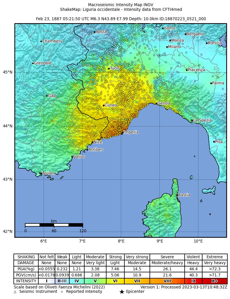
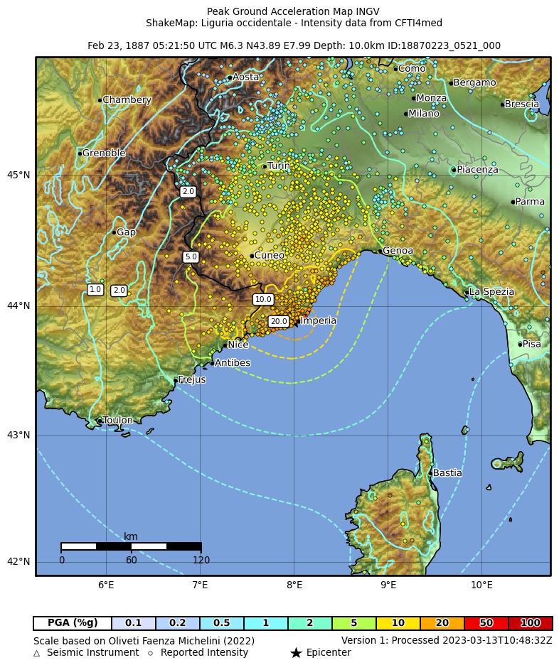
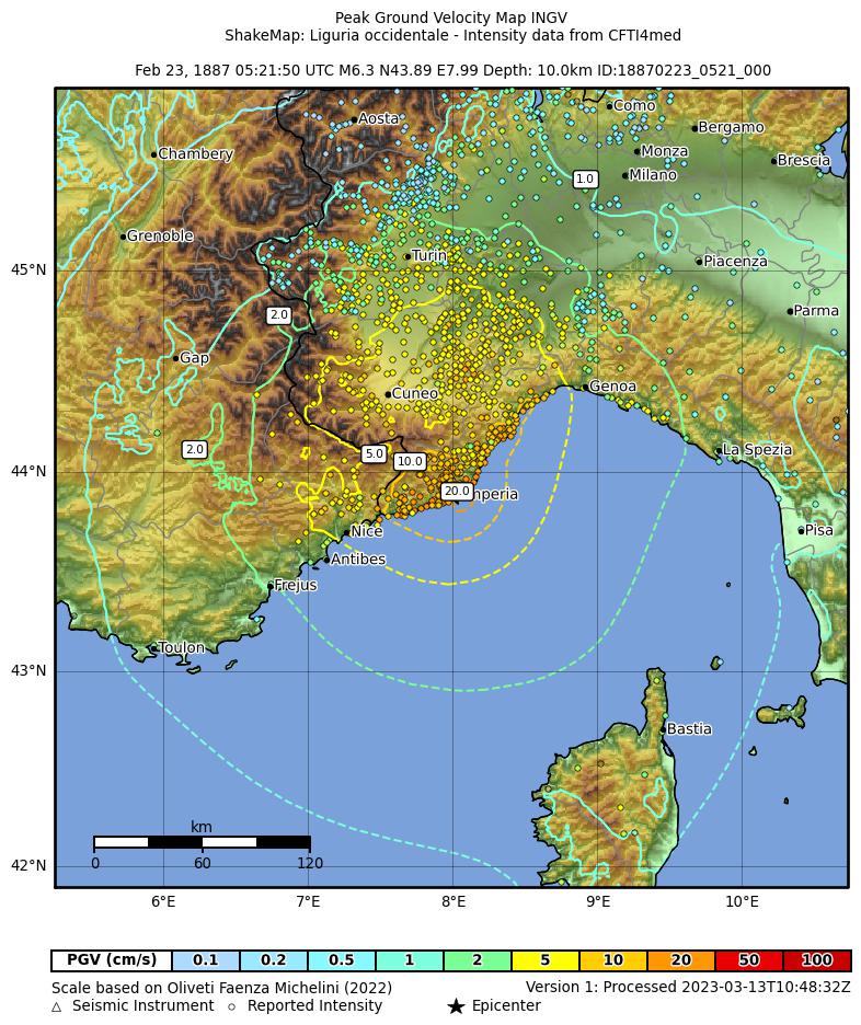
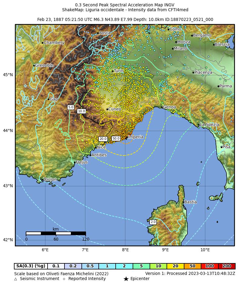
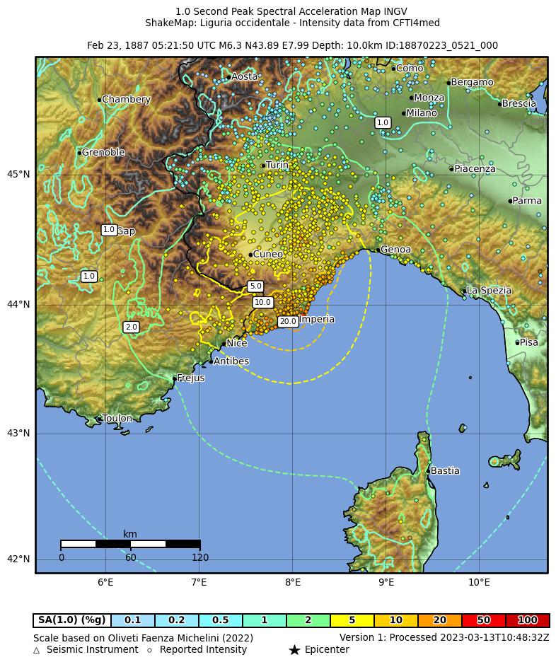
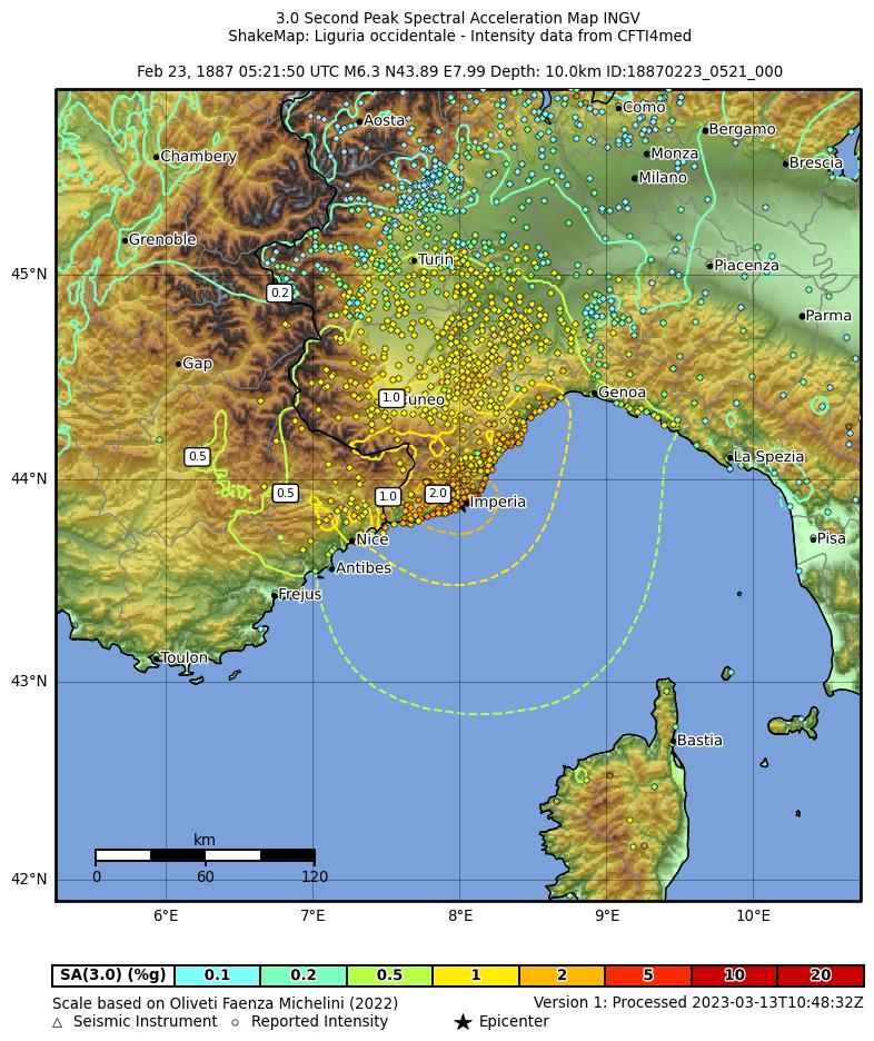
Shakemaps calcolate a partire dai dati macrosismici di DBMI15 (MDP da CFTI4med)
secondo le procedure descritte in Michelini et al. 2020..
Queste mappe e relativi dati sono anche disponibili sul sito INGV Shakemap.
Shakemaps calculated from DBMI15 macroseismic data (MDP from CFTI4med)
using procedures described in Michelini et al. 2020.
These maps and related data are available at the INGV Shakemap website also.
 |
Maramai, A., Graziani, L., Brizuela, B. (2019). Euro-Mediterranean Tsunami Catalogue (EMTC), version 2.0. Istituto Nazionale di Geofisica e Vulcanologia (INGV). https://doi.org/10.13127/TSUNAMI/EMTC.2.0 ► AbstractA unified catalogue containing 293 tsunamis generated in the European and Mediterranean seas since 6150 B.C. to current days is presented. It is the result of a systematic and detailed review of all the regional catalogues available in literature covering the study area, each of them having their own format and level of accuracy. The realization of a single catalogue covering a so wide area and involving several countries was a complex task that posed a series of challenges, being the standardization and the quality of the data the most demanding. A “reliability” value was used to rate equally the quality of the data for each event and this parameter was assigned based on the trustworthiness of the information related to the generating cause, the tsunami description accuracy and also on the availability of coeval bibliographical sources. Following these criteria we included in the catalogue events whose reliability ranges from 0 (“very improbable tsunami”) to 4 (“definite tsunami”). About 900 documentary sources, including historical documents, books, scientific reports, newspapers and previous catalogues, support the tsunami data and descriptions gathered in this catalogue. As a result, in the present paper a list of the 290 tsunamis with their main parameters is reported. The online version of the catalogue, available at http://roma2.rm.ingv.it/en/facilities/data_bases/52/catalogue_of_the_euro-mediterranean_tsunamis, provides additional information such as detailed descriptions, pictures, etc. and the complete list of bibliographical sources. Most of the included events have a high reliability value (3= “probable” and 4= “definite”) which makes the Euro-Mediterranean Tsunami Catalogue an essential tool for the implementation of tsunami hazard and risk assessment.
▼ Descrizione dell'eventoEvent description Epicenter coordinates, origin time, earthquake intensity (MCS scale) and equivalent moment magnitude from Rovida et al. (2016). Maximum run-up from Eva et al. (1995) and from Eva and Rabinovich (1997). This is one of the most relevant earthquakes occurred in Liguria. During this seismic period many shocks occurred, but only three were particularly strong. The main shock caused severe damage in an area between Mentone and Albissola, about 100 km along the coast. More than 650 victims and about 160 injured people. Shock violently felt by ships in the sea between Corsica and the coast of Liguria (Issel, 1888). In most of the villages along the coast (Riviera Ligure) the sea withdrew and returned to its normal level (Mercalli, 1897a). Detailed information on sea lowering in the localities listed below given by Taramelli and Mercalli (1888) and Issel (1888). At Diano Marina, sea level lowering about 30 cm. At Porto Maurizio the sea level lowered 30 cm (Charlon, 1887). According to Issel (1888), a sea lowering of about 1 m was observed; then the sea rose about 1 m above msl, flooding the beach. During the third shock the harbor remained almost dried and then the sea came back violently. At Sanremo some vessels broke moorings. The sea level lowered about 1m. A lot of fish was found on the beach (Gatta, 1889). Fluxes and refluxes were observed with 40 cm amplitude (Mercalli, 1897a). At Oneglia 4 m sea withdrawal was noted. At Ospedaletti the sea withdrew about 1 m. At Alassio about 30 m sea withdrawal (less than 1 m in height) at the first shock was observed, followed by beach flooding. The same fact occurred during the second and third shocks. At Loano and Finale Marina 2 m sea withdrawal observed. At Savona the sea withdrew and a lot of fish was found on the beach. At Laigueglia the sea withdrew for more than 15 m (Minasi, 1971). At Santa Margherita Ligure 15 m sea withdrawal was noted. At Genoa after the main shock the sea withdrew in some places 10 m, in others 30 m (Tacchini, 1887). At Albissola the sea withdrew about 1 m after the two shocks. Also at Nice and Antibes the sea level lowered and the sea bottom was dried (Tacchini, 1887). At Cannes and Antibes the sea lowered for about 1 m leaving boats on dried land and then the water rose for 2 m (BRGM, 2013). At Villefranche the sea significantly withdrew (BRGM, 2013). At Menton just after the shock the sea withdrew 2-3 meters for about 4-5 min, leaving the sea bottom dried. The sea came back to the shore and the sea level rose for about 2 m (BRGM,2013) Maximum run-up (1.5 m) measured at Imperia (Eva et al., 1995; Eva and Rabinovich, 1997). Tide-gauge records available for Genoa and Nice (Mercalli, 1897a). The analysis of the available tide-gauge records give some information on tsunami: the first wave reached Genoa harbor in about 24 min after the shock and Nice in about 28 min. For both localities the first wave was negative, supporting the assumption that the earthquake was produced by release of a stress along an offshore normal fault. (Eva et al., 1995; Eva and Rabinovich, 1997). Event studied and simulated by Eva et al.(1995), Eva and Rabinovich (1997). Permanent coastal changes (shoreline regression) observed at Loano and between Imperia and Ospedaletti (Taramelli and Mercalli, 1888; Naudin, 1887; Ascari et al., 1937) are reported in Boschi et al. (1995). Abbo G., Biga F., Corazza A., Ivani A. and Romero A., (1987). Il terremoto del 23 febbraio 1887 nel Dianese, Miscellanea di Storia Arte Archeologia Dianese, repertorio fotografico a cura di A.Calcagno e G. Gallone (dati scientifici, statistici e cronaca del drammatico avvenimento), monography, pp. 467, 97 ill., Diano Marina (in Italian). Antonopoulos J., (1990). Data for investigating tsunami activity in the Mediterranean Sea. Science of Tsunami Hazards, 8, 39-52. Ascari, M., Baccino, L. and Sanguineti, G., (1937). Ricerche sulle variazioni delle spiagge Italiane: Le spiagge della Riviera Ligure, Consiglio Nazionale delle Ricerche, Roma, tav. 8, pp.237 (in Italian). Baratta M., (1901). I terremoti d' Italia F.lli Bocca, 950 pp., Torino (in Italian). Baratta M., (1936). I terremoti in Italia. R.Accademia Naz. dei Lincei, Pubblicazione della Commissione Italiana per lo studio delle grandi calamità, pp.181, Vol. 6, Firenze (in Italian). Boschi E., Ferrari G., Gasperini P., Guidoboni E., Smriglio G. and Valensise G. (eds.), (1995). Catalogo dei forti terremoti in Italia dal 461 a.C. al 1980, ING-SGA, 970 pp., Bologna (in Italian). Caputo M. and Faita G., (1984). Primo catalogo dei maremoti delle coste italiane. Atti dell’ Accademia Nazionale dei Lincei, Memorie Classe Scienze Fisiche Matematiche e Naturali, Serie VIII, Vol. XVII, 213-356, Roma (in Italian). Charlon E., (1887). Note sur le tremblement de terre du 23 février 1887. Boll. Vulc. Ital., 14, 18-23 (in French). Eva C. and Rabinovich A.B., (1997). The February 23, 1887 tsunami recorded on the Ligurian coast, western Mediterranean. Geophys. Res. Lett., 24, 17, 2211-2214 2211. https://doi.org/10.1029/97GL02110 Eva C., Augliera P., Cattaneo M., Corradi N., Eva E., Fanucci F., Solarino S., Spallarossa D., Palau C., (1995). GITEC Final Scientific Report, Chapter 2, 2.1-2.16. Gatta L., (1889). A proposito del terremoto ligure del 1887. Bollettino della Società Geografica Italiana, Serie III, Vol. II (in Italian). Issel A., (1888). Il terremoto del 1887 in Liguria. Appunti di Arturo Issel, Supplemento al Bollettino del Regio Comitato Geologico d' Italia, anno 1887 (in Italian). Mercalli G., (1897a). I terremoti della Liguria e del Piemonte, 147 pp., 3 Tav, Napoli (in Italian). Naudin M. C., (1887). Quelques observations et réflections au suject du tremblement de terre du 23 février, à Antibes. Comptes Rendus de l'Académie des Sciences, vol. 104, pp. 822-823 Paris 8in French). Rovida A., Locati M., Camassi R., Lolli B., Gasperini P. (eds), (2016). Catalogo Parametrico dei Terremoti Italiani (CPTI15). Istituto Nazionale di Geofisica e Vulcanologia (INGV). https://doi.org/10.6092/INGV.IT-CPTI15 Soloviev S.L., Solovieva O.N., Go C.N., Kim K.S and Shchetnikov N.A., (2000). Tsunamis in the Mediterranean Sea 2000 B.C. - 2000 A.D.. Kluwer Academic Publishers. Soloviev S. L., (1990). Tsunamigenic zones in the Mediterranean Sea. Natural Hazards, 3, 183-202. Tacchini P., (1887). Il terremoto del 23 febbraio 1887. Bollettino della Società Geografica Italiana, Serie II, Vol. XII, 301-305 (in Italian). Taramelli T. and Mercalli G., (1888). Il terremoto ligure del 23 febbraio 1887. Annali dell' Ufficio Centrale di Meteorologia e di Geodinamica, Serie II, Vol. VIII, Parte IV, 296 pp (in Italian). Tinti S. and Maramai A., (1996). Catalogue of tsunamis generated in Italy and in Côte d'Azur, France: a step towards a unified catalogue of tsunamis in Europe. Annali di Geofisica, vol. 39, n.6, 1253-1299. Tinti S., Maramai A. And Graziani L., (2004). The new catalogue of Italian tsunamis. Natural Hazards, 33, 3, pp. 439-465. BRGM, (2013): Tsunamis observed in France. Bureau de Recherches Géologiques et Minières, www.tsunamis.fr Guidoboni E., Ferrari G., Mariotti D., Comastri A., Tarabusi G., Sgattoni G., Valensise G. (2018). CFTI5Med, Catalogo dei Forti Terremoti in Italia (461 a.C.-1997) e nell’area Mediterranea (760 a.C.-1500). Istituto Nazionale di Geofisica e Vulcanologia (INGV). https://doi.org/10.6092/INGV.IT-CFTI5 Minasi G., (1971). Notizie storiche della città di Scilla, Edizioni Parallelo 38, Reggio Calabria, (In Italian). |
Non sono stati trovati link ad altri database online.No links to other online databases for this earthquake were found.


|


