ASMI Archivio Storico Macrosismico ItalianoItalian Archive of Historical Earthquake Data


 |
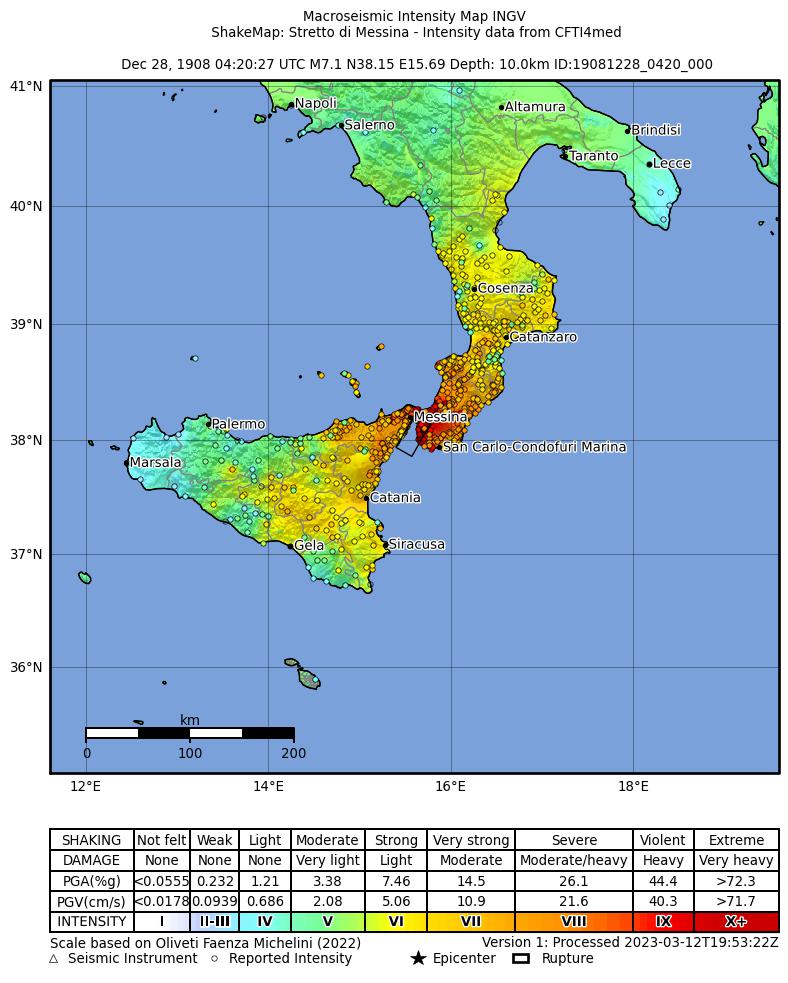
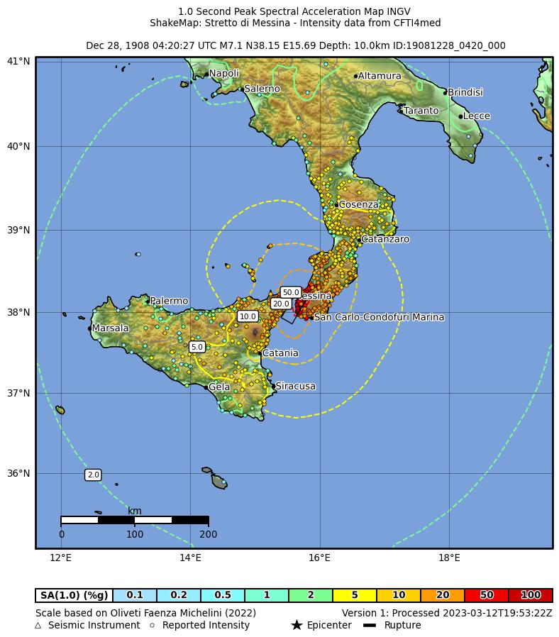
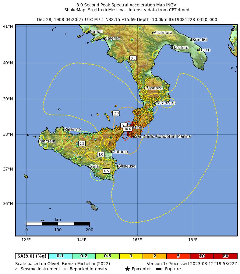
▼ Descrizione dell'eventoEvent description Epicenter coordinates, origin time, intensity (MCS scale) and equivalent moment magnitude from Rovida et al., (2016). Max run-up value from Tinti and Giuliani (1983b). Data to compute tsunami magnitude in Tinti et al. (1999a). This is one of the strongest earthquakes ever occurred in Italy. Messina and Reggio Calabria were completely destroyed, and also many other villages. Partial destructions involved most of Calabria and Sicily. In Messina all buildings ruined and just after the shock a violent fire broke out. In Reggio Calabria all buildings ruined. The area of destruction was about 6,000 square km wide. More than 60,000 people died. Some strong foreshocks occurred on December 5, 6, 23, 25 and many aftershocks occurred till February 1909. A violent tsunami occurred in the Messina Straits causing severe damage and hundreds of victims. In most places the first movement was a sea withdrawal (in some places about 200 m) for a few minutes. Then the sea flooded the coast with at least three big waves. The sea level oscillations lasted many hours, gradually diminishing (Platania, 1909a; Eredia, 1910). The tsunami reached its maximum intensity in the Calabrian coast near Pellaro, Lazzaro and Gallico and, in the Sicily coast, in Giardini and S.Alessio (Baratta, 1909). It was very strong in the eastern Sicily coast and it was observed in the Tyrrhenian Calabria as far as Porto S.Venere and in Sicily as far as Trabia and Termini Imerese (Baratta, 1909; Platania, 1909a). In some localities the biggest wave was the first, while in others it was the second. The observed maximum wave height generally was an inverse function of the distance from the epicenter, but in the Strait this was masked by local amplification effects (Platania, 1909a; Riccò, 1909). A post-event survey allowed estimating damage, flooding and run-up: it was ascertained that the tsunami caused many victims (the exact number is unknown, due to the catastrophic effects of the earthquake) and severe damage to buildings, ships, boats and nature. The tsunami involved mainly the eastern Sicily coast but also the southern and the northern ones. In Messina the shock was followed by some tsunami waves: according to the Harbour Office, the first wave was observed after 8-10 min, while according to some others accounts the first arrival was after 15 min. At least three huge waves were observed, the first was the biggest. The first sea movement was an ingression with waves coming from SE that violently invested the harbour causing severe damage to infrastructures, boats and houses. Many boats were carried onshore and destroyed, some shipwreck occurred; many vessels moored in the harbour felt a sudden considerable sea level rise just a few minutes after the shock, and some of them broke their mooring. All piers in the harbour lowered and some of them collapsed. The English cemetery was completely destroyed and the wave was 3 m high. The same water height was observed close to the Harbour Office. Most damage was observed in the southern beach of the city, close to the Portalegna stream. Between Portalegna and Zaera streams the tsunami waves reached about 6 m height causing the destruction of some buildings (Platania, 1909b; Oddone, 1909; Martinelli, 1909; Franchi, 1909; Eredia, 1910). At Torre Faro a few minutes after the shock the sea withdrew and the inundated the beach with more than one wave that overcame the usual water edge. The max wave height was 75-80 cm (Baratta, 1910; Platania, 1909a). At Itala Marina the max measured runup was 7.90m at the mouth of the Itala stream (Platania, 1909a,b; Baratta, 1910). At Paradiso, North of Messina, the first movement was negative and then the sea violently invaded the beach. The measured run-up was 3.70 m in the Casicelle district, in the northern part of the village. Houses close to the beach were severely damaged by the waves and many boats were carried to the beach (Platania, 1909b; Baratta, 1910). At Pace the first sea movement was negative with a maximum withdrawal of 2 m. Two big waves were observed. Many small houses ruined and the water level reached 4.70 m. The tsunami caused 3 victims (Platania, 1909b; Baratta, 1910). At Brolo a light tsunami effect was observed (Baratta, 1910; Martinelli, 1909). At Porticatello two men and a child were swept by the waves (Baratta, 1910; Platania, 1909a). In the village of Grotta the sea withdrew then the waves invaded the shore reaching the houses of the village. Max runup 2.80m (Platania, 1909b; Baratta, 1910). At Galati Marina the tsunami occurred 5-7 min after the shock with three waves, the second being the biggest. Many buildings were destroyed or severely damaged, mainly in the southern edge of the village. A lot of big trees uprooted. Many ships carried onshore beyond the coastal road and damaged. 14 people killed. Maximum measured runup 8 m (Platania, 1909a, b; Baratta, 1910). At Santa Teresa di Riva 6 min after the shock the tsunami was observed: the sea water penetrated for about 150m inland (Baratta, 1901; Platania, 1909a; Martinelli, 1909). In the Bucalo district (between Furci Siculo and Santa Teresa a Riva) about 5 min after the shock a tsunami occurred: many walls and gardens were destroyed by the waves. (Baratta, 1901; Platania, 1909a; Martinelli, 1909). Max measured runup 6.10 m. (Baratta, 1910; Platania, 1909b). At Briga Marina the first sea movement was negative. Many houses destroyed and 46 people drowned. In the San Paolo district damage was heavier than in other places in Sicily. The second wave was the biggest; the water reached the first floor of the houses close to the seashore. Many houses were severely damaged or destroyed and a lot of trees were uprooted. Maximum water inundation was 150m and maximum runup 8.5m. The total number of victims for the tsunami was 45 (Platania, 1909a, b; Baratta, 1910; Cavasino, 1935). Measured runup 8.5 m and 6.3 m measured at Contrada Malati. According to Platania (1909b) the number of victims in Contrada Malati was 26. At Giampileri Marina the wave was 7.20 m high. The sea water reached the coastal road and many walls collapsed; many trees uprooted (Platania, 1909a, b; Baratta, 1910; Cavasino, 1935). At Capo Molini about 5-6 min after the shock the sea withdrew and then three big waves invaded the beach, the second one being the biggest. In the inner seaport the max runup was 4.90m while in the outer one the runup was 3.50m. Two warehouses close to the seashore and some fishing boats were damaged (Baratta, 1910; Platania, 1909b). At Santa Tecla about 10 min after the shock the tsunami was observed. In the southern part of the village the coast is low and citrus groves, gardens and walls were destroyed by the waves. Max runup was 5.70 m and max water inundation about 150 m (Platania, 1909a, b; Baratta, 1910). At Torre Archirafi the max runup was 5.70m. The sea water inundated the beach for about 200m and destroyed many houses close to the beach, causing 10 victims. Just outside the village, in the north, the water caused severe damage to vineyards and citrus groves (Platania, 1909a, b; Baratta, 1910). At Nizza di Sicilia the sea withdrew: according to some eyewitnesses the withdrawal occurred 5 min after the shock while some other sources report the phenomenon 15 min after the shock. Then the sea flooded the beach with three waves. In the vicinity of the Fiumedinisi stream the wave reached 5.70 m height while further south, in the Nave district, max height was 9.20m and the max inundation was 120 m. Many walls and boats destroyed, a lot of trees uprooted (Platania, 1909a, b; Baratta, 1910). At Scaletta Zanclea the sea withdrawal was about 150 m; then the water invaded the beach crossing the water edge for about 300m. The tsunami demolished a long segment of the railway and caused severe damage to buildings that were protected by the railways bed. Boats that were in the sea were highly lifted and then they fell. Max runup 8 m (Platania, 1909a,b; Baratta, 1910) . At Fondachello the runup was 5.60m. The village was not damaged by the waves since there were no buildings or walls close to the seashore (Baratta, 1910; Platania, 1909b). At Roccalumera 6 min after the shock the water invaded the beach with 5 waves reaching the coastal road more than 200m inland. The max runup (8m) was measured in the northern edge of the village, in the Farina district, while close to the Saracen Tower the runup was 7m. The tsunami demolished many walls, flooded several houses and caused damage to many boats. A little girl died (Platania, 1909a, b; Baratta, 1910). At Spadafora the sea was very agitated (Baratta, 1910; Martinelli, 1909). At Furci about 10 min after the shock three waves were observed, the third being the biggest. The sea flooded the beach for about 150m and the runup was 8m. The tsunami caused some light change in the coastline and light erosion (Baratta, 1910; Platania, 1909a). At La Gurna the runup was 5.60m; no damage was observed since there were no buildings or walls close to the seashore (Platania, 1909a; Baratta, 1910). At Letojanni about 4 min after the shock a sea the initial withdrawal of about 100 m was noted, followed by a violent inundation of 120 m with no damage. Max runup 5m (Baratta, 1910; Platania, 1909a; Martinelli, 1909). At Oliveri a considerable tsunami effect was observed (Baratta, 1910; Martinelli, 1909). At Alì Marina the wave height was 8.40m at the mouth of the Mastroguglielmo stream. Many boats damaged. Trees uprooted. Slight damage was observed (Platania, 1909a, b; Baratta, 1910). At Stazzo the max runup was 4.30m. No damage was observed (Platania, 1909a; Baratta, 1910). At Giardini Naxos about 5 min after the shock a first sea withdrawal of 200 m. was observed and then the sea invaded the beach up to the coastal road and the nearby houses. Three big waves noted and the level of the water reached 9.50 m at the railway station. Two people killed and many boats damaged. In the south of the Casazza district some old houses destroyed and many ground floors flooded; many trees uprooted; a concrete hovel were carried for about 60 m; max runup 5.30m. At Capo Schisò max runup 8.40m (Platania, 1909a, b; Baratta, 1910). At Isola Bella in the inlet between Capo Sant'Andrea and Capo Taormina the waves reached about 3.50m above the sea level; in the isthmus that connects the small island with the coast the runup was about 4m; a wall was destroyed and some trees were damaged (Platania, 1909a). At Sant'Alessio less than 15 min after the shock the tsunami was observed: three big waves invaded the beach, the first one being the smallest. In the Siena district, in the northern part of the village, the max runup was 7.10m and the water penetrated inland up to the main road destroying walls and trees. Some walls and trees were also destroyed in the southern part of the village. Near the rail tunnel the max runup of the whole Sicily coast was measured: 11.70m (Platania, 1909a, b; Baratta, 1910; Eredia, 1910). At Spisone a house was destroyed and the runup was 5m (Platania, 1909a). At Guidomandri Inferiore the max measured runup was 6.40m and the inundation was stopped by the presence of the railway bed (Platania, 1909a; Baratta, 1910). At Riposto immediately after the shock the sea withdrew 12m from the usual water edge and 10 min later the first wave invaded the beach for 150 m along the Jungo riverbed. Some walls collapsed and some small buildings close to the lighthouse were damaged. Boats and others objects from the beach were carried in the streets. 13 people died. The max measured runup was 6m. About 12 min after the first wave, a second smaller wave came not causing any damage (Platania, 1909a,b; Martinelli, 1909; Baratta, 1910; Cavasino, 1935). At Acireale the first sea movement was negative, three big waves. Max runup 3.7 m (Baratta, 1910; Platania, 1909a). At Aci Trezza, about 8-10 min after the shock the sea withdrew up to the "Palummeddu" rock (Platania, 1909b) and then three big waves invaded the beach, reaching the houses. (Baratta, 1910).The wave period was about 6 min (Platania, 1909b). Max. measured runup 7.1 m at the "Stabilimento Amenta" (not identified place). In the southern part of the village, at la Guarnazza, some walls were destroyed. One victim. Measured runup values: Casa Sorrentino: 4.6 m., Piazza Marina 5 m, Stabilimento Amenta: 7.1 m., Casa Monteleone: 5.9 m., seaport Acitrezza: 5 m (Baratta, 1910). Twentysix fishing boats were lost or damaged, many fish were found on the beach. Some boats were carried in the Marina street. The sea water inundated the ground floor of the Castorina Palace causing severe damage (Platania, 1909b). A little boy was killed by the waves (Platania, 1909a,b; Martinelli, 1909; Baratta, 1910). At Aci Castello about 5 min after the shock the sea withdrew and then some waves flooded the beach; many boats were carried in the open sea. The max runup was 3.50m (Platania, 1909a,b; Martinelli, 1909; Baratta, 1910). At Ognina about 10 min after the shock the sea withdrew for about 200m; then the water invaded the harbour and the beach carrying some boats in the open sea and crashing them against the rocks. The water flooded the Mancini Battaglia square flooding houses and shops and destroying a lateral wall of the stream close to the square. Max runup 5m (Baratta, 1910; Platania, 1909a). At Pozzillo many boats were carried inland and damaged. The max runup was 4.80m (Platania, 1909a; Baratta, 1910; Guidoboni et al., 2018). At Catania about 10 min after the shock lowered leaving the sea bottom visible. Then some big waves were observed and the maximum inundation was 100-200 m. The water inundated the quay and flooded the rooms in the Harbour Office; in the district of Civita the sea water flooded some houses, surrounded Villa Pacini and reached to skim the Duomo Square. Many boats damaged; damage to buildings was insignificant but 3 children were killed by the waves. In the wall of the tide-gauge station it was possible to distinguish 4 different wave marks. (Platania, 1909b; Baratta, 1910; Eredia, 1910; Guidoboni e Mariotti, 2001). Some fishing boat were carried up to Dusmet street (Platania, 1909b). Villa Pacini, a park close to the harbour, was completely inundated and many fish and seaweeds were found (Platania, 1909b; Baratta, 1910). The period of the first waves was estimated between 10-12 min (Platania, 1909b). At La Plaia beach, south of Catania, about 10-15 min after the shock the waves went beyond the small dune barrier delimiting the low sand beach, destroying it. The wall of the sharpshooting field was demolished in many parts; the forecourt was flooded and the water penetrated in the thicket at the back of the beach carrying some boats up to 700m from the water edge (Platania, 1909b; Baratta, 1910; Eredia, 1910). At Santa Maria La Scala (small harbour) 8 min after the shock the sea withdrew leaving the sea bottom dry and then it came back inundating the beach (Platania, 1909b; Baratta, 1910). The sea penetrated the groundfloor of some houses, leaving fish and shells on the ground. Some boats were carried inland (Platania, 1909b). Maximum runup 3.70 m. (Platania, 1909b; Baratta, 1910). The highest waves were three, with a period of about 10 min. (Platania, 1909b). At Brucoli about 8 min after the shock a withdrawal of more than 200m was observed. Then some waves invaded the natural harbour. Boats that were moored in the vicinity of the beach were carried in the open sea during the first withdrawal and then they were carried inland for more than 50m beyond the water edge; many fish and shell were left on the ground. Boats that were in the Canal (at the mouth of Panagia stream), suffered severe damage. No victims were reported (Platania, 1909b). The runup was 4.30m in the vicinity of the castle, 3.75m in the canal-harbour and 1.75m at the Spasale (Baratta, 1910; Platania, 1909a). At Augusta the first sea movement was positive and about 20 min after the shock the water invaded the beach with many waves, the first one being the biggest. The water flooded more than 700 m inland carrying many boats and causing severe damage to the Regina saltpan. Max runup 1.8 m was measured at the saltpan (Platania, 1909b; Martinelli, 1909; Baratta, 1910). Measured runup: Salina Regina 1.85 m (Platania, 1909b; Baratta, 1910), countryside bridge 2 m (Platania, 1909b), Salina del Mulinello 0.60 m (Platania, 1909b). At Avola shortly after the shock the sea withdrew and then invaded the beach with two waves not very violent. The water penetrated inland for about 15m beyond the water edge and the max runup was l.30m (Baratta, 1910). At Siracusa about 10 min after the shock the sea level lowered and then rose. During a second withdrawal many boats remained high and dry in the harbour canal. Then the sea water inundated the quay. Many boats were damaged. The max runup was 2 m (Baratta, 1910; Platania, 1909a; Martinelli, 1909). At Santa Panagia the sea crossed the water edge for about 100m in the inlet; the runup was about 1 m. The factories of the tuna-fishing nets were not damaged (Platania, 1909a). At Marzamemi a few min after the shock the sea withdrew and then invaded the beack with weack waves. Max runup about 1m (Baratta, 1910). At Calabernardo a first movement negative was observed about 30 min after the shock. Then three waves violently hit the beach with a max runup of 10 m (Baratta, 1910). At Portopalo di Capo Passero the sea first withdrew and then invaded the beach at the Cozzo Spadaro lighthouse, carrying some fishing boats; runup about 1.50m (Baratta, 1910; Martinelli,1909). At Licata about 10-15 min after the shock a violent wave invaded for many metres the beach east of the harbour. Some other minor waves were observed. The tsunami did not cause damage to the boats and the max runup was 1.25m (Baratta, 1910; Platania, 1909b). At Mazzarelli soon after the shock the sea, already agitated, withdrew for about 10m and then inundated the beach crossing the usual limit for 6 m. The max runup was about 2m (Baratta, 1910). At Terranova di Sicilia the sea was very agitated before the shock but some people referred that they seemed to see a sea withdrawal and a flooding greater that a normal wave (Baratta, 1910; Platania, 1909a). At Pozzallo the sea initially withdrew and then invaded the beach penetrating for about 20m beyond the water edge; max runup was 1.60m (Baratta, 1910; Platania, 1909a). At Scoglitti after the shock the sea, already agitated, invaded the beach roaring (Baratta, 1910; Martinelli, 1909). At Porto Empedocle no waves were observed but some boats had difficulties in docking in the harbour, due to a sea rising of 50cm (Platania, 1909b; Baratta, 1910). In the northern Sicily coast, in the harbour of Milazzo the sea flooded the quays reaching a max height of 75 cm. Moored ships swerved with any damage and some boats were stranded for a few moments (Platania, 1909a; Baratta, 1910; Martinelli, 1909). At Marina di Patti the sea first withdrew and then invaded the beach with some light waves. No damage were observed (Baratta, 1910). At Tonnarella soon after the shock the sea withdrew and then invaded the beach with some waves penetrating inland for more than 50m beyond the water edge (Baratta, 1910). At Cefalù the sea was already very agitated before the shock; after the shock the water invaded the beach with strong waves, crossing the usual water edge for about 6 m (Baratta, 1910; Platania, 1909a). At Termini Imerese the sea withdrew for more than 3m, then strongly invaded the beach and withdrew again. For some hours after the shock the sea rose every 5 min of about 70-80 cm with waves length of about 2 m (Baratta, 1910; Martinelli, 1909). At Trabi the sea withdrew for about 4-5m and then came back with a wave that crossed the usual water edge for about 10m (Baratta, 1910). The Calabrian coasts facing the Messina straits were severely affected by the tsunami. In particular, at Reggio Calabria the tsunami occurred about 6-10 min after the shock causing disastrous effects: many houses rose to the ground, harbour infrastructures severely damaged, many boats and vessels in the harbour damaged. The first sea movement was negative with a withdrawal of about 200 m and then three huge waves invested the shore reaching a max height of 7 m and penetrating for more than 50m inland. The railways were completely destroyed and all the coaches that were on the rails were thrown against each other. South of the harbour the tsunami impact was less violent and the runup was 3.50m. The sea water flooded Via Marina and also part of the crosscutting streets; buildings close to the beach were raised to the ground. Max measured runup 9.7 m (Platania, 1909a, b; Martinelli, 1909; Baratta, 1910). In the southernmost part of the city the railway bridge Sant'Agata (at 5.80 m above the sea level) was damaged (Baratta, 1910; Platania, 1909a; Martinelli, 1909). At Gallico about 10-12 min after the shock a very large inundation (about 400 m) occurred, reaching the church located near the railway station; three big waves were observed at 4 min of each other and the max measured runup was 5.40 m; along the seaside some houses damaged by the shock were destroyed by the tsunami, mainly in the southernmost edge of the village (Silipi district). Many vineyards destroyed; some boats were damaged and carried 40 m inland. Along the Bozzurro riverbed (today Quarnaro Street) big boulders were moved for more than 100 m. The victims due to the tsunami were 112 (Baratta, 1910; Platania, 1909a; Mercalli, 1909). At Villa San Giovanni the first sea movement (about 10-12 min after the shock) was negative. Three/four waves were observed, inundating the shore for 120 m and hitting the buildings that were under the railways ballast. Some boats were carried inland for about 80 m. Max runup 5 m. In the spinning mill Erba two people perished due to the waves (Baratta, 1910; Platania, 1909a; Guidoboni et al., 2018). At Scilla about 5 min after the shock a first sea movement negative with a withdrawal of 30 m was observed. Then the wave slowly invaded the beach overstepping the usual water edge and rising for about 1 m. At Marina Grande beach the sea water reached the houses without damage (Baratta, 1910; Platania, 1909a). At Pellaro, a few minutes after the shock sea first withdrew for about 20 m and then three waves, the second being the biggest, invested the coast. At the southern end of the village, near the Lume stream, the measured run-up was 13 m. The tsunami caused severe damage and close to the beach a lot of buildings was destroyed and the ruins were carried away. A boat was carried up to Madonnella Square and it was left inside the church. A railway bridge, located 150 m from the shoreline and about 7 m above the sea level, was wiped out by the violent waves and the sea water penetrated for other 200 . In the stretch of coast from San Giovanni to Lume streams the water edge advanced about 3035 m respect to the previous line. At Punta di Pellaro the max inundation was 500 m. Many people perished for the wave's impact (Platania, 1909a, b; Martinelli, 1909; Baratta, 1910). At Lazzaro the first sea movement was positive, with an inundation of about 250 m. Three waves were observed, max measured runup 10.50 m. The part of the village in front of the sea was almost completely destroyed by the waves: houses, church and plantations were destroyed. In the southern end of the village, near the Saetta stream, part of the Vittorio Emanuele Street was removed by the waves and a long stretch of beach permanently disappeared. Relevant beach erosion was observed. According some source the victim was 27 while some other referred about 90 people killed. (Platania, 1909a,b; Martinelli, 1909; Baratta, 1910; Cavasino, 1935). At Capo d'Armi first sea movement positive: the water invaded the beach with some huge waves, the first one being the strongest. The max runup was about 4 m (Baratta, 1910). At Gioiosa Marina the first sea movement was positive and two waves reached the houses 50m far from the beach. Then the sea withdrew 4m beyond the usual water edge (Baratta, 1910). At Melito di Porto Salvo a few min after the shock the sea invaded the beach with three big waves for about 200 m inland. The max runup was 3 m. No relevant damage observed (Baratta, 1910; Platania, 1909a) At Archi the waves demolished some walls and damaged trees and plantations; some boats in Palmara place were carried inland for about 40 m; a long stretch of beach was submerged for more than 12 m (Baratta, 1910; Platania, 1909a). At Palizzi Marina about 20 min after the shock the sea withdrew more than 100m from the water edge and about 2 min later violently came back towards the beach with 3-4 waves, the first one being the biggest. The sea water reached the built-up area flooding a house and removing furnishings and furniture. The max runup was about 3m (Baratta, 1910). At Cannitello about 10 min after the shock a very strong wave (about 1 m high) invaded the beach for more than 30 m. Boats that were in the sea were carried inland and then brought again in the open sea. No damage was observed (Baratta, 1910). At Catona the max wave height was 4 m. The sea water penetrated in land for about 150 m, destroying some buildings. Some victims (Baratta, 1910; Guidoboni et al., 2018). At Palmi a strong sea agitation was observed; a tsunami wave was noted in the vicinity (Baratta, 1910; Platania, 1909a). At Siderno a wave crossed for a short time the water edge (Baratta, 1910). At Bocale the sea water went beyond the railway and inundated the coastal road flooding the ground floor of some houses and destroying gardens (Baratta, 1910). At Fornace 4 min after the shock the sea withdrew and then invaded the beach with two waves, being the second the biggest that caused destruction. The sea crossed the railway (located at 10.60 m above sea level) carrying heavy scraps for more than 20 m inland. Almost all buildings located between the beach and the railway were destroyed. According to eyewitness the victims due to the tsunami were 89 (Platania, 1910). At Pezzo Inferiore the sea withdrew and then invaded the beach for about 150 m wiping out the sand dunes 2.50m high (Baratta, 1910). At Occhio gardens and citrus groves were destroyed by the waves that wiped out the ruins of the buildings destroyed by the earthquake. The sea water inundated the shoreline crossing the railway ballast. A stretch of beach about 70 m wide was permanently inundated (Mercalli, 1909; Platania, 1909a). At Pentimele the sea waves reached the railway ballast and some vineyards were flooded. About 80 fishing boats and many coaches were left on the beach. The coastline retreated for about 50 m (Baratta, 1910; Guidoboni et al., 2018). At Porto Santa Venere (now Vibo Valentia) the sea level was seen to rise of about 1.50m and then gradually diminishing (Baratta, 1910). At San Gregorio the tsunami reached about 6 m height and most of the damage were observed close to the mouth of Armo stream while in the southern part of the village the tsunami effects were irrelevant. Many trees uprooted or damaged; a boat was carried beyond the railway embankment (Baratta, 1910; Platania, 1909a; Mercalli, 1909).At San Leo the runup was more than 7 m; the waves devastated gardens and citrus grove (Baratta, 1910). At Roccella Ionica immediately after the shock the sea withdrew; then invaded the beach with three violent waves, penetrating for about 25m inland. According to an eyewitness the max runup was 7 m (Baratta, 1910; Martinelli, 1909). At Saline Ioniche the sea overstepped the railway and inundated the shore for 25-30m flooding the salt works and the nearby vine yards (Baratta, 1910). At Brancaleone Marina the sea withdrew and then slowly came back to the usual water edge; this phenomenon was repeated for 2-3 times (Baratta, 1910). At Cirò Marina almost at the same time of the shock the sea withdrew and then invaded the beach with violent waves. The water penetrated inland for about 20m and the max runup was 6 m (Baratta, 1910). At Crotone about 30 min after the shock in both the old and the new habour two movements of high and low tide were observed: the sea water rose and lowered for about 2m (Baratta, 1910; Martinelli, 1909). At Bova Marina about 10-15 min after the shock in the sea a strong agitation was noted and 5 min later the sea withdrew for a few meters; then the water invaded the beach with violent sea waves overcoming the usual water edge for more than 200m and causing severe damage to buildings and plantations (Baratta, 1910). At Bianco a long time after the shock the sea invaded the beach with many strong waves. The sea water reached 2m above the sea level (runup) and the inundation was about 30 m (Baratta, 1910; Platania, 1909a). At Capo Spartivento a slight tsunami was observed (Baratta, 1910). At Nicotera Marina the sea noteworthy withdrew from the water edge and after few min a wave flooded the beach reaching the houses (Mercalli, 1909; Baratta, 1910). At Tropea just after the shock the sea level rose for about 2.50m and then slowly diminished for some hours (Baratta, 1910). At Scalea three hours after the shock the sea rose and the water penetrated for about 20m inland (Baratta, 1910). In the Aeolian Islands the tsunami was only weakly felt. In Stromboli about 1 min after the shock the tsunami was observed: the first sea movement was positive with a max inundation of less than 10 m. No damage reported (Platania, 1909b; Baratta, 1910). In the Maltese islands the tsunami was observed in many places, both with inundations and withdrawals. In Malta Island at Sliema about one hour and a half after the shock a sudden sea rise was observed in the harbour; at 06:45 GMT the max sea rise of 92 cm was measured and the water crossed the road flooding the shops (Platania, 1909a; Baratta, 1910). At Misida, in Malta Island, at 06:10 GMT in the harbour a first sea rising was observed and until 07:40 four rising were noted, each one preceded and followed by a lowering; the max height was 1.40m. The sea water inundated the square flooding shops along the dock and reaching the third step of the churchyard. Many boats were stranded (PLatania, 1909a,b; Baratta, 1910). At La Valletta in the Grand Harbour (south of the city) a sea rising of a few centimeters was measured in front of Punta Ricasoli; at 05:30 GMT a sea rising of 40 cm was measured and at 05:45 GMT one rising of 68cm (tide gauge record available). In the northern harbour, Marsamxett Harbour, at Sa Maison the first sea rising was measured at 05:45GMT; later, close to the jetty four moored vessels were submerged during the sea reflux and a long stretch of the sea bottom remained visible (Baratta, 1910; Platania, 1909b). At Birzebugga, in the Malta Island, about 1 hour after the shock the sea level lowered for about 1.20m and then it rose for about 1.50m above the mean sea level flooding the ground floor of houses and shops located close to the sea; some fishing boats were left on the beach (Platania, 1909b; Baratta, 1910). At Marsaxlokk, in the Malta Island, the sea flooded the beach reaching the church, the houses and the huts close to the beach; some boats were damaged (Platania, 1909b; Baratta, 1910) (Baratta, 1910). In the Gozo island at Xlendi the first sea movement was negative and an inundation of about 6 m was observed ( Baratta, 1910). At Miggiarro, in the Gozo Island, about 1 hour after the shock the sea level rose about 60cm ant then it lowered and rose four times reaching a max height of 90cm at 07:10GMT. When the sea withdrew again, a big moored vessel touched the sea bottom and it was left dry for some time (Baratta, 1910; Platania, 1909a, b). At Marsalforno, in the Gozo Island, a sea level rising of 72cm and a lowering of 38cm was measured (Baratta, 1910; Platania, 1909b). Many submarine cables were broken. Five tide-gauge records are reproduced by Platania (1909b): Palermo, Civitavecchia, Malta and Naples. |